
Mount Despair (Washington) facts for kids
Quick facts for kids Mount Despair |
|
|---|---|
 |
|
| Highest point | |
| Elevation | 7,296 ft (2,224 m) NAVD 88 |
| Prominence | 1,852 ft (564 m) |
| Geography | |

Mount Despair
Location in Washington (state)

Mount Despair
Location in the United States
|
|
| Parent range | Cascade Range, North Cascades |
| Topo map | USGS Damnation Peak |
| Climbing | |
| First ascent | Fred Beckey (1939) |
Mount Despair is a tall and rugged mountain. You can find it in the northern part of North Cascades National Park. This park is located in Washington state, in the United States. Just northeast of Mount Despair is another mountain range called the Picket Range.
The mountain got its interesting name from a person named Lage Wernstedt. He worked for the U.S. Forest Service. In the 1920s, he was busy mapping out this whole area. The name "Mount Despair" first appeared on official Forest Service maps in 1931.
Contents
Mountain Weather: Mount Despair's Climate
Mount Despair is in a special weather area called the "marine west coast climate zone." This means it's near the ocean, which affects its weather. Most of the weather systems that bring rain and snow start over the Pacific Ocean. They then travel northeast towards the Cascade Mountains.

When these weather systems reach the North Cascades, the tall mountains force the air upwards. As the air rises, it cools down and drops its moisture. This moisture falls as rain or snow onto the Cascades. This process is called orographic lift. Because of this, the western side of the North Cascades gets a lot of rain and snow. This is especially true during the winter months.
In winter, the weather is often cloudy. But in summer, high-pressure systems over the Pacific Ocean usually bring clear skies. The snow here tends to be wet and heavy because of the ocean's influence. This can make the risk of avalanches higher.
How Mount Despair Was Formed: Its Geology
The North Cascades area, where Mount Despair is located, has some very dramatic landscapes. You'll see jagged peaks, sharp ridges, and deep valleys carved by glaciers. These amazing features and the big changes in elevation were created by geological events that happened millions of years ago.
The story of the Cascade Mountains began a very long time ago, in the late Eocene Epoch. This was when the North American Plate started to move over the Pacific Plate. This movement caused a lot of volcanic activity. Also, small pieces of the Earth's crust, called terranes, came together. This helped form the North Cascades about 50 million years ago.
About two million years ago, during the Pleistocene period, huge sheets of ice called glaciers moved across the land. They advanced and then melted back many times. As they moved, they scraped and shaped the landscape. They left behind piles of rock debris. The U-shaped valleys you see in the area today were carved out by these glaciers. The combination of the land being pushed up (called uplift) and cracks forming in the Earth's crust (called faulting), along with the glaciers, created the tall peaks and deep valleys of the North Cascades.
Nearby Mountains
Mount Despair is surrounded by other interesting peaks. Some of these include:
Images for kids
-
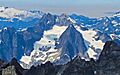
Mount Despair seen from the east, showing its glacier.

