Mount Terror (Washington) facts for kids
Quick facts for kids Mount Terror |
|
|---|---|

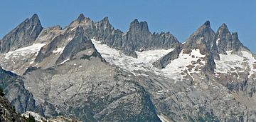
Mount Terror is the pyramid to far left
|
|
| Highest point | |
| Elevation | 8,151 ft (2,484 m) NGVD 29 |
| Prominence | 1,911 ft (582 m) |
| Geography | |
| Location | Whatcom County, Washington, U.S. |
| Parent range | Picket Range, North Cascades |
| Topo map | USGS Mount Challenger |
| Climbing | |
| First ascent | 1932 by William Degenhardt and Herbert Strandberg |
| Easiest route | rock climb or scramble |

Mount Terror is a tall mountain found in the Cascade Range. It is located in the northwestern part of Washington State, specifically in Whatcom County. This impressive peak is part of the North Cascades National Park. It sits about 15.7 miles (25.3 km) south of the border between Canada and the United States.
Contents
Exploring Mount Terror and Nearby Peaks
Mount Terror is the highest point in the southern part of the Picket Range. The Picket Range, which has both a north and south section, is known for being the most rugged and "Alpine" area in the Cascade Range. This means it has sharp, jagged peaks and deep valleys, much like the Alps in Europe.
Who First Climbed Mount Terror?
The first time anyone successfully climbed Mount Terror was in 1932. Two climbers from Seattle, William Degenhardt and Herbert Strandberg, made the first ascent. They were members of a climbing group called The Mountaineers.
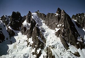
About 30 years later, a climber named Ed Cooper led a team. They were the first to climb the more difficult north face of Mount Terror. This was a much bigger challenge!
Mountains Close to Mount Terror
Mount Terror is surrounded by many other interesting mountains. Some of these nearby peaks include:
Understanding Mount Terror's Weather
Mount Terror is located in a special climate zone called the marine west coast climate. This type of climate is found in western North America. It means the weather is often influenced by the nearby Pacific Ocean.
How Weather Forms in the Cascades
Most weather systems start over the Pacific Ocean. They then travel northeast towards the Cascade Mountains. As these weather systems get closer to the North Cascades, the tall peaks of the mountains force the air upwards. This process is called Orographic lift. When the air rises, it cools down, and the moisture in it turns into rain or snowfall. This is why the western side of the North Cascades gets a lot of precipitation, especially snow in the winter.
Temperatures and Snowfall
Because of the mild ocean influence, areas west of the Cascade mountain crest rarely get extremely cold (below 0°F or -18°C) or extremely hot (above 80°F or 27°C). During winter, it's usually cloudy. However, in summer, high-pressure systems over the Pacific Ocean often bring clear skies. The snow in this region tends to be wet and heavy. This can sometimes lead to a high risk of avalanches, which are large slides of snow down a mountain.
The Amazing Geology of Mount Terror
The North Cascades area has some of the most rugged and dramatic landscapes in the Cascade Range. You can see jagged peaks, sharp ridges, and deep valleys carved by glaciers. The unique geology and huge changes in elevation have created the different climates we see today.
How the Cascade Mountains Formed
The story of the Cascade Mountains began millions of years ago, during a time called the late Eocene Epoch. At that time, the North American Plate was slowly moving over the Pacific Plate. This movement caused many volcanic eruptions and created igneous rocks.
Also, small pieces of the Earth's outer layers, called oceanic and continental lithosphere, formed special land blocks called terranes. These terranes came together to create the North Cascades about 50 million years ago.
The Role of Glaciers and Earth Movements
During the Pleistocene period, which started over two million years ago, glaciers repeatedly moved across the landscape. As they advanced and retreated, they scraped away the land and left behind piles of rock debris. The "U"-shaped valleys you see in the rivers today are a direct result of these ancient glaciers.
The combination of land being pushed upwards (called uplift) and cracks forming in the Earth's crust (called faulting), along with the action of glaciers, has shaped the tall peaks and deep valleys of the North Cascades.
 | Charles R. Drew |
 | Benjamin Banneker |
 | Jane C. Wright |
 | Roger Arliner Young |

