Mount Forde (Fairweather Range) facts for kids
Quick facts for kids Mount Forde |
|
|---|---|

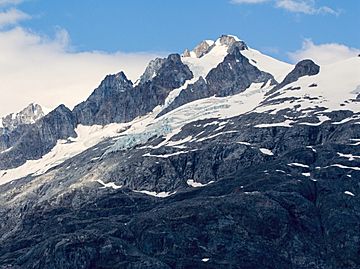
Mount Forde, east aspect from Tarr Inlet
|
|
| Highest point | |
| Elevation | 6,883 ft (2,098 m) |
| Prominence | 1,010 ft (310 m) |
| Parent peak | Mount Turner (8661+ ft) |
| Geography | |
| Location | Hoonah-Angoon Alaska, United States Cassiar Land District British Columbia, Canada |
| Parent range | Fairweather Range Saint Elias Mountains |
| Topo map | USGS Skagway A-6 NTS 114P/3 |
| Climbing | |
| Easiest route | Scrambling East ridge |
Mount Forde is a mountain peak that stands 6,883 feet (2,098 meters) tall. It is also known as Boundary Peak 161 because it sits right on the border between Canada and the United States. This mountain is found in the Fairweather Range, which is part of the larger Saint Elias Mountains. It's located in southeast Alaska and British Columbia.
Mount Forde is on the edge of Glacier Bay National Park and Preserve. It's close to the top of Tarr Inlet. The mountain is about 109 miles (175 km) northwest of Juneau. It is also about 4.4 miles (7.1 km) northeast of Mount Turner, which is a taller peak nearby. Even though Mount Forde isn't super high, it rises very steeply from the water. This means it looks much taller than it actually is.
The mountain was named on December 4, 1928, by the Geographical Names Board of Canada. It honors John Preston Forde. He was a surveyor and engineer who worked for the Canadian government. John Forde visited Tarr Inlet in 1925 and 1928 to measure how much glaciers were shrinking. He was also a leader in the Alpine Club of Canada from 1910 to 1914. He climbed many mountains in the Canadian Rockies, Selkirk Mountains, and Coast Ranges. The United States officially approved the mountain's name on January 9, 1929. You can see Mount Forde from Tarr Inlet, which is a popular spot for cruise ships. The best time to see the mountain is usually from May through June, when the weather is clearest.
Climate
Mount Forde has a subarctic climate. This means it has very cold and snowy winters. The summers are mild, but not hot. Temperatures can drop below −20 °C (–4 °F). With the wind, it can feel even colder, sometimes below −30 °C (–22 °F). This cold climate helps small glaciers form on the mountain's sides. Larger glaciers like the Margerie Glacier to the south and Ferris Glacier to the north are also nearby. Water from melting snow and ice on Mount Forde flows into Glacier Bay Basin.
 | Audre Lorde |
 | John Berry Meachum |
 | Ferdinand Lee Barnett |


