
Mount Hardy (Washington) facts for kids
Quick facts for kids Mount Hardy |
|
|---|---|

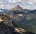
Mount Hardy from upper Snowy Lake
|
|
| Highest point | |
| Elevation | 8,080 ft (2,460 m) |
| Prominence | 1,480 ft (450 m) |
| Geography | |

Mount Hardy
Location in Washington (state)

Mount Hardy
Location in the United States
|
|
| Parent range | North Cascades |
| Topo map | USGS Mount Arriva |
| Type of rock | Granite |
| Climbing | |
| First ascent | Sidney Schmerling, Hermann Ulrichs in 1933 |
| Easiest route | Climb, class 3 |
Mount Hardy is a tall mountain in Washington state. It stands 8,080+ ft (2,460+ m) high. You can find it in Okanogan County.
This mountain is part of the Okanagan Range, which is a smaller part of the larger North Cascades mountain range. Mount Hardy is located west of Methow Pass. It is also near where the Methow River begins. The land around it is managed by the Okanogan National Forest.
The closest taller mountain is Golden Horn. It is about 1.75 miles (2.82 km) to the northeast. You can often see Mount Hardy from the North Cascades Highway. This road runs along the mountain's lower southwest side.
Mountain Weather: Climate of Mount Hardy
Mount Hardy is in a special weather zone called the marine west coast climate. This means it gets a lot of moisture from the Pacific Ocean. Most weather systems start over the Pacific. They then move northeast towards the Cascade Mountains.
When these weather systems reach the North Cascades, the tall peaks force the air upwards. As the air rises, it cools down. This causes the moisture in the air to turn into rain or snowfall. This process is called Orographic lift. Because of this, the western side of the North Cascades gets a lot of rain and snow. This is especially true during winter.
In winter, the weather is often cloudy. But in summer, high-pressure systems over the Pacific Ocean bring clear skies. This means there is often little or no cloud cover. Because of the ocean's influence, the snow tends to be wet and heavy. This can lead to a high risk of avalanches.
How Mountains Form: Geology of Mount Hardy
The North Cascades mountains have very rugged land. They feature sharp peaks, long ridges, and deep valleys carved by glaciers. Many years ago, huge geological events shaped this area. These events created the varied landscape and big changes in elevation. These changes also led to different climates and types of plants in the area.

The Cascade Mountains started forming millions of years ago. This was during a time called the late Eocene Epoch. The North American Plate slowly moved over the Pacific Plate. This movement caused many volcanic eruptions. Also, small pieces of the Earth's crust, called terranes, joined together. This helped create the North Cascades about 50 million years ago. Mount Hardy, like many peaks in the Washington Pass area, is made of Rapakivi texture granite. This rock comes from a large body of igneous rock called the Golden Horn batholith.
About two million years ago, during the Pleistocene period, glaciers covered the land. These huge ice sheets moved forward and backward many times. As they moved, they scraped away the land. They left behind piles of rock and debris. The river valleys in this area have a "U"-shape. This shape was created by these recent glaciers. The rising of the land (called uplift) and cracks in the Earth's crust (called faulting) worked with the glaciers. Together, they formed the tall peaks and deep valleys you see in the North Cascades today.
Images for kids
-
Mt. Hardy from ESE

