
Mount Lorette (Alberta) facts for kids
Quick facts for kids Mount Lorette |
|
|---|---|
.jpg)
Mount Lorette in November
|
|
| Highest point | |
| Elevation | 2,487 m (8,159 ft) |
| Prominence | 49 m (161 ft) |
| Parent peak | Skogan Peak (2662 m) |
| Listing | Mountains of Alberta |
| Geography | |

Mount Lorette
Location in Alberta

Mount Lorette
Location in Canada
|
|
| Location | Alberta, Canada |
| Parent range | Kananaskis Range Canadian Rockies |
| Topo map | NTS 82J/14 |
| Geology | |
| Age of rock | Cambrian |
| Type of rock | limestone |
| Climbing | |
| First ascent | 1952 |
| Easiest route | Scramble |
Mount Lorette is a tall mountain located in Kananaskis Country in the Canadian Rockies of Alberta, Canada. It stands about 2,487 meters (8,159 feet) high. Mount Lorette's closest higher peak is Skogan Peak, which is about 2.0 kilometers (1.2 miles) to the north-northwest. You can easily spot Mount Lorette from Highway 40, especially if you're driving north of the Kananaskis Village area. It's a well-known landmark in the Canadian Rockies.
Contents
The Story Behind Mount Lorette's Name
Mount Lorette got its name in 1922. It was named after a place called Lorette Spur. This was a ridge located north of Vimy Ridge in France. Lorette Spur was a very important location during World War I. Capturing it was a big moment in French military history.
First Climbers and Official Naming
The first time anyone successfully climbed to the top of Mount Lorette was in 1952. A group of climbers, including R.C. Hind, B. Richardson, L. Keeling, J. Manry, J. Dodds, and C. McAllister, made this first ascent.
The mountain's name was officially recognized in 1953. This was done by the Geographical Names Board of Canada.
How Mount Lorette Was Formed
Mount Lorette is made of sedimentary rock. This type of rock forms from layers of sand, mud, and tiny bits of plants and animals that settle over millions of years. These layers were laid down during ancient times, from the Precambrian to the Jurassic periods.
Mountain Building
Over time, these flat layers of rock were pushed and folded. This happened during a major mountain-building event called the Laramide orogeny. During this event, the rocks were pushed east and even slid over younger rock layers. This process slowly created the tall peaks we see today, like Mount Lorette.
Weather and Water Around Mount Lorette
Mount Lorette is located in a subarctic climate zone. This means it has very cold and snowy winters. The summers are usually mild, not too hot. Temperatures can drop below −20 °C (–4 °F). With the wind chill, it can feel even colder, sometimes below −30 °C (–22 °F).
Water Flow
When snow melts or rain falls on the mountain, the water flows down its sides. This is called precipitation runoff. This water eventually drains into the Kananaskis River. The Kananaskis River then flows into the Bow River, which is a larger river in Alberta.
Gallery
-
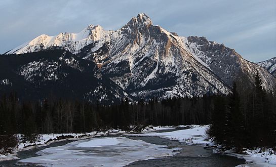
Mount Lorette seen from Kananaskis valley with Skogan Peak behind to left
-
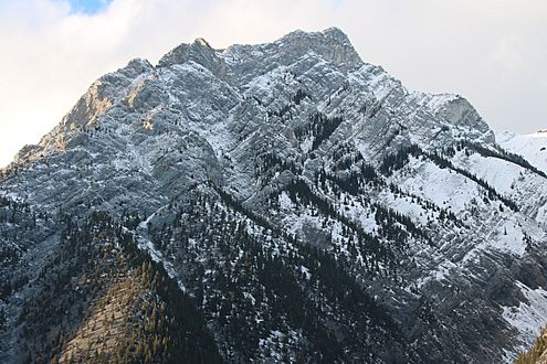
Close-up
-
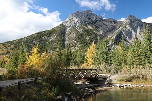
From Lorette Ponds
-
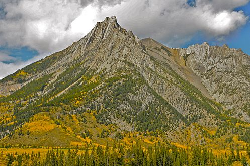
Mount Lorette in autumn

.jpg)
.jpg)

