
Mount Roosevelt facts for kids
Quick facts for kids Mount Roosevelt |
|
|---|---|

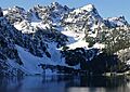
Mount Roosevelt and Snow Lake
|
|
| Highest point | |
| Elevation | 5,835 ft (1,779 m) |
| Prominence | 275 ft (84 m) |
| Isolation | 0.5 mi (0.80 km) |
| Parent peak | Kaleetan Peak (6,259 ft) |
| Geography | |

Mount Roosevelt
Location in Washington (state)

Mount Roosevelt
Location in the United States
|
|
| Location | King County Washington state, U.S. |
| Parent range | Cascade Range |
| Topo map | USGS Snoqualmie Pass |
| Climbing | |
| Easiest route | Scrambling Southeast Route |
Mount Roosevelt is a mountain in Washington state. It stands 5,835 feet (1,778 meters) tall. You can find it about 6 miles (10 km) northwest of Snoqualmie Pass.
This mountain is part of the Cascade Range. It is located within the Alpine Lakes Wilderness. This area is managed by the Mount Baker-Snoqualmie National Forest. Mount Roosevelt overlooks the western shore of Snow Lake. It is also about 2 miles (3 km) north of Kaleetan Peak, which is its closest taller neighbor. Rain and melting snow from the mountain flow into streams that feed the Snoqualmie River. The name Mount Roosevelt was officially recognized in 1989 by the U.S. Board on Geographic Names.
Mountain Weather and Climate
Mount Roosevelt is in a "marine west coast" climate zone. This type of climate is found in western North America. Most weather systems come from the Pacific Ocean. They travel northeast towards the Cascade Range.
When these weather systems reach the Cascade Mountains, they are forced to rise. This causes them to drop their moisture as rain or snow onto the mountains. This process is called "orographic lift." Because of this, the west side of the Cascades gets a lot of rain and snow, especially in winter.
During winter, the weather is often cloudy. However, in summer, high-pressure systems over the Pacific Ocean bring clear skies. The ocean's influence means that the snow tends to be wet and heavy. This can lead to a high risk of avalanches.
How the Mountains Were Formed
The Alpine Lakes Wilderness has very rugged land. It features sharp peaks, long ridges, deep valleys carved by glaciers, and tall granite walls. There are also more than 700 mountain lakes in this area.
Long ago, huge geological events created this varied landscape. These events caused big changes in elevation across the Cascade Range. These elevation changes led to different climates in various areas. These climate differences then created different types of plant life, defining the "ecoregions" here. The land in this area ranges from about 1,000 feet (300 meters) high in lower spots to over 9,000 feet (2,700 meters) on Mount Stuart.
The Cascade Mountains began forming millions of years ago. This was during the late Eocene Epoch. At that time, the North American Plate was slowly moving over the Pacific Plate. This movement caused many volcanic eruptions. Also, small pieces of the Earth's crust, called "terranes," helped create the North Cascades about 50 million years ago.
During the Pleistocene period, which started over two million years ago, glaciers repeatedly moved across the land. As they moved, they scraped and shaped the landscape, leaving behind rock debris. The last glaciers in the Alpine Lakes area started to melt and retreat about 14,000 years ago. By 10,000 years ago, they had moved north of the Canada–US border. The "U"-shaped valleys you see today were formed by these glaciers. The rising of the land (uplift) and cracks in the Earth's crust (faulting), along with glaciation, have created the tall peaks and deep valleys of the Alpine Lakes Wilderness.
Images for kids
-
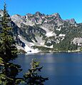
Mount Roosevelt and Snow Lake
-
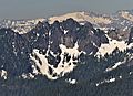
Southwest view from Mt. Defiance. (Mt. Hinman in the distance)
-
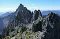
Mt. Roosevelt summit with Kaleetan Peak behind
-
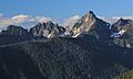
Mt. Roosevelt (left) and Kaleetan Peak (right) from Bandera Mountain
-
Mount Roosevelt in autumn


