Mt. Angel, Oregon facts for kids
Quick facts for kids
Mt. Angel, Oregon
|
|
|---|---|
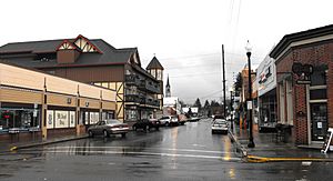
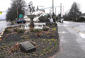
Charles Street in central Mt. Angel
|
|
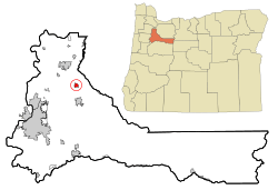
Location in Oregon
|
|
| County | Marion County |
| Incorporated | 1893 |
| Area | |
| • Total | 1.14 sq mi (2.94 km2) |
| • Land | 1.14 sq mi (2.94 km2) |
| • Water | 0.00 sq mi (0.00 km2) |
| Elevation | 177 ft (54 m) |
| Population
(2020)
|
|
| • Total | 3,392 |
| • Density | 2,985.92/sq mi (1,153.24/km2) |
| Time zone | UTC-8 (Pacific) |
| • Summer (DST) | UTC-7 (Pacific) |
| ZIP code |
97362
|
| Area codes | 503, 971 |
| FIPS code | 41-50150 |
| GNIS feature ID | 2411176 |
| Website | www.ci.mt-angel.or.us |
Mt. Angel or Mount Angel is a city in Marion County, Oregon, United States. It is about 18 miles (29 km) northeast of Salem, Oregon, on Oregon Route 214. In 2020, the city had a population of 3,392 people. Mt. Angel is part of the larger Salem Metropolitan Statistical Area.
Contents
History of Mt. Angel
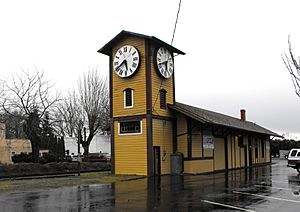
Mt. Angel was first settled in 1850 by Benjamin Cleaver. He planned a town and called it Roy. Later, in 1881, a train station was built and named Fillmore. The next year, a post office called Roy opened. But these names did not last.
In 1881, a group of Benedictine monks came to Oregon from Engelberg, Switzerland. They were led by Father Adelhelm Odermatt. They wanted to start a new monastery in America. Father Odermatt found a good spot at Lone Butte. Soon after, many people from Bavaria settled in the area. Because of Father Odermatt's work, the city, post office, and Lone Butte became known as Mount Angel in 1883. This name is an English translation of Engelberg. He also started Mount Angel Abbey, a Benedictine monastery and school. It moved permanently to Mt. Angel in 1884.
The city of Mt. Angel officially became a city on April 3, 1893. A post office for the Abbey was set up nearby, called Saint Benedict, Oregon.
Mount Angel Abbey's Story
Mount Angel Abbey is still located on Mount Angel. The local Kalapuya people called the butte Tapalamaho, which means "Mount of Communion." In 1889, the Abbey opened Mount Angel Seminary to train priests. The first wooden buildings were destroyed by fire in the 1890s. Another big fire in 1926 burned down the second monastery building.
The current monastery building was finished in 1928. More buildings were added later, including a library designed by famous Finnish architect Alvar Aalto in 1970. In 2007, a bell tower was added to the abbey church. It has eight bells, including the largest swinging bell in the Pacific Northwest.
The Benedictine Sisters of Mt. Angel, also known as the Queen of Angels Monastery, were founded in 1882. They have helped the Willamette Valley community ever since. They teach in schools and churches, work as counselors, and are artists, cooks, and gardeners. The Sisters also run two special programs: the Shalom Prayer Center and the St. Joseph Shelter.
Geography and Climate
Mt. Angel covers about 1.14 square miles (2.94 square kilometers) of land. There is no water area within the city limits.
The city is located in the Pudding River area. It sits on the Mount Angel Fault. This fault caused the 1993 Scotts Mills earthquake, which damaged many buildings in the town, especially the local church.
Local Weather
Mt. Angel has a warm-summer Mediterranean climate. This means it has warm, dry summers. The average monthly temperatures do not go above 71.6°F (22°C).
Population Information
| Historical population | |||
|---|---|---|---|
| Census | Pop. | %± | |
| 1900 | 537 | — | |
| 1910 | 545 | 1.5% | |
| 1920 | 986 | 80.9% | |
| 1930 | 979 | −0.7% | |
| 1940 | 1,032 | 5.4% | |
| 1950 | 1,315 | 27.4% | |
| 1960 | 1,428 | 8.6% | |
| 1970 | 1,973 | 38.2% | |
| 1980 | 2,876 | 45.8% | |
| 1990 | 2,778 | −3.4% | |
| 2000 | 3,121 | 12.3% | |
| 2010 | 3,748 | 20.1% | |
| 2020 | 3,392 | −9.5% | |
| U.S. Decennial Census | |||
2010 Census Details
In 2010, there were 3,748 people living in Mt. Angel. There were 1,505 households and 724 families. The city had about 2,882 people per square mile (1,113 per square kilometer).
Most residents (82.6%) were White. About 12.1% were from other races, and 3.3% were from two or more races. About 26.1% of the population identified as Hispanic or Latino.
In terms of age, 27% of residents were under 18 years old. The average age in the city was 37.1 years.
Economy
The biggest employers in Mt. Angel in 2000 included:
- Wilco (a farm supply company)
- Providence Benedictine Nursing Center
- Mt. Angel Towers
- Highland Laboratories
- The Mt. Angel School District
Arts and Culture
Yearly Events
Mt. Angel is famous for its yearly Oktoberfest. This festival is the biggest of its kind in the Pacific Northwest. It started in 1966 with 39,000 visitors. By the late 1980s, it grew to 375,000 visitors! Oktoberfest has:
- Beer and wine gardens
- Sports games and races
- Arts and crafts shows
- A farmers market
- Community dinners with sausage and sauerkraut
- Lots of food, games, and fun entertainment
Places to Visit
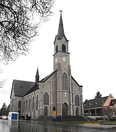
Mt. Angel is home to the historic Queen of Angels Monastery. It is still run by the Benedictine Sisters. The 1912 Saint Mary Catholic Church is also here. Both are listed on the National Register of Historic Places. Windischar's General Blacksmith Shop is another historic building in the city.
In 2006, the city built a 49-foot (15 m) tall glockenspiel. This musical clock tower is the largest in the United States. It is part of the Edelweiss Village Building and was ready for Oktoberfest 2006.
Education
Mt. Angel has three schools, all part of the Mt. Angel School District. One of these is John F. Kennedy High School.
Colegio César Chávez
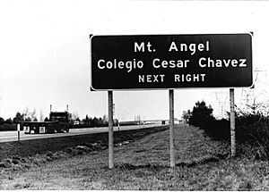
Colegio César Chávez was a special college program in Mt. Angel from 1973 to 1983. At that time, it was the only four-year college in the country specifically for Latino students. The college was supported by the famous Chicano activist Cesar Chavez, who visited it twice. In 1978, this college helped more Mexican American students graduate than Oregon State University and University of Oregon combined! Cipriano Ferrel, who later started a farmworker's union in Oregon, graduated from Colegio Cesar Chavez.
In the mid-1980s, the land and buildings of the former college were bought and given to the Benedictine sisters. The Benedictine sisters now use the old college buildings as the St. Joseph Shelter, which helps people in need.
Local Media
Mt. Angel is served by several local newspapers:
- The weekly Appeal Tribune from Silverton
- The monthly publications Our Town and Our Town Life
- The weekly Woodburn Independent
City Services
Getting Around
Roads
Mt. Angel is located on Oregon Route 214. The closest major highway, Interstate 5, is about 10 miles (16 km) to the west.
Trains
The Willamette Valley Railway provides train service to Mt. Angel.
Air Travel
The closest airport is Aurora State Airport, located in Aurora.
Utilities
The City of Mt. Angel provides water and wastewater treatment services. Natural gas is supplied by NW Natural, and electricity comes from Portland General Electric.
Healthcare
The closest hospital is Silverton Hospital, which is about 4 miles (6 km) away in Silverton.
See also
 In Spanish: Mount Angel para niños


