Munbilla, Queensland facts for kids
Quick facts for kids MunbillaQueensland |
|||||||||||||||
|---|---|---|---|---|---|---|---|---|---|---|---|---|---|---|---|

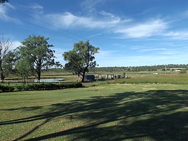
Farm on Kengoon Road, 2015
|
|||||||||||||||
| Population | 93 (2021 census) | ||||||||||||||
| • Density | 8.16/km2 (21.1/sq mi) | ||||||||||||||
| Postcode(s) | 4309 | ||||||||||||||
| Area | 11.4 km2 (4.4 sq mi) | ||||||||||||||
| Time zone | AEST (UTC+10:00) | ||||||||||||||
| Location |
|
||||||||||||||
| LGA(s) | Scenic Rim Region | ||||||||||||||
| State electorate(s) | Scenic Rim | ||||||||||||||
| Federal Division(s) | Wright | ||||||||||||||
|
|||||||||||||||
Munbilla is a small rural town and area in the beautiful Scenic Rim Region of Queensland, Australia. It's a quiet place with a population of about 93 people, according to the 2021 census. It's known for its peaceful countryside and a bit of interesting railway history!
Contents
Exploring Munbilla's Landscape
Munbilla is surrounded by nature. A creek called Warrill Creek flows along its north-western edge. This creek helps shape the local landscape.
In the northern part of Munbilla, you'll find a special spot called Mooroo Ougee Lagoon. It's a waterhole that always has water, no matter the season. It's a great place for local wildlife.
A Glimpse into Munbilla's Past
Munbilla got its name from an old railway station. In 1886, the Queensland Railways Department chose the name. They used words from the Yuggera Aboriginal language. Mun means much and billa means water. So, Munbilla means a large lagoon.
The Old Railway Lines
Munbilla was once an important stop on a railway line. The Fassifern railway line was Queensland's very first branch railway line. It opened from Ipswich to Harrisville in 1882.
Later, in 1887, the line was extended to Dugundan. Munbilla had its own railway station on Macfarlane Road. This line helped people and goods travel around. However, it closed down in June 1964.
Another railway line, the Mount Edwards branch line, also started near Munbilla railway station. This line opened in stages, reaching Kalbar in 1916 and Mount Edwards in 1922. The Mount Edwards line closed in 1960.
Who Lives in Munbilla?
The number of people living in Munbilla has changed a little over the years.
- In 2011, the area around Munbilla had about 434 people.
- By 2016, the population of Munbilla itself was 100 people.
- In the most recent census in 2021, 93 people lived in Munbilla.
Learning in Munbilla
There are no schools directly in Munbilla. However, students can attend nearby schools.
Primary Schools
The closest government primary schools are:
- Harrisville State School in Harrisville (to the north)
- Roadvale State School in Roadvale (to the south-east)
- Kalbar State School in Kalbar (to the south)
- Warrill View State School in Warrill View (to the north-west)
Secondary Schools
For high school, the nearest government secondary school is Boonah State High School. It is located in Boonah to the south of Munbilla.


