Roadvale, Queensland facts for kids
Quick facts for kids RoadvaleQueensland |
|||||||||||||||
|---|---|---|---|---|---|---|---|---|---|---|---|---|---|---|---|

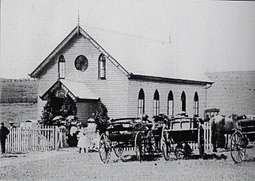
Milbong (St Luke's) Lutheran Church, circa 1907
|
|||||||||||||||
| Population | 303 (2021 census) | ||||||||||||||
| • Density | 17.31/km2 (44.8/sq mi) | ||||||||||||||
| Postcode(s) | 4310 | ||||||||||||||
| Area | 17.5 km2 (6.8 sq mi) | ||||||||||||||
| Time zone | AEST (UTC+10:00) | ||||||||||||||
| Location |
|
||||||||||||||
| LGA(s) | Scenic Rim Region | ||||||||||||||
| State electorate(s) | Scenic Rim | ||||||||||||||
| Federal Division(s) | Blair | ||||||||||||||
|
|||||||||||||||
Roadvale is a small country area in Queensland, Australia. It's part of the Scenic Rim Region. In 2021, about 303 people lived there.
Contents
Where is Roadvale?
Roadvale is about 14 kilometers (9 miles) north of the town Boonah. It's also about 79 kilometers (49 miles) southwest of Brisbane, Queensland's capital city.
Its main street is called Gray Street. This street is also known as the Roadvale-Kalbar Road.
Roadvale is becoming important for growing small crops. These crops are sold in South East Queensland and other places. A main road, Ipswich – Boonah Road (State Route 93), goes right through Roadvale from north to south.
Roadvale's Past
Roadvale got its name from an old railway station. The Queensland Railways Department named it in 1887. They chose the name because the station was located where different roads met.
The Old Railway Line
The Fassifern railway line was Queensland's very first branch railway line. It opened from Ipswich to Harrisville in 1882. Later, in 1887, the line was extended to Dugundan.
The Roadvale area had its own stop called Roadvale railway station. This station was on the corner of Wilsons Plains Road and Redhill Road. The railway line closed down in June 1964.
Early Churches in Roadvale
The Milbong Lutheran Church, also known as St Luke's Lutheran Church, first opened in 1885. A new church building was built on the same spot and opened in 1906. The old church was moved and used as a barn, but it later burned down.
The church closed in 1974, and the building was taken away. However, the cemetery is still there. The church site and cemetery are on the Ipswich Boonah Road.
St Andrew's Anglican Church was officially opened in 1912. In 1926, this church also closed. Its building was moved all the way to Camp Hill in Brisbane. There, it became the Anglican Church of the Annunciation.
A Big Fire
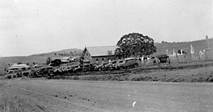
In 1915, a large fire destroyed most of the town of Roadvale. Even though many businesses were rebuilt, the town never fully recovered from this terrible event.
People in Roadvale
The number of people living in Roadvale has changed over the years.
- In 2006, about 559 people lived in Roadvale and the areas nearby.
- By 2016, the population of Roadvale was 286 people.
- In the most recent count in 2021, Roadvale had a population of 303 people.
Special Places in Roadvale
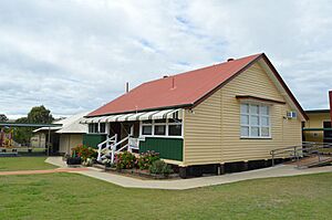
One important historical site in Roadvale is the Roadvale State School. It is located at 111 Roadvale Road. This school building is recognized for its special heritage.
Learning in Roadvale
Roadvale State School is a government primary school. It teaches boys and girls from Prep (the first year of school) up to Year 6. The school is located at 111 Roadvale Road. In 2018, there were 39 students attending the school.
There are no high schools in Roadvale itself. The closest government high school for older students is Boonah State High School, which is in Boonah to the south.
Local Spots
Roadvale has a pub where people can gather. There is also a small general store on the main street.
 | Emma Amos |
 | Edward Mitchell Bannister |
 | Larry D. Alexander |
 | Ernie Barnes |


