Wyaralong, Queensland facts for kids
Quick facts for kids WyaralongQueensland |
|||||||||||||||
|---|---|---|---|---|---|---|---|---|---|---|---|---|---|---|---|

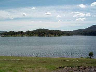
The opposite bank of the Wyaralong Dam is in Wyaralong
|
|||||||||||||||
| Population | 18 (2021 census) | ||||||||||||||
| • Density | 0.200/km2 (0.52/sq mi) | ||||||||||||||
| Postcode(s) | 4310 | ||||||||||||||
| Area | 90.1 km2 (34.8 sq mi) | ||||||||||||||
| Time zone | AEST (UTC+10:00) | ||||||||||||||
| Location |
|
||||||||||||||
| LGA(s) | Scenic Rim Region | ||||||||||||||
| State electorate(s) | Scenic Rim | ||||||||||||||
| Federal Division(s) | Wright | ||||||||||||||
|
|||||||||||||||
Wyaralong is a small rural area in the Scenic Rim Region of Queensland, Australia. It's known for its beautiful natural scenery and the large Wyaralong Dam. In 2021, the area had a very small population, with census data showing "no people or a very low population".
Contents
Exploring Wyaralong's Geography
Wyaralong is home to the impressive Wyaralong Dam. This dam was built across Teviot Brook, which is a stream that flows into the Logan River. The dam wall itself is partly in Wyaralong and partly in a nearby area called Allenview.
Wyaralong Dam and Lake
The water held back by the dam forms Lake Wyaralong. Most of this lake is within Wyaralong. However, some parts, including the public access area, are in Allenview. The dam wall is quite wide, stretching about 463.6 meters (1,521 feet). The area that collects water for the dam, called the catchment area, covers 546 square kilometers (211 square miles). The dam can hold a huge amount of water, up to 102,883 megalitres (about 27.2 billion US gallons).
Mountains and Roads
In the southern part of Wyaralong, you'll find Mount Moy. This mountain rises to 356 meters (1,168 feet) above sea level. The Beaudesert–Boonah Road (also known as State Route 90) passes through Wyaralong. It runs from the southeast to the south, going around the southern side of Lake Wyaralong.
Land Use in Wyaralong
Most of the land in Wyaralong is used for grazing animals, where they eat the natural plants. There are also some areas where trees are grown specifically for timber, known as plantation forestry.
A Look at Wyaralong's History
Wyaralong has a history that includes early schools and even a special use during wartime.
Early Schools in Wyaralong
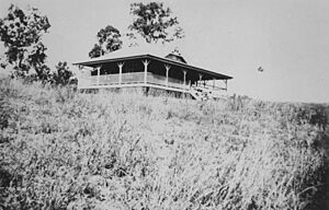
- Wyaralong Provisional School: This school first opened its doors on June 30, 1924. It was located in a cottage on the Wyaralong pastoral station, which was provided by Mr. and Mrs. Colin John Campbell Philp. However, it closed just five years later in 1929 because there weren't enough students.
- Wyaralong State School: A new school, Wyaralong State School, opened on February 14, 1938. The land for this school, about 3 acres (1.2 hectares), was donated by Colin Philp. Miss T. D. Dengle was the first teacher. The Minister for Public Instruction, Frank Cooper, officially opened the school on March 11, 1938. This school closed in 1949 but reopened in 1956. It finally closed for good on July 18, 1965. The school's location had to be changed because of the water from the dam.
Wartime Training
In 1940, the Wyaralong area was used for air gunnery practice. This was the first time such training exercises took place in Queensland.
Wyaralong Dam Completion
The modern Wyaralong Dam was completed in 2011. This major project changed the landscape and created Lake Wyaralong.
Population in Wyaralong
The population of Wyaralong has been very small. In 2016, there were 20 people living in the area. By 2021, the census reported that Wyaralong had "no people or a very low population." This means it's a very quiet and sparsely populated place.
Economy and Homesteads
The main economic activity in Wyaralong is related to farming, especially grazing. There are several homesteads, which are main houses on a farm or ranch, located throughout the area.
- Alanmere
- Banjora
- Glen Retreal
- The Overflow
- Wyaralong
Education Opportunities
There are no schools located directly within Wyaralong. Students living in the area typically travel to nearby towns for their education.
- Primary Schools: The closest primary schools are Roadvale State School in Roadvale (to the west), Gleneagle State School in Gleneagle (to the east), and Boonah State School in Boonah (to the south-west).
- Secondary Schools: For high school, students usually attend Boonah State High School in Boonah (to the south-west) or Beaudesert State High School in Beaudesert (to the east).
 | Madam C. J. Walker |
 | Janet Emerson Bashen |
 | Annie Turnbo Malone |
 | Maggie L. Walker |


