
Warrill View, Queensland facts for kids
Quick facts for kids Warrill ViewQueensland |
|||||||||||||||
|---|---|---|---|---|---|---|---|---|---|---|---|---|---|---|---|

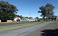
Cunningham Highway at Warrill View, 2015
|
|||||||||||||||

Warrill View
Location in Queensland
|
|||||||||||||||
| Population | 203 (2021 census) | ||||||||||||||
| • Density | 6.114/km2 (15.84/sq mi) | ||||||||||||||
| Postcode(s) | 4307 | ||||||||||||||
| Elevation | 65 m (213 ft) | ||||||||||||||
| Area | 33.2 km2 (12.8 sq mi) | ||||||||||||||
| Time zone | AEST (UTC+10:00) | ||||||||||||||
| Location |
|
||||||||||||||
| LGA(s) | Scenic Rim Region | ||||||||||||||
| State electorate(s) | Scenic Rim | ||||||||||||||
| Federal Division(s) | Wright | ||||||||||||||
|
|||||||||||||||
Warrill View is a small country town and area in the Scenic Rim Region of Queensland, Australia. It's a quiet place where many people live on farms. In 2021, about 203 people lived in Warrill View.
Contents
Where is Warrill View Located?
Warrill View is found in the Fassifern Valley, a rich farming area. A main road called the Cunningham Highway goes right through the town. A creek named Warrill Creek also flows nearby. This creek eventually joins the Bremer River.
A Glimpse into Warrill View's Past
How Did Warrill View Get Its Name?
The area around Warrill View was first explored in 1829 by a botanist named Allan Cunningham. He was a scientist who studied plants. From a small hill, he saw wide, flat lands. He decided to call these lands Laidley Plain. He named them after James Laidley, who was an important government official in Sydney at that time.
The town itself was known as Normanby from around 1859 until 1931. But there was another town called Normanby nearby, which caused a lot of confusion! To fix this, the town was renamed Warrill View. This name was already used for the local school and post office. The word Warrill comes from the name of the local creek. People believe it's an Aboriginal word that means water or stream.
Important Dates in Warrill View's History
- 1910: Warrill View State School opened its doors on September 15th.
- 1951: The Warrill View Baptist Church was started. It was moved from another place called Kulgun. The church was made of timber. It closed in 1975 and was sold in 1980.
What is the Population of Warrill View?
The number of people living in Warrill View has changed over the years:
- In 2011, there were 321 people.
- In 2016, the population was 240 people.
- In 2021, the number of people living in Warrill View was 203.
Historic Places to See
Warrill View has some special places that are protected because of their history. One of these is:
- Normanby Homestead, located on the Cunningham Highway. A homestead is a large house on a farm.
Learning in Warrill View
Warrill View State School is a government primary school for students from Prep (the first year of school) to Year 6. Both boys and girls go to this school. It is located at 7-19 Ipswich Street. In 2022, the school had 22 students.
There are no high schools directly in Warrill View. Students who want to go to secondary school usually travel to nearby towns. The closest government high schools are Rosewood State High School in Rosewood and Boonah State High School in Boonah.
Fun Things to See

Cunninghams Lookout is a great spot to visit. It's on the small hill where botanist Allan Cunningham first saw the wide plains and named them Laidley Plain. From here, you can see amazing views of the area! It's located off the Rosewood Warrill View Road.
Images for kids
-
Cunningham Highway at Warrill View, 2015
-
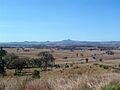
View towards the town as seen from Cunninghams Lookout, 2011
