Silverdale, Queensland facts for kids
Quick facts for kids SilverdaleQueensland |
|||||||||||||||
|---|---|---|---|---|---|---|---|---|---|---|---|---|---|---|---|

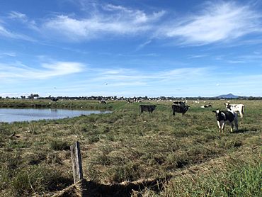
Paddocks along Kengoon Road, 2015
|
|||||||||||||||
| Population | 112 (2021 census) | ||||||||||||||
| • Density | 2.887/km2 (7.48/sq mi) | ||||||||||||||
| Postcode(s) | 4307 | ||||||||||||||
| Area | 38.8 km2 (15.0 sq mi) | ||||||||||||||
| Time zone | AEST (UTC+10:00) | ||||||||||||||
| Location |
|
||||||||||||||
| LGA(s) | Scenic Rim Region | ||||||||||||||
| State electorate(s) | Scenic Rim | ||||||||||||||
| Federal Division(s) | Wright | ||||||||||||||
|
|||||||||||||||
Silverdale is a small, quiet area in the countryside of Queensland, Australia. It's part of the Scenic Rim Region. In 2021, about 112 people lived in Silverdale.
Contents
Where is Silverdale?
Silverdale is located in the Fassifern Valley. This valley is known for its beautiful landscapes.
Natural Boundaries
The western edge of Silverdale is marked by Warroolaba Creek. On the eastern side, you'll find Warrill Creek. Warrill Creek flows into the Bremer River.
Roads and Land
The Cunningham Highway passes through Silverdale. It enters from the north, near Warrill View. It then leaves to the south, heading towards Kalbar. The land in Silverdale goes from about 60 meters to 210 meters above sea level. Most of the land is used for grazing animals like cattle.
A Look at Silverdale's History
Silverdale has a simple but interesting history, especially when it comes to its school.
The First School
In July 1909, people in Silverdale met to talk about opening a local school. They thought about 32 students would attend. By November 1909, plans were made to build the school. The school officially opened on May 23, 1910.
School Closure
Silverdale State School closed its doors on January 28, 1963. After that, students went to Engelsburg State School. This school is now known as Kalbar State School, located in Kalbar. The old school building was at 5382 Cunningham Highway.
Who Lives in Silverdale?
The number of people living in Silverdale has changed a bit over the years.
- In 2011, Silverdale's population was counted with the nearby area of Munbilla. Together, they had 434 people.
- By 2016, Silverdale had a population of 120 people on its own.
- In the most recent count in 2021, 112 people lived in Silverdale.
Learning and Education
There are no schools directly in Silverdale today. However, students can easily go to schools in nearby towns.
Primary Schools Nearby
For younger students, the closest government primary schools are:
- Warrill View State School, located north in Warrill View.
- Kalbar State School, found south in Kalbar.
- Aratula State School, to the south-west in Aratula.
High Schools Nearby
Older students can attend government secondary schools like:
- Boonah State High School, located south-east in Boonah.
- Rosewood State High School, to the north in Rosewood.
Local Facilities
Silverdale has a special facility that helps with farming.
Cattle Tick Clearing
Silverdale is home to one of Queensland's many cattle tick clearing facilities. These places help keep cattle healthy by removing tiny pests called ticks.
Fun Events
Even though Silverdale is small, it hosts an important event for the local community.
Annual Cattle Show
Each year, Silverdale holds its Annual Silverdale Show and Sale of cattle. This event is a chance for farmers to show off their cattle. It's also a place where cattle can be bought and sold.
 | Calvin Brent |
 | Walter T. Bailey |
 | Martha Cassell Thompson |
 | Alberta Jeannette Cassell |


