
National Register of Historic Places listings in Belknap County, New Hampshire facts for kids

Have you ever wondered about the old buildings and special places in your town? Many of them have amazing stories! In Belknap County, New Hampshire, there are many historic places that are so important, they've been added to a special list called the National Register of Historic Places. This list helps protect these places so people can enjoy and learn from them for many years to come.
Belknap County is home to 46 properties and areas that are on this important list. Each one tells a part of New Hampshire's history. Let's explore some of these cool spots!
Contents
Exploring Historic Places in Belknap County, New Hampshire
Belknap County is full of interesting places that have been recognized for their historical value. These spots include old train stations, beautiful churches, public libraries, and even ancient Native American sites. They all help us understand what life was like long ago.
Historic Buildings and Structures
Many buildings in Belknap County have been preserved because of their unique architecture or the important events that happened there.
Old Train Stations and Mills
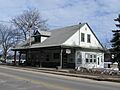
- Alton Bay Railroad Station: Located in Alton, this old train station was added to the list in 1983. It reminds us of a time when trains were a main way to travel and transport goods.
- Belknap-Sulloway Mill: Found in Laconia, this mill was listed in 1971. It's now the Belknap Mill Museum, where you can learn about the area's industrial past. Mills like this were once very important for making things.
- Busiel-Seeburg Mill: Also in Laconia, this mill was listed on the same day as the Belknap-Sulloway Mill. These mills show how important manufacturing was to Laconia's growth.
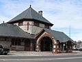
- Laconia Passenger Station: This train station in Laconia was listed in 1982. It served as a busy hub for people traveling by train.
Churches and Meeting Houses
Churches and meeting houses were often central to community life. They served as places of worship and community gatherings.
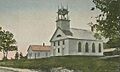
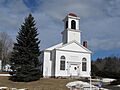
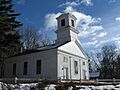
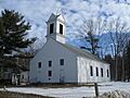
- Bay Meeting House and Vestry: In Sanbornton, this historic meeting house was listed in 1984. It's a great example of early American community buildings.
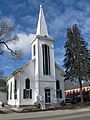
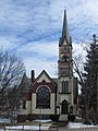
- Centre Congregational Church: This church in Gilmanton was added to the list in 1983. It has been a spiritual center for the community for a long time.
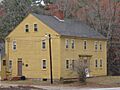
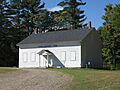
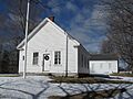
- Dana Meeting House: Located in New Hampton, this meeting house was listed in 1984. These buildings often hosted town meetings and other important events.
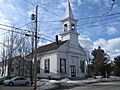
- Evangelical Baptist Church: This church in Laconia was listed in 1985. Its architecture and history make it a special landmark.
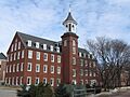
- First Baptist Church of Gilmanton: Another historic church in Gilmanton, listed in 1989.
- First Congregational Church: In Alton, this church was listed in 1990.
- First Free Will Baptist Church in Meredith: This church in Meredith was listed in 1986.
- First Freewill Baptist Church: Located in East Alton, this church was listed in 1978.
- New Hampton Community Church: This church in New Hampton was listed in 1985.
- Second Free Baptist Church: Another historic church in Alton, listed in 1990.
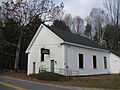
- Smith Meeting House: In Gilmanton, this meeting house was listed in 1998.
- United Baptist Church of Lakeport: This church in Lakeport (part of Laconia) was listed in 1985.
Libraries and Public Buildings
Libraries are important centers for learning and community. Many old libraries are beautiful and historic.
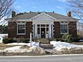
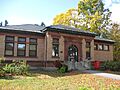
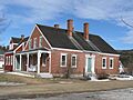
- Belmont Public Library: In Belmont, this library was listed in 1985.
- Oscar Foss Memorial Library: Located in Barnstead, this library was listed in 1985.
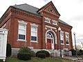
- Gale Memorial Library: This library in Laconia was listed in 1985.
- Gilmanton Ironworks Library: In Gilmanton, this library was listed in 1989.
- Gordon-Nash Library: This library in New Hampton was listed in 1988.
- Ossian Wilbur Goss Reading Room: Located in Lakeport (Laconia), this reading room was listed in 1986.
- Meredith Public Library: In Meredith, this library was listed in 1984.
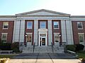
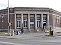
- Federal Building: This building in Laconia was listed in 2011. It's an important government building.
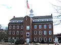
- Laconia District Court: This court building in Laconia was listed in 1982.
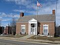
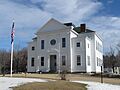
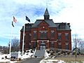
- New Hampton Town House: This town house in New Hampton was listed in 1998. It's where local government business takes place.
- US Post Office-Laconia Main: This post office in Laconia was listed in 1986.
Unique Homes and Other Structures
Some homes are so special they become historic landmarks.
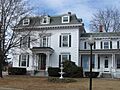
- John W. Busiel House: This house in Laconia was listed in 1994. It's a great example of historic residential architecture.
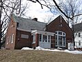
- District No. 9 Schoolhouse: In Gilford, this old schoolhouse was listed in 2000. Imagine learning in a classroom like this!
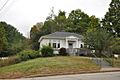
- House by the Side of the Road: This unique house in Tilton was listed in 1980.
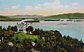
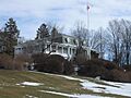
- Kimball Castle: Located in Gilford, this castle-like building was listed in 1982. It's a fascinating and unusual piece of architecture.
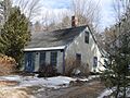
- Washington Mooney House: This house in New Hampton was listed in 1997.
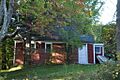
- John J. Morrill Store: In Gilford, this old store was listed in 1980.
- Benjamin Rowe House: This house in Gilford was listed in 2008.
- Charles E. Tilton Mansion: This grand mansion in Tilton was listed in 1982.
Historic Districts and Archeological Sites
Sometimes, a whole area or a specific natural feature is important enough to be listed.
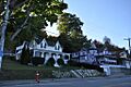
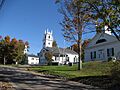
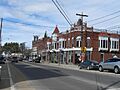
- Centre Harbor Village Historic District: This district in Center Harbor was listed in 1983. It includes many historic buildings that together tell a story.
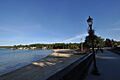
- Endicott Rock: Located in Weirs Beach (Laconia), this rock was listed in 1980. It's a famous landmark with historical significance.
- Lochmere Archeological District: This large area in Tilton, listed in 1982, contains many ancient Native American artifacts. It helps us learn about the first people who lived here.
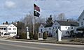
- Monument Square Historic District: This district in Alton was listed in 1984. It's a central part of the town with many historic buildings.
- New Hampshire Veterans' Association Historic District: North of Laconia in Weirs Beach, this district was listed in 1980. It honors veterans and their history.
- Sanbornton Square Historic District: This district in Sanbornton was listed in 1980.
- Tilton Downtown Historic District: This district in Tilton was listed in 1983. It shows what a bustling downtown looked like in the past.
- Tilton Island Park Bridge: This bridge over the Winnipesaukee River in Tilton was listed in 1980. Bridges are important for connecting communities.
- The Weirs: Near the outlet of Lake Winnipesaukee in Weirs Beach (Laconia), this is a major Native American archeological site, listed in 1975. It's a very important place for understanding ancient cultures.
These are just some of the amazing historic places in Belknap County. Each one is a piece of history, waiting for you to discover its story!
Images for kids
-
Alton Bay Railroad Station
-
Bay Meeting House and Vestry
-
Belknap-Sulloway Mill
-
Belmont Public Library
-
John W. Busiel House
-
Busiel-Seeburg Mill
-
Centre Congregational Church
-
Centre Harbor Village Historic District
-
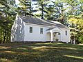
Dana Meeting House
-
District No. 9 Schoolhouse
-
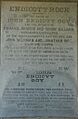
Endicott Rock
-
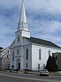
Evangelical Baptist Church
-
Federal Building
-
First Baptist Church of Gilmanton
-
First Congregational Church
-
First Free Will Baptist Church in Meredith
-
First Freewill Baptist Church
-
Oscar Foss Memorial Library
-
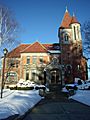
Gale Memorial Library
-
Gilmanton Academy
-
Gilmanton Ironworks Library
-
Gordon-Nash Library
-
Ossian Wilbur Goss Reading Room
-
House by the Side of the Road
-
Kimball Castle
-
Laconia District Court
-
Laconia Passenger Station
-

Lochmere Archeological District
-
Meredith Public Library
-
Monument Square Historic District
-
Washington Mooney House
-
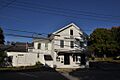
John J. Morrill Store
-
New Hampshire Veterans' Association Historic District
-

New Hampton Community Church
-
New Hampton Town House
-
Benjamin Rowe House
-
Sanbornton Square Historic District
-
Second Free Baptist Church
-
Smith Meeting House
-
Tilton Downtown Historic District
-
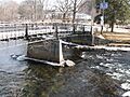
Tilton Island Park Bridge
-
Charles E. Tilton Mansion
-
United Baptist Church of Lakeport
-
US Post Office-Laconia Main
-
The Weirs


