
National Register of Historic Places listings in Jefferson County, West Virginia facts for kids

Welcome to Jefferson County, West Virginia! This area is full of amazing old buildings and places that are super important to history. This page lists all the cool spots in Jefferson County that are on the National Register of Historic Places. Think of it like a special list of places that the United States government wants to protect because they tell important stories about our past.
There are 80 different places and areas in Jefferson County on this list. One of them is even more special, called a National Historic Landmark! This means it's one of the most important historical sites in the whole country. You can even find some of these places on a map using their exact location coordinates!
|
Barbour - Berkeley - Boone - Braxton - Brooke - Cabell - Calhoun - Clay - Doddridge - Fayette - Gilmer - Grant - Greenbrier - Hampshire - Hancock - Hardy - Harrison - Jackson - Jefferson - Kanawha - Lewis - Lincoln - Logan - Marion - Marshall - Mason - McDowell - Mercer - Mineral - Mingo - Monongalia - Monroe - Morgan - Nicholas - Ohio - Pendleton - Pleasants - Pocahontas - Preston - Putnam - Raleigh - Randolph - Ritchie - Roane - Summers - Taylor - Tucker - Tyler - Upshur - Wayne - Webster - Wetzel - Wirt - Wood - Wyoming |
Exploring Jefferson County's Historic Places
Jefferson County is home to many historic buildings and areas. These places help us understand what life was like long ago. Each one has a unique story to tell.
Homes and Buildings with History
Many of the places on the list are old houses or important buildings. They show us different styles of architecture and how people lived in the past.
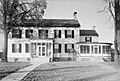
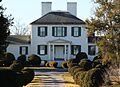
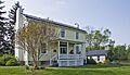
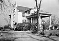
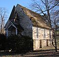
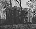
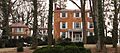
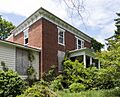
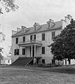
- Allstadt House and Ordinary: This old house and inn is near Harpers Ferry. It was listed in 1985.
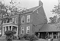
- Altona: Located west of Charles Town, this historic spot was added to the list in 1995.
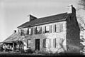
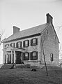
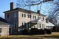
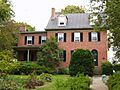
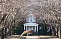
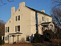
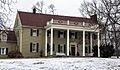
- Beall-Air: Found west of Halltown, this property became historic in 1973.
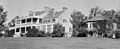
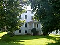
- Beverley: Near Charles Town, this site was recognized in 1987.
- Blakeley: Another historic place in Charles Town, listed in 1982.
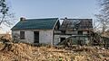
- The Bower: This property in Leetown was added to the list in 1982.
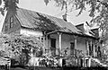
- Peter Burr House: A very old house in Shenandoah Junction, listed in 1982.
- Cedar Lawn: West of Charles Town, this property was recognized in 1974.
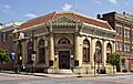
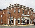
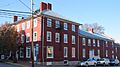
- Charles Town Mining, Manufacturing, and Improvement Company Building: An important building in Ranson, listed in 2001.
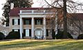
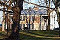
- Claymont Court: Southwest of Charles Town, this grand place was added in 1973.
- Cold Spring: South of Shepherdstown, recognized in 1973.
- Cool Spring Farm: A farm in Charles Town, listed in 2007.
- Elmwood: Another historic spot south of Shepherdstown, listed in 1973.
- Elmwood-on-the-Opequon: In Kearneysville, this property was added in 2006.
- Fruit Hill: Located in Shepherdstown, recognized in 1988.
- Gibson-Todd House: A house in Charles Town, listed in 1983.
- Glenburnie: In Shenandoah Junction, this property was added in 1988.
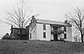
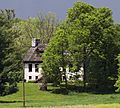
- Harewood: West of Charles Town, recognized in 1973.
- Hazelfield: Near Shenandoah Junction, listed in 1976.
- The Hermitage: A historic place in Charles Town, added in 1993.
- Hillside: Another Charles Town property, listed in 1985.
- Hopewell: Northeast of Bloomery, recognized in 1994.
- Jacks-Manning Farm: A farm in Charles Town, listed in 1984.
- Jefferson County Alms House: Southeast of Leetown, added in 1995.
- Lee-Longsworth House: A house in Harpers Ferry, listed in 1985.
- Captain William Lucas and Robert Lucas House: In Shepherdstown, recognized in 1982.
- James Marshall House: Another historic house in Shepherdstown, listed in 1988.
- Media Farm: North of Charles Town, added in 1994.
- Morgan-Bedinger-Dandridge House: Southwest of Shepherdstown, recognized in 1983.
- New Opera House: An important building in Charles Town, listed in 1978.
- Potomac Mills: In Shepherdstown, added in 2014.
- Prato Rio: In Leetown, recognized in 1973.
- Richwood Hall: West of Charles Town, listed in 1973.
- Rion Hall: East of Charles Town, added in 1982.
- Rock Spring: In Shepherdstown, recognized in 2008.
- Rose Hill Farm: Southeast of Shepherdstown, listed in 1990.
- Rumsey Hall: In Shepherdstown, added in 1973.
- St. Peter's Roman Catholic Church: A church in Harpers Ferry, recognized in 1973.
- Shannondale Springs: South of Shannondale, listed in 1998.
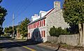
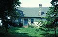
- Shepherd's Mill: An old mill in Shepherdstown, added in 1971.
- Strider Farm: A farm in Harpers Ferry, recognized in 1988.
- Tackley Farm: East of Shenandoah Junction, listed in 1994.
- Van Swearingen-Shepherd House: North of Shepherdstown, added in 1983.
- Charles Washington House: In Charles Town, recognized in 1973.
- White House Farm: In Summit Point, listed in 1979.
- Woodbury: In Leetown, added in 1974.
- Woodlawn: In Kearneysville, recognized in 2000.
- Robert Worthington House: West of Charles Town, listed in 1973.
- York Hill: In Shenandoah Junction, added in 2006.
Important Districts and Areas
Some listings are not just single buildings but entire historic districts. These districts include many buildings that together show the history of a town or area.
- Boidstones Place: A historic district in Shepherdstown, listed in 1999.
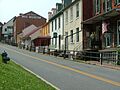
- Downtown Charles Town Historic District: This area covers many streets in Charles Town, recognized in 1997.
- Falling Spring-Morgan's Grove: A district in Shepherdstown, added in 1989.
- Gap View Farm: Between Charles Town and Shenandoah Junction, listed in 1997.
- Harpers Ferry Historic District: A large historic area in Harpers Ferry, recognized in 1979.
- Harpers Ferry National Historical Park: This is a very important park where the Shenandoah and Potomac rivers meet. It was first listed in 1966 and had a boundary increase in 2016.
- Middleway Historic District: An area in Middleway, added in 1980.
- Morgan's Grove: A district in Shepherdstown, recognized in 1999.
- Old Charles Town Historic District: This large district covers many parts of Charles Town, listed in 2000.
- Rellim Farm: A farm district in Kearneysville, added in 1998.
- Ripon Lodge: A historic district in Rippon, recognized in 1998.
- Rockland: A district in Shepherdstown, listed in 1990.
- Shepherdstown Historic District: This area covers the historic heart of Shepherdstown, recognized in 1973.
- South Charles Town Historic District: This district covers several streets in Charles Town, added in 2009.
- Sunnyside Farm: A farm district in Kearneysville, recognized in 1999.
Other Notable Historic Sites
Some places are important for other reasons, like their connection to transportation or education.
- B & O Railroad Potomac River Crossing: This historic railroad crossing is at the meeting point of the Shenandoah and Potomac Rivers in Harpers Ferry. It was listed in 1978.
- Halltown Colored Free School: This school in Halltown was important for African American education. It was recognized in 2004.
- Halltown Union Colored Sunday School: Another important educational and community building in Halltown, listed in 1984.
- Feagans' Mill Complex: This mill complex near Charles Town was added to the list in 2017.
- William Grubb Farm: A historic farm near Charles Town, listed in 1991.
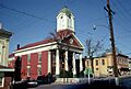
- Jefferson County Courthouse: The main courthouse in Charles Town, recognized in 1973.
- Traveller's Rest: This site in Kearneysville is a National Historic Landmark, meaning it's super important! It was listed in 1972.
These places help us remember and learn about the rich history of Jefferson County. Visiting them is like taking a step back in time!
Images for kids
-
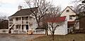
The historic Allstadt House and Ordinary.
-
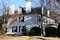
Altona, a historic property in West Virginia.
-
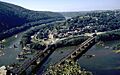
The B & O Railroad Potomac River Crossing at Harpers Ferry.
-
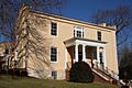
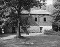
Beall-Air, a historic home.
-
Beverley, near Charles Town.
-
Blakeley, a historic site.
-
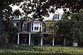
The Bower, a historic property.
-
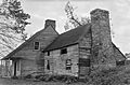
The Peter Burr House.
-
Cedar Lawn, a historic estate.
-
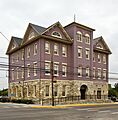
The Charles Town Mining, Manufacturing, and Improvement Company Building.
-
Claymont Court, a grand historic home.
-
Cold Spring, near Shepherdstown.
-
Cool Spring Farm.
-
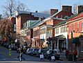
Downtown Charles Town Historic District.
-
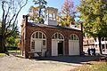
Duffields Depot.
-
Elmwood, near Shepherdstown.
-
Falling Spring-Morgan's Grove.
-
Gap View Farm.
-
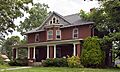
The Gibson-Todd House.
-
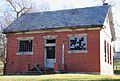
The Halltown Colored Free School.
-
The Halltown Union Colored Sunday School.
-
Harewood, a historic property.
-
Harpers Ferry Historic District.
-
Harpers Ferry National Historical Park.
-
The Jefferson County Courthouse.
-
The Lee-Longsworth House.
-
Captain William Lucas and Robert Lucas House.
-
Middleway Historic District.
-
Morgan's Grove.
-
The Morgan-Bedinger-Dandridge House.
-
The New Opera House.
-
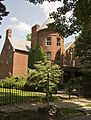
Prato Rio, a historic home.
-
Richwood Hall.
-
Rion Hall.
-
Rock Spring.
-
Rose Hill Farm.
-
Rumsey Hall.
-
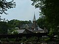
St. Peter's Roman Catholic Church.
-
Shepherd's Mill.
-
Shepherdstown Historic District.
-
South Charles Town Historic District.
-
Tackley Farm.
-
Traveller's Rest.
-
The Van Swearingen-Shepherd House.
-

The Charles Washington House.
-
White House Farm.
-
Woodbury.
-
The Robert Worthington House.
-
York Hill.


