
National Register of Historic Places listings in South Side Chicago facts for kids
There are 95 amazing places in South Side Chicago that are listed on the National Register of Historic Places. This means they are super important because of their history or special design! Chicago has over 350 such places in total, and many are right here on the South Side.
For this article, the South Side means the area west of Lake Michigan, south of 26th Street, and the Chicago Sanitary and Ship Canal, all the way to the city's southern edge.
These special places are found across 19 of Chicago's 77 different neighborhoods. Let's explore some of them!
Contents
- What is the National Register of Historic Places?
- Homes of Important People
- Historic Parks and Green Spaces
- Important Buildings and Districts
- Chicago Bee Building
- Eighth Regiment Armory
- The Forum
- Goldblatt Bros. Department Store
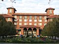
- Illinois Institute of Technology Academic Campus
- Old Stone Gate of Chicago Union Stockyards
- Pullman Historic District
- Site of First Self-Sustaining Nuclear Reaction
- Room 405, George Herbert Jones Laboratory
- S.R. Crown Hall
- South Shore Country Club
- German submarine U-505
- Victory Monument
- Wabash Avenue YMCA
- Other Notable Listings
- Images for kids
What is the National Register of Historic Places?
The National Register of Historic Places (NRHP) is the official list of places in the United States that are worth saving because of their historical importance. When a place is on this list, it means it has played a big role in American history, architecture, archaeology, engineering, or culture.
- NRHP-listed: This means a single building or place is on the list.
- Historic District: This means a whole area with many buildings is important together.
- National Historic Landmark: These are extra special places that are important to the entire country, not just Illinois!
Homes of Important People
Many famous people lived in the South Side of Chicago, and their homes are now protected!
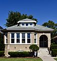
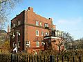
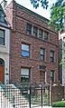
Robert S. Abbott House

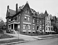
Located in the Grand Boulevard neighborhood, this house at 4742 S. Dr. Martin Luther King Jr. Drive was the home of Robert Sengstacke Abbott. He was a very important person who started The Chicago Defender newspaper. This newspaper was a big voice for African Americans, especially during the Great Migration when many moved from the South to cities like Chicago. His home became a National Historic Landmark in 1976.
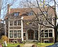
Arthur H. Compton House

In Hyde Park, at 5637 S. Woodlawn Avenue, you'll find the home of Arthur H. Compton. He was a famous scientist who won a Nobel Prize for his work in physics. His house became a National Historic Landmark in 1976.
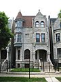
Oscar Stanton De Priest House

Another important home in Grand Boulevard is the Oscar Stanton De Priest House at 4536-4538 S. Dr. Martin Luther King Jr. Drive. Oscar Stanton De Priest was the first African American to be elected to Congress from a Northern state. His house was recognized as a National Historic Landmark in 1975.
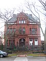
Frank R. Lillie House
.jpg)
The Frank R. Lillie House at 5801 S. Kenwood Avenue in Hyde Park belonged to Frank R. Lillie, a well-known biologist. His home was added to the National Register in 1976.
Robert A. Millikan House

Also in Hyde Park, at 5605 S. Woodlawn Avenue, is the Robert A. Millikan House. Robert A. Millikan was another Nobel Prize-winning physicist. His house became a National Historic Landmark in 1976.
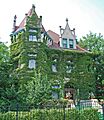
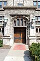
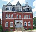
Ida B. Wells-Barnett House
.JPG)
The home of Ida B. Wells-Barnett at 3624 S. Dr. Martin Luther King Jr. Drive in Douglas is a very important site. She was a brave journalist and activist who fought for civil rights and women's right to vote. Her house was made a National Historic Landmark in 1974.
Dr. Daniel Hale Williams House

In Grand Boulevard, at 445 E. 42nd Street, stands the Dr. Daniel Hale Williams House. Daniel Hale Williams was a pioneering African American surgeon who performed one of the first successful open-heart surgeries. His house was listed in 1975.
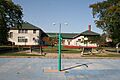
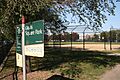
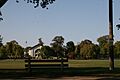
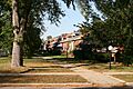
Historic Parks and Green Spaces
Chicago's South Side is home to many beautiful and historic parks, designed for everyone to enjoy.
Armour Square Park

Armour Square Park, located in the Armour Square neighborhood, is a historic district bounded by W. 33rd Street, W. 34th Place, S. Wells Street, and S. Shields Avenue. It was added to the National Register in 2003.
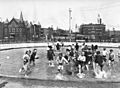
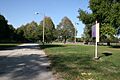
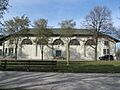
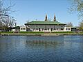
Calumet Park

Calumet Park at 9801 S. Avenue G in the East Side neighborhood is another historic park. It was listed in 2003 and provides a great space for recreation and community activities.
Cornell Square

Cornell Square at 1809 W. 50th Street in New City is a historic park that joined the National Register in 2005. These parks were often designed to offer green spaces and community centers for city residents.
Davis Square

Also in New City, Davis Square is roughly bounded by W. 44th Street, W. 45th Street, S. Marshfield Avenue, and S. Hermitage Avenue. It became a historic district in 2003.
Fuller Park

Fuller Park at 331 W. 45th Street in the Fuller Park neighborhood was listed in 2002. These parks are important examples of early 20th-century urban planning, providing much-needed green spaces in busy city areas.
Grand Crossing Park

Grand Crossing Park at 7655 S. Ingleside Avenue in Greater Grand Crossing was added to the National Register in 2006.
Hamilton Park

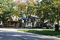
In Englewood, Hamilton Park at 513 W. 72nd Street became a historic district in 1995.
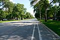
Jackson Park and Midway Plaisance

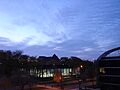
The Jackson Park Historic Landscape District and Midway Plaisance is a very large and important area. It includes Jackson and Washington Parks, and the Midway Plaisance roadway. These parks were designed by famous landscape architects and played a key role in the 1893 World's Columbian Exposition. This district was listed in 1972.
Palmer Park

Palmer Park at 201 E. 111th Street in Roseland was recognized as a historic district in 2007.
Sherman Park

Sherman Park in New City, bounded by W. 52nd Street, S. Racine Avenue, W. Garfield Boulevard, and S. Loomis Street, became a historic district in 1990.
Trumbull Park

Trumbull Park at 2400 E. 105th Street in South Deering was listed in 1995.
Washington Park

Washington Park at 5531 S. Dr. Martin Luther King Jr. Drive in the Washington Park neighborhood was added to the National Register in 2004. It's a large and beautiful park with a rich history.
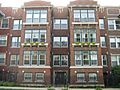
Important Buildings and Districts
The South Side has many buildings and areas that tell important stories about Chicago's past.
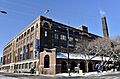
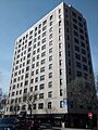
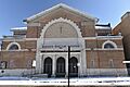
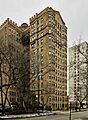
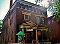
Chicago Bee Building

The Chicago Bee Building at 3647-3655 S. State Street in Douglas was listed in 1986. This building was home to another important African American newspaper, the Chicago Bee.
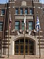
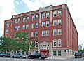
Eighth Regiment Armory

The Eighth Regiment Armory at 3533 S. Giles Avenue in Douglas is a significant building. It was home to the first African American National Guard unit in the United States. It was listed in 1986.
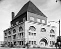
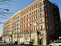
The Forum
.jpg)
The Forum at 318-328 E. 43rd Street in Grand Boulevard is a historic building that was added to the National Register in 2019. It's an important example of early 20th-century architecture and community gathering spaces.
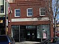
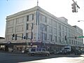
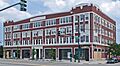
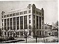
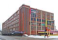
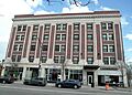
Goldblatt Bros. Department Store
.jpg)
The Goldblatt Bros. Department Store at 4700 S. Ashland Avenue in New City was a major department store. It was listed in 2006, representing an important part of Chicago's retail history.
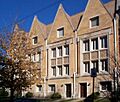
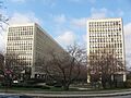
Illinois Institute of Technology Academic Campus

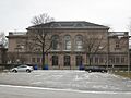
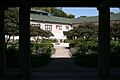
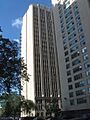
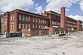
The Illinois Institute of Technology Academic Campus is a large historic district in Douglas. It's roughly bounded by 31st Street, State Street, 35th Street, and the Dan Ryan Expressway. This campus is famous for its modern architecture, especially buildings designed by Ludwig Mies van der Rohe. It became a historic district in 2005.
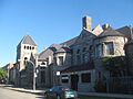
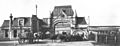
Old Stone Gate of Chicago Union Stockyards

The Old Stone Gate of Chicago Union Stockyards at W. Exchange Avenue & S. Peoria Street in New City is a very important landmark. The Union Stockyards were once the center of Chicago's meatpacking industry, which was a huge part of the city's economy. This gate is a reminder of that history and was made a National Historic Landmark in 1972.
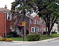
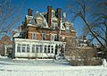
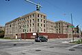
Pullman Historic District
.jpg)
The Pullman Historic District is a large and unique area in the Pullman neighborhood. It was one of the first planned industrial communities in the United States, built by George Pullman for his railroad car factory workers. This entire district is a National Historic Landmark, recognized in 1969.
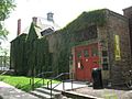
Site of First Self-Sustaining Nuclear Reaction

This site, located on S. Ellis Avenue between E. 56th Street and 57th Street in Hyde Park, is incredibly important to science history. It's where the first controlled, self-sustaining nuclear chain reaction happened in 1942, as part of the Manhattan Project. This event changed the world! It was designated a National Historic Landmark in 1966.
Room 405, George Herbert Jones Laboratory

Located at the University of Chicago on S. Ellis Avenue between E. 57th Street and 58th Street in Hyde Park, Room 405 of the George Herbert Jones Laboratory is where the element Plutonium was first discovered. This discovery was a major scientific breakthrough. It became a National Historic Landmark in 1967.
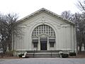
S.R. Crown Hall

S.R. Crown Hall at 3360 S. State Street in Douglas is a famous building on the Illinois Institute of Technology campus. It was designed by the renowned architect Ludwig Mies van der Rohe and is considered a masterpiece of modern architecture. It was made a National Historic Landmark in 2001.
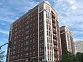
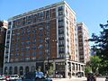
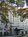
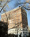
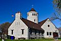
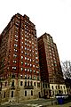
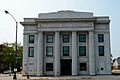
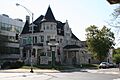
South Shore Country Club

The South Shore Country Club at 7059 S. South Shore Drive in South Shore was once a fancy private club. Today, it's the South Shore Cultural Center, a beautiful public park and cultural venue. It was listed in 1975.
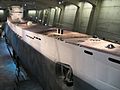
German submarine U-505

The German submarine U-505 is a real submarine from World War II, now located in Jackson Park at the Museum of Science and Industry. It was captured by the U.S. Navy during the war and is a rare example of a captured enemy submarine. It became a National Historic Landmark in 1989.
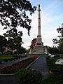
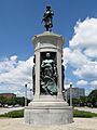
Victory Monument

The Victory Monument at E. 35th Street and S. Dr. Martin Luther King Jr. Drive in Douglas honors the Eighth Regiment of the Illinois National Guard, an African American unit that served bravely in World War I. It was listed in 1986.
Wabash Avenue YMCA

The Wabash Avenue YMCA at 3763 S. Wabash Avenue in Douglas was a very important place for African Americans during the early 20th century. It provided housing, education, and community support when many other places were segregated. It was listed in 1986.
Other Notable Listings
There are many other interesting places on the South Side's historic list!
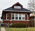
- Auburn Gresham Bungalow Historic District: This district in Auburn Gresham (listed 2012) is part of a larger effort to recognize Chicago's unique bungalow-style homes.
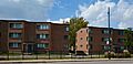
- Belmonte Flats: An apartment building in Grand Boulevard (listed 1998).
- Brainerd Bungalow Historic District: Another bungalow district in Washington Heights (listed 2016).
- Central Manufacturing District Historic Districts: These two districts in Bridgeport, McKinley Park, and New City (listed 2015, 2016) were important industrial areas.
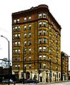
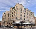
- Chicago Beach Hotel: A historic hotel in Hyde Park (listed 1986).
- Chrysler Village: A unique housing development in Clearing (listed 2014).
- Hotel Del Prado: Another historic hotel in Hyde Park (listed 1986).
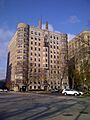
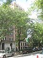
- Hyde Park-Kenwood Historic District: A large district covering parts of Hyde Park and Kenwood (listed 1979), known for its beautiful homes and architecture.
- Promontory Apartments and Promontory Point: Both in Hyde Park (listed 1996, 2018), these are important architectural and natural features along the lakefront.
- Ridge Historic District: A large district in Beverly and Morgan Park (listed 1976), known for its unique ridge landscape and historic homes.
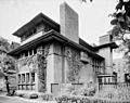
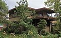
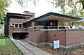
- Frederick C. Robie House: A famous house designed by Frank Lloyd Wright in Hyde Park (listed 1966). It's a National Historic Landmark and a great example of Prairie Style architecture.
- Rosenwald Apartment Building: A large apartment complex in Grand Boulevard (listed 1981) that provided housing for African Americans.
- Schulze Baking Company Plant: A historic bakery building in Washington Park (listed 1982).
- South Shore Bungalow Historic District: Another area of historic bungalows in South Shore (listed 2008).
- Stony Island Trust and Savings Bank Building: A unique bank building in South Shore (listed 2013).
- West Chatham Bungalow Historic District: More historic bungalows in Chatham (listed 2010).
These are just some of the many fascinating places on the National Register of Historic Places in South Side Chicago. Each one helps us understand the rich history and culture of this vibrant part of the city!
Images for kids
-
Robert S. Abbott House
-
Armour Square
-
Auburn Gresham Bungalow Historic District
-
Belmonte Flats
-
Brainerd Bungalow Historic District
-
Calumet Park Fieldhouse
-
Central Manufacturing District-Original East Historic District
-
Central Manufacturing District–Pershing Road Development Historic District
-
Chicago Beach Hotel
-
Chicago Bee Building
-
Chicago Park Boulevard System Historic District
-
Chrysler Village
-
Arthur H. Compton House
-
Cornell Square
-
Davis Square
-
Oscar Stanton De Priest House
-
Stephen A. Douglas Tomb
-
East Park Towers
-
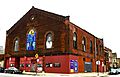
Ebenezer Missionary Baptist Church
-
Eighth Regiment Armory
-
Site of First Self-Sustaining Nuclear Reaction
-
Flamingo-on-the-Lake Apartments
-
The Forum
-
Four Nineteen Building
-
Fuller Park
-
Garden Homes Historic District
-
Goldblatt Bros. Department Store
-
Grand Crossing Park
-
John W. Griffiths Mansion
-
Hamilton Park
-
Anton E. Hanson House
-
Isadore H. Heller House
-
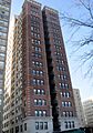
Charles Hitchcock Hall
-
Hotel Del Prado
-
Hotel Windermere East
-
Hyde Park-Kenwood Historic District
-
Illinois Institute of Technology Academic Campus
-
Midway Plaisance
-
Jackson Shore Apartments
-
Jeffery–Cyril Historic District
-
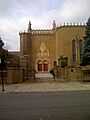
Kehilath Anshe Ma'ariv Synagogue
-
Sydney Kent House
-
Kenwood Evangelical Church
-
Lake-Side Terrace Apartments
-
Frank R. Lillie House
-
Mayfair Apartments
-
Allan Miller House
-
Robert A. Millikan House
-
The Narragansett
-
Old Stone Gate of Chicago Union Stockyards
-
Overton Hygienic Building
-
Anthony Overton Elementary School
-
Palmer Park Fieldhouse
-
Parkway Garden Homes
-
Poinsettia Apartments
-
Promontory Apartments
-
Promontory Point
-
Pullman Historic District
-
Ridge Historic District
-
Frederick C. Robie House
-
Martin Roche-John Tait House
-
Robert Roloson Houses
-
George Herbert Jones Laboratory
-
Rosenwald Apartment Building
-

S.R. Crown Hall
-
St. Thomas Church and Convent
-
Schulze Baking Company Plant
-
Sherman Park
-
Shoreland Hotel
-
Shoreline Apartments
-
South Park Manor Historic District
-
South Shore Beach Apartments
-
South Shore Bungalow Historic District
-
South Shore Country Club
-
South Side Community Art Center
-
Spiegel Office Building
-
Stony Island Trust and Savings Bank Building
-
Strand Hotel
-
Sutherland Hotel
-
Swift House
-
Lorado Taft Midway Studios
-
Trumbull Park Fieldhouse
-
U-505 (IX C U-Boat)
-
Unity Hall
-
University Apartments
-
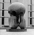
Victory Sculpture
-
Wabash Avenue YMCA
-
Washington Park
-
Ida B. Wells-Barnett House
-
West Chatham Bungalow Historic District
-
West Pullman Elementary School
-
Dr. Daniel Hale Williams House
-
The Yale


.jpg)


_and_North_elevations_-_HABS_ILL,16-CHIG,48-1.jpg)


.jpg)


.jpg)


.jpg)

.jpg)


.jpg)


.JPG)


