
New York State Route 308 facts for kids
Quick facts for kids
|
||||
|---|---|---|---|---|
| Lua error in Module:Infobox_road/map at line 15: attempt to index field 'wikibase' (a nil value).
Map of the Kingston area with NY 308 highlighted in red
|
||||
| Route information | ||||
| Maintained by NYSDOT | ||||
| Length | 6.19 mi (9.96 km) | |||
| Existed | 1930–present | |||
| Major junctions | ||||
| West end | ||||
| East end | ||||
| Location | ||||
| Counties: | Dutchess | |||
| Highway system | ||||
| Numbered highways in New York Interstate • U.S. • N.Y. (former) • Reference • County
|
||||

New York State Route 308 (NY 308) is a short road in Dutchess County, New York. This road is about 6.19 miles (9.96 km) long. It travels through mostly countryside areas. Many people use it as a quick way to get from U.S. Route 9 (US 9) to New York State Route 9G. Along its path, the road passes by several interesting places.
The history of this road goes back a long time. Around 1685, a group of Native Americans built a path called the Sepasco Trail. This trail went from the Hudson River to Lake Sepasco. It followed almost the same route that Route 308 uses today. In 1802, part of the Ulster and Delaware Turnpike was built over this old trail. Route 308 was officially created in 1930.
What NY 308 Looks Like

A part of NY 308 is located in the Rhinebeck Village Historic District. This large area covers about 1,670 acres (676 ha). It has 272 old buildings that are important to history. This district was added to the National Register of Historic Places in 1979.
A very famous place along the route is the Beekman Arms Inn. You can find it where NY 308 meets US 9. The inn opened in 1776. It claims to be one of the oldest inns in the United States.
The road starts at US 9 in the village of Rhinebeck. This spot is about 200 feet (61 m) above sea level. South of here, you can find a park, a small lake, and a cemetery. The Dutchess County Fairgrounds are located north of Route 308.
The highway goes east and is called East Market Street. It soon leaves Rhinebeck. The road runs next to a small creek called the Landsman Kill.
NY 308 then meets County Route 101. After this, it turns north. It also crosses Route 9G before turning east again. Here, the road enters a rural area with lots of nature. Many small lakes are found around the road. NY 308 then meets County Route 52 and turns northeast. It passes west of Sepasco Lake before turning east one last time. The road finally ends at NY 199 in the town of Milan.
History of the Road
The first people to live in northern Dutchess County were the Mohicans. They were a Native American nation. They arrived in this area about 3,000 years ago. When Europeans first came, there were about 8,000 Mohicans. But after the American Revolution, only about 800 were left.
Artifacts have been found near Lake Sepasco, a small lake close to NY 308. These items include very old arrowheads. They are now displayed in a local museum.

A smaller group of these Native Americans were called the Sepasco Indians. This name was used for the Native Americans living in the Sepasco area, which is now Rhinebeck. The word Sepasco likely came from their word for "little river" or "stream," which was sepuus. After the Civil War, only a few Sepasco people remained. The last Sepasco Indian died in 1867 near Lake Sepasco.
By 1685, the Sepasco people had created a path known as the Sepasco Trail. This trail began at the Hudson River. It went east through Rhinebeck village and ended at Lake Sepasco. The part of the trail from Rhinebeck to Lake Sepasco is very similar to the path Route 308 uses today.
This trail was used until 1802. At that time, a turnpike was built over it. A turnpike is a type of road where you pay a fee to use it. The new road was meant to go from Connecticut to the Susquehanna River. The part of this new turnpike east of the Hudson River was sometimes called the Ulster and Salisbury Turnpike.
In November 1922, a plaque was placed at the Beekman Arms Inn. This sign marked where the Kings Highway (now US 9) crossed the Ulster and Salisbury Turnpike.
NY 308 itself was officially created in 1930. The route of the road was changed slightly in the 1960s.
Major Road Crossings
The entire route is in Dutchess County.
| Location | Mile | Roads intersected | Notes |
|---|---|---|---|
| Village of Rhinebeck | 0.00 | ||
| Town of Rhinebeck | 1.82 | ||
| Milan | 6.19 | Hamlet of Rock City |
Images for kids
-
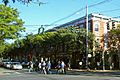
NY 308's western end at US 9 in downtown Rhinebeck
-
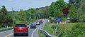
View east along NY 308 east of Rhinebeck
-
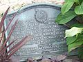
A plaque at the intersection of NY 308 and US 9, placed in 1922, marks the crossing of the Kings Highway and the former Sepasco Trail.
-
The Kingston–Rhinecliff Bridge


See also
 In Spanish: Ruta 308 del Estado de Nueva York para niños
