Niles, Michigan facts for kids
Quick facts for kids
Niles, Michigan
|
||
|---|---|---|
|
A view of downtown Niles
|
||
|
||
| Nickname(s):
The City of Four Flags
|
||

Location within Berrien County (left) and Cass County (right)
|
||
| Country | United States | |
| State | Michigan | |
| Counties | Berrien and Cass | |
| Settled | 1691 (Fort St. Joseph) | |
| Incorporated | 1835 (village) 1859 (city) |
|
| Government | ||
| • Type | Mayor–council | |
| Area | ||
| • Total | 5.95 sq mi (15.42 km2) | |
| • Land | 5.79 sq mi (15.01 km2) | |
| • Water | 0.16 sq mi (0.41 km2) | |
| Elevation | 686 ft (209 m) | |
| Population
(2020)
|
||
| • Total | 11,988 | |
| • Density | 2,069.04/sq mi (798.79/km2) | |
| Time zone | UTC-5 (Eastern (EST)) | |
| • Summer (DST) | UTC-4 (EDT) | |
| ZIP code(s) |
49120, 49121
|
|
| Area code(s) | 269 | |
| FIPS code | 26-57760 | |
| GNIS feature ID | 0633412 | |
Niles is a city in Berrien and Cass counties in the U.S. state of Michigan. It is located very close to the Indiana state line, near the city of South Bend. In 2020, about 11,988 people lived there. Niles is the larger of the two main cities in the Niles-Benton Harbor area, which has over 153,000 people.
Contents
History of Niles
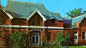
Niles is located along the St. Joseph River. This spot was once home to the French Fort St. Joseph. This fort was built in 1697 to protect a Jesuit mission that started in 1691.
After 1761, the British took control of the fort. But on May 25, 1763, Native Americans captured it during Pontiac's Rebellion. The British later got the fort back, but they didn't keep soldiers there. It became a trading post instead.
During the American Revolutionary War, a Spanish force briefly held the fort. Because the fort was controlled by four different nations—France, Britain, Spain, and the United States—Niles is known as the "City of Four Flags."
The town was named after Hezekiah Niles. He was the editor of a newspaper called Niles Register in Baltimore. The town of Niles as we know it today was settled in 1827. Between 1820 and 1865, Niles played an important role in the Underground Railroad. It helped enslaved people escape from as far south as New Orleans to freedom in Canada.
Geography and Climate
The city of Niles sits on the St. Joseph River. Most of the city is surrounded by Niles Township. The land here has rolling hills and steep river banks. You can find large boulders and smooth stones mixed with rich, fertile soil. Fossils, like crinoids, are also easy to find south of the city.
The city covers about 5.95 square miles (15.42 square kilometers). Most of this area is land, with a small part being water.
Niles Climate
Niles experiences a variety of weather throughout the year. Summers are generally warm, with average high temperatures in the 80s Fahrenheit (around 27-30 Celsius) in July and August. Winters are cold, with average high temperatures in the low 30s Fahrenheit (around 0 Celsius) in January and February.
The area gets a good amount of rain, especially in spring and summer. Snowfall is common in winter, with December and January seeing the most snow.
Population and People
| Historical population | |||
|---|---|---|---|
| Census | Pop. | %± | |
| 1870 | 4,630 | — | |
| 1880 | 4,197 | −9.4% | |
| 1890 | 4,197 | 0.0% | |
| 1900 | 4,287 | 2.1% | |
| 1910 | 5,156 | 20.3% | |
| 1920 | 7,311 | 41.8% | |
| 1930 | 11,326 | 54.9% | |
| 1940 | 11,328 | 0.0% | |
| 1950 | 13,145 | 16.0% | |
| 1960 | 13,842 | 5.3% | |
| 1970 | 12,988 | −6.2% | |
| 1980 | 13,115 | 1.0% | |
| 1990 | 12,458 | −5.0% | |
| 2000 | 12,204 | −2.0% | |
| 2010 | 11,600 | −4.9% | |
| 2020 | 11,988 | 3.3% | |
| U.S. Decennial Census | |||
Niles Population in 2010
In 2010, there were 11,600 people living in Niles. These people lived in 4,806 households, and 2,836 of these were families. The city had about 2,003 people per square mile.
About 32% of households had children under 18 living with them. Many households were married couples, while others were led by single parents or individuals living alone. The average household had about 2.37 people.
The average age of people in Niles was 36.1 years old. About 25.6% of residents were under 18, and 14.4% were 65 or older. The population was slightly more female (52.9%) than male (47.1%).
Things to See and Do
Niles has several interesting places to visit and fun activities.
The Chapin Mansion is a historic building downtown. It was built by Henry A. Chapin and used to be Niles City Hall.
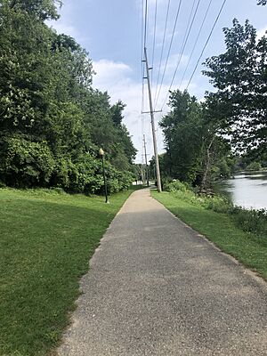
Riverfront Park stretches for about a mile and a half along the St. Joseph River. This park and the nearby downtown area are where many of the city's seasonal events take place. These events include the Niles Riverfest, the Bluegrass Festival, the Hunter Ice Festival, and the Apple Festival Parade. The park also has a memorial for the Armed Forces, a public stage, a free skateboard park, a playground, and sand volleyball courts.
Niles also has two other smaller parks. The Saint Joseph River Park is south of the French Paper Mill Factory Dam. Parts of this park are being explored by archaeologists. They have found many old items from the original Fort St. Joseph here. In the summer, they often have an "Open House" where you can visit the dig site, see the artifacts, and watch historical reenactments.
Island Park is a small park located on an island in the middle of the St. Joseph River. Sometimes, during very high flood waters, the park can become completely covered by water.
In 2003, the city worked to improve the look of Main Street. They removed old aluminum fronts from buildings and added brick sidewalks and flower beds. Jerry Tyler Airport is on the eastern edge of the city. It's where the city's annual Fourth of July celebration happens.
Just outside Niles, you can visit the Fernwood Botanical Garden and Nature Preserve to the northwest. Barron Lake is to the east. The University of Notre Dame is also nearby, about six miles south in South Bend, Indiana.
Niles is at the northern end of the Indiana-Michigan River Valley Trail. This is a system of trails for walking and biking that connects Niles with Mishawaka and South Bend, Indiana. The trail goes right through Riverfront Park.
Transportation and Services
Rail Travel
Niles is served by Amtrak trains. The two train lines that stop here are the Blue Water and the Wolverine. The Blue Water train travels between Chicago and Port Huron. The Wolverine train goes between Chicago and Pontiac. Freight trains also use these tracks, run by the Norfolk Southern Railway.
The Amtrak station in Niles is a historic building. It was built in 1892 and is listed on the National Register of Historic Places. You might recognize it from movies like Continental Divide, Midnight Run, and Only the Lonely.
Main Roads
Several important highways pass near or through Niles:
Local Transportation
Niles has its own public transportation system called the Niles Dial-A-Ride Transportation System (DART). It has been running since 1974. DART offers both on-demand rides and a fixed bus route. Route 2 runs through Niles on weekdays. Since 2011, it also stops in South Bend, Indiana, connecting to another bus system there.
Schools in Niles
The Niles Community Schools district has several schools:
- Elementary Schools: Northside (pre-K and K), Howard-Ellis (K-5), Ballard (K-5), and Eastside Connections School (K-8).
- Middle Schools: Ring Lardner (grades 6–8) and Eastside Connections School (grades 6–8).
- High Schools: Niles High School (grades 9-12) and Niles New Tech Entrepreneurial Academy (grade 9).
- Other schools include Cedar Lane (alternative education), Southside (special education), and Westside (adult education).
The Brandywine School District also serves parts of Niles. Its schools include Merritt Elementary (pre-K - 2), Brandywine Elementary (grades 3–6), and Brandywine Middle/High School (grades 7–12). They also have the Brandywine Innovation Academy for alternative education.
News and Media
The local newspaper for Niles is the Niles Daily Star. For television and radio, Niles is served by stations from South Bend, Indiana.
Famous People from Niles
Many notable people have connections to Niles:
- Joanna Beasley (born 1986) — a musician
- Fred Bonine (1863–1941) — an eye doctor
- Jake Cinninger (born 1975) — a musician from the band Umphrey's McGee
- Greydon Clark (born 1943) — a film director
- John Francis Dodge (1864–1920) — a pioneer in the automobile industry
- Horace Elgin Dodge (1868–1920) — another pioneer in the automobile industry
- Edward L. Hamilton (1857–1923) — a U.S. Representative
- Thomas Fitzgerald (1796–1855) — a U.S. Senator and judge
- Lottie Wilson Jackson (1854–1914) — a painter and advocate for women's rights
- Tommy James (born 1947) — a musician from the band Tommy James and the Shondells
- Ring Lardner (1885–1933) — a writer and sports columnist
- Lillian Luckey (1919–2021) — a player in the All-American Girls Professional Baseball League
- Michael Mabry (born 1955) — a graphic designer and illustrator
- Josh Priebe (born 2001) — an Offensive Lineman for the University of Michigan
- Dave Schmidt (born 1957) — a Major League Baseball pitcher
- Diane Seuss (born 1956) — a poet who won the Pulitzer Prize
- Aaron Montgomery Ward (1844–1913) — the founder of Montgomery Ward stores
- Michael D. West (born 1953) — founder of Geron and CEO of BioTime
See also
 In Spanish: Niles (Míchigan) para niños


