
Noflen facts for kids
Quick facts for kids
Noflen
|
||
|---|---|---|
|
||

Noflen
Location in Switzerland

Noflen
Location in Canton of Bern
|
||
| Country | Switzerland | |
| Canton | Bern | |
| District | Bern-Mittelland | |
| Area | ||
| • Total | 2.7 km2 (1.0 sq mi) | |
| Elevation | 630 m (2,070 ft) | |
| Population
(Dec 2012)
|
||
| • Total | 286 | |
| • Density | 105.9/km2 (274/sq mi) | |
| Postal code |
3116
|
|
| Surrounded by | Burgistein, Kienersrüti, Kirchdorf, Seftigen, Uetendorf | |

Noflen was once a small town, or municipality, located in the Bern-Mittelland area of Bern, a region in Switzerland. On January 1, 2018, Noflen joined with two other nearby towns, Gelterfingen and Mühledorf, to become part of the larger municipality of Kirchdorf. So, Noflen is no longer a separate town on its own.
Contents
History of Noflen
Noflen was first mentioned in old records in the year 1250. Back then, it was called Novelon. Not much is known about the very early days of the village.
Early Owners and Changes
By the 1200s and 1300s, several monasteries (places where monks or nuns live) and important families, called patrician families, owned land or had special rights in Noflen. Over time, these monasteries likely gained more power in the village.
However, in 1528, the city of Bern changed its official religion to Protestantism. This meant that lands owned by monasteries were taken over by the government. It's believed that Noflen became part of Bern around this time. The village has always been part of the local church area of Kirchdorf.
Modern Noflen
Today, people in the Noflen area mostly raise dairy cows and work on farms. In 2018, Noflen officially merged with Gelterfingen and Mühledorf to become part of Kirchdorf. This merger was planned for a while.
Geography of Noflen
Noflen covers an area of about 2.7 square kilometers (1 square mile). Most of this land, about 81.3%, is used for farming. Forests cover about 13.6% of the area. The remaining 5.9% is made up of buildings and roads.
Land Use
About half of the farming land (47.8%) is used for growing crops. Another 26.8% is used for pastures where animals graze. A smaller part, 6.6%, is used for orchards (fruit trees) or vineyards. All the forested land is covered with thick trees.
Village Layout
Noflen is a spread-out settlement. It has an upper and lower village located on a flat area above the Gürbetal (Gürbe valley). Part of the town is also on the valley floor itself. Since 1948, a small village called Stoffelsrüti joined Noflen. Before that, it was a separate piece of land belonging to another town, Jaberg.
Coat of Arms
The official design of Noflen's coat of arms is a silver shield. On it, there is a red rose with green leaves and seeds. On either side of the rose are two golden ox horns. At the bottom, there is a green hill.
Population of Noflen
As of 2012, Noflen had a population of 286 people. About 7% of these people were foreign nationals living in the town. Between 2010 and 2012, the population grew by 11.7%. Most of this growth (7.8%) was due to people moving into Noflen.
Languages Spoken
In 2000, most people in Noflen (99.2%) spoke German as their main language. A small number of people spoke Albanian.
Where People Were Born
In 2000, about 44% of the people living in Noflen were born there. Another 38.3% were born in the same region (canton) of Bern. About 12.9% were born elsewhere in Switzerland, and 2% were born outside of Switzerland.
Age Groups
In 2012, children and teenagers (ages 0-19) made up 25.2% of Noflen's population. Adults (ages 20-64) were the largest group at 60.5%. Seniors (over 64 years old) made up 14.3% of the population.
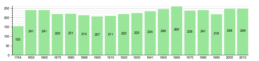
Population Over Time
The chart below shows how Noflen's population has changed over many years:
Economy and Work
In 2011, Noflen had a very low unemployment rate of 0.77%. This means almost everyone who wanted a job had one.
Jobs in Noflen
In 2011, 124 people worked in Noflen. These jobs were divided into three main types:
- Primary sector: 88 people worked in this sector, mostly in agriculture (farming).
- Secondary sector: 6 people worked in this sector, which includes manufacturing and construction.
- Tertiary sector: 30 people worked in this sector, which includes services like sales, technical jobs, and education.
Most people who lived in Noflen also worked there. In 2000, 55 workers (85.9%) both lived and worked in the municipality. For those who commuted, about 7.9% used public transportation, and 49.6% used a private car to get to work.
Religion in Noflen
Based on a survey from 2000, most people in Noflen (88.3%) belonged to the Swiss Reformed Church, which is a Protestant church. A smaller number (2.0%) were Roman Catholic. Other Christian churches were followed by 2.02% of the population. About 2.02% of people were Muslim. Around 2.42% said they didn't belong to any church, or were agnostic (not sure if God exists) or atheist (don't believe in God).
Education in Noflen
In Noflen, about 57.7% of the population had completed non-mandatory upper secondary education. This is like high school. Also, 19.2% had gone on to higher education, such as university or a specialized college.
School System
The school system in the Canton of Bern works like this:
- One year of non-required Kindergarten.
- Six years of Primary school.
- Three years of required lower Secondary school. In this stage, students are grouped by their abilities.
After lower Secondary school, students can choose to continue their education or start an apprenticeship (learning a trade on the job).
During the 2011-2012 school year, there were 20 students in 2 kindergarten classes in Noflen. In 2000, 26 students attended school within Noflen. Some students from Noflen also attended schools outside the municipality.
See also
 In Spanish: Noflen para niños
