Norwalk, Ohio facts for kids
Quick facts for kids
Norwalk, Ohio
|
|||
|---|---|---|---|

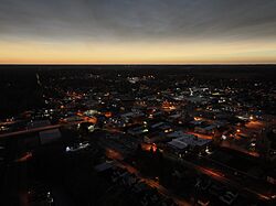
Downtown Norwalk during the 2024 Total Eclipse
|
|||
|
|||
| Nickname(s):
The Maple City
|
|||

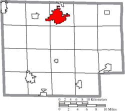
Location of Norwalk in Huron County
|
|||
| Country | United States | ||
| State | Ohio | ||
| County | Huron | ||
| Founded | 1817 | ||
| Area | |||
| • Total | 9.15 sq mi (23.69 km2) | ||
| • Land | 8.87 sq mi (22.96 km2) | ||
| • Water | 0.28 sq mi (0.73 km2) | ||
| Elevation | 715 ft (218 m) | ||
| Population
(2020)
|
|||
| • Total | 17,068 | ||
| • Density | 1,925.32/sq mi (743.36/km2) | ||
| Time zone | UTC-5 (Eastern (EST)) | ||
| • Summer (DST) | UTC-4 (EDT) | ||
| ZIP code |
44857
|
||
| Area code(s) | 419, 567 | ||
| FIPS code | 39-57302 | ||
| GNIS feature ID | 1086352 | ||
| Website | http://www.norwalkoh.com/ | ||
Norwalk is a city in Ohio, United States. It is the main city of Huron County. In 2020, about 17,068 people lived there. Norwalk is sometimes called "The Maple City." It is located about 10 miles (16 km) south of Lake Erie. The city is also part of a larger area that includes Cleveland and Akron.
Contents
History of Norwalk
The city of Norwalk, Ohio, has an interesting history that connects it to Norwalk, Connecticut. In 1779, the British burned down Norwalk, Connecticut. As a way to help the people who lost their homes, the U.S. government gave them land in Ohio in 1800. This area became known as the Firelands.
In 1815, a man named Platt Benedict from Connecticut visited this new land. He decided to buy 1,300 acres (5.3 km²) to start a town. In July 1817, Benedict and his family moved to Norwalk. They built the first permanent house there. Soon after, in 1818, Norwalk became the county seat, which means it became the main city for the county government.
Many early settlers in Norwalk came from New England. They brought their building styles and traditions with them. You can still see many of their old homes today. In 1881, Norwalk officially became a city.
Did you know that a common stomach bug, the norovirus, is named after Norwalk? It was first identified here in 1972 from a sample taken in the town. It was first called the "Norwalk Agent."
Geography and Climate
Norwalk is located in a special area called the Firelands. This name reminds us of how the area was settled. It was given to people from cities in Connecticut that were burned during the American Revolutionary War. Many towns in the Firelands are named after those Connecticut cities, like Danbury, Greenwich, and Norwalk itself.
The city covers about 9.15 square miles (23.69 km²). Most of this area is land, with a small part being water. Norwalk is surrounded by Norwalk Township. It is also about 12 miles (19 km) south of Lake Erie.
Weather in Norwalk
Norwalk experiences a climate with warm summers and cold winters. Here's a quick look at the weather:
| Climate data for Norwalk, Ohio, 1991–2020 normals, extremes 1894–present | |||||||||||||
|---|---|---|---|---|---|---|---|---|---|---|---|---|---|
| Month | Jan | Feb | Mar | Apr | May | Jun | Jul | Aug | Sep | Oct | Nov | Dec | Year |
| Record high °F (°C) | 72 (22) |
75 (24) |
85 (29) |
92 (33) |
98 (37) |
103 (39) |
108 (42) |
104 (40) |
102 (39) |
92 (33) |
82 (28) |
73 (23) |
108 (42) |
| Mean maximum °F (°C) | 58.4 (14.7) |
60.0 (15.6) |
69.6 (20.9) |
80.7 (27.1) |
86.7 (30.4) |
92.9 (33.8) |
93.2 (34.0) |
91.7 (33.2) |
89.6 (32.0) |
81.9 (27.7) |
69.5 (20.8) |
60.1 (15.6) |
94.6 (34.8) |
| Mean daily maximum °F (°C) | 33.4 (0.8) |
36.2 (2.3) |
45.5 (7.5) |
58.7 (14.8) |
70.2 (21.2) |
79.3 (26.3) |
83.0 (28.3) |
81.3 (27.4) |
75.5 (24.2) |
63.3 (17.4) |
49.7 (9.8) |
38.5 (3.6) |
59.6 (15.3) |
| Daily mean °F (°C) | 26.2 (−3.2) |
28.3 (−2.1) |
36.7 (2.6) |
48.4 (9.1) |
60.1 (15.6) |
69.5 (20.8) |
73.3 (22.9) |
71.4 (21.9) |
65.0 (18.3) |
53.3 (11.8) |
41.7 (5.4) |
31.8 (−0.1) |
50.5 (10.3) |
| Mean daily minimum °F (°C) | 19.0 (−7.2) |
20.4 (−6.4) |
27.9 (−2.3) |
38.1 (3.4) |
49.9 (9.9) |
59.8 (15.4) |
63.6 (17.6) |
61.6 (16.4) |
54.5 (12.5) |
43.3 (6.3) |
33.7 (0.9) |
25.1 (−3.8) |
41.4 (5.2) |
| Mean minimum °F (°C) | −1.2 (−18.4) |
3.2 (−16.0) |
11.2 (−11.6) |
24.9 (−3.9) |
35.4 (1.9) |
45.1 (7.3) |
52.4 (11.3) |
50.5 (10.3) |
41.2 (5.1) |
30.2 (−1.0) |
19.7 (−6.8) |
7.7 (−13.5) |
−4.0 (−20.0) |
| Record low °F (°C) | −23 (−31) |
−25 (−32) |
−15 (−26) |
7 (−14) |
19 (−7) |
29 (−2) |
34 (1) |
35 (2) |
23 (−5) |
12 (−11) |
−2 (−19) |
−17 (−27) |
−25 (−32) |
| Average precipitation inches (mm) | 2.68 (68) |
2.31 (59) |
2.90 (74) |
3.95 (100) |
3.91 (99) |
4.31 (109) |
4.19 (106) |
3.54 (90) |
3.55 (90) |
3.34 (85) |
2.83 (72) |
2.57 (65) |
40.08 (1,017) |
| Average snowfall inches (cm) | 9.7 (25) |
8.2 (21) |
5.1 (13) |
1.6 (4.1) |
0.0 (0.0) |
0.0 (0.0) |
0.0 (0.0) |
0.0 (0.0) |
0.0 (0.0) |
0.0 (0.0) |
1.5 (3.8) |
6.6 (17) |
32.7 (83.9) |
| Average precipitation days (≥ 0.01 in) | 13.7 | 11.6 | 11.9 | 13.2 | 13.0 | 11.5 | 10.2 | 9.9 | 9.4 | 10.8 | 10.4 | 11.9 | 137.5 |
| Average snowy days (≥ 0.1 in) | 7.8 | 6.6 | 3.6 | 0.9 | 0.0 | 0.0 | 0.0 | 0.0 | 0.0 | 0.0 | 1.3 | 4.9 | 25.1 |
| Source 1: NOAA | |||||||||||||
| Source 2: National Weather Service | |||||||||||||
People of Norwalk
| Historical population | |||
|---|---|---|---|
| Census | Pop. | %± | |
| 1820 | 179 | — | |
| 1830 | 310 | 73.2% | |
| 1840 | 1,113 | 259.0% | |
| 1850 | 1,437 | 29.1% | |
| 1860 | 2,839 | 97.6% | |
| 1870 | 4,498 | 58.4% | |
| 1880 | 5,704 | 26.8% | |
| 1890 | 7,195 | 26.1% | |
| 1900 | 7,074 | −1.7% | |
| 1910 | 7,858 | 11.1% | |
| 1920 | 7,379 | −6.1% | |
| 1930 | 7,776 | 5.4% | |
| 1940 | 8,211 | 5.6% | |
| 1950 | 9,775 | 19.0% | |
| 1960 | 12,900 | 32.0% | |
| 1970 | 13,386 | 3.8% | |
| 1980 | 14,348 | 7.2% | |
| 1990 | 14,731 | 2.7% | |
| 2000 | 16,238 | 10.2% | |
| 2010 | 17,012 | 4.8% | |
| 2020 | 17,068 | 0.3% | |
| Sources: | |||
In 2010, about 17,012 people lived in Norwalk. The city had 6,764 households. The population density was about 1,918 people per square mile (740 people per km²).
About 26% of the people living in Norwalk were under 18 years old. About 14.6% were 65 years or older. The average age in the city was 37 years. There were slightly more females (52.2%) than males (47.8%) living in Norwalk.
Education in Norwalk
Norwalk has several schools for students. Most of the city is served by the Norwalk City School District. Some parts of the city are also served by other school districts, including Edison Local, Monroeville Local, and Western Reserve Local School Districts.
There are also religious schools in Norwalk. These include Norwalk Catholic Schools (which includes Saint Paul High School) and Trinity Christian Academy.
Transportation Around Norwalk
Norwalk is easy to reach by road. The major highways I-80 and I-90, also known as the Ohio Turnpike, are about 3.5 miles (5.6 km) north of the city. You can get on them from U.S. Route 250. Other important U.S. highways that go through Norwalk are U.S. Route 20 and U.S. Route 250.
Several Ohio state routes also pass through Norwalk. These include State Route 13, State Route 18, and State Route 61. There's also State Route 601, which acts as a bypass around the eastern side of Norwalk.
For air travel, Norwalk has the Huron County Airport for smaller planes. A freight train line, the Wheeling and Lake Erie Railroad, also runs through the city.
Notable People from Norwalk
Many interesting people have come from Norwalk, Ohio:
- Fred Baker — He helped start the Scripps Institution of Oceanography.
- Alice Rufie Jordan Blake — She was the first woman to graduate from Yale Law School.
- Paul Brown — A famous American football coach who is in the Hall of Fame.
- Ray Gandolf — A well-known sportscaster.
- Lefty Grove — A Hall of Fame baseball pitcher.
- Ron Hackenberger — A car collector who has over 700 vehicles in Norwalk.
- Frank Avery Hutchins — A notable librarian.
- Ban Johnson — He was the first president of baseball's American League.
- George Kennan — A journalist and explorer.
- Vahdah Olcott-Bickford — A talented classical guitarist.
- Dennis A. Reed — A member of the Wisconsin State Assembly.
- Stephen M. Young — He served as a U.S. Senator and House member for Ohio.
See also
 In Spanish: Norwalk (Ohio) para niños


