Nuckolls County, Nebraska facts for kids
Quick facts for kids
Nuckolls County
|
|
|---|---|

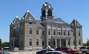
Nuckolls County Courthouse in Nelson
|
|

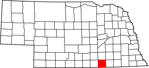
Location within the U.S. state of Nebraska
|
|
 Nebraska's location within the U.S. |
|
| Country | |
| State | |
| Founded | 1860 (founded) 1871 (organized) |
| Named for | Stephen Friel Nuckolls |
| Seat | Nelson |
| Largest city | Superior |
| Area | |
| • Total | 576 sq mi (1,490 km2) |
| • Land | 575 sq mi (1,490 km2) |
| • Water | 0.7 sq mi (2 km2) 0.1%% |
| Population | |
| • Estimate
(2021)
|
4,060 |
| • Density | 7.43/sq mi (2.87/km2) |
| Time zone | UTC−6 (Central) |
| • Summer (DST) | UTC−5 (CDT) |
| Congressional district | 3rd |
Nuckolls County is a county located in the state of Nebraska in the United States. As of 2020, about 4,095 people lived there. The main town, or county seat, is Nelson.
When Nebraska set up its license plate system in 1922, Nuckolls County was given the prefix 42. This was because it had the 42nd largest number of vehicles registered in the county at that time.
Contents
History
How Nuckolls County Started
Nuckolls County was first created in 1860. It officially became organized in 1871. The county was named after two brothers: Lafayette Nuckolls and Stephen Friel Nuckolls. Lafayette was a member of Nebraska's first government. Stephen was a pioneer, meaning he was one of the first settlers in the area. He was also a businessman and banker.
Stephen Friel Nuckolls was involved in a historical event in 1860. He had an enslaved person named Eliza Grayson, who had escaped two years earlier using the Underground Railroad. This was a secret network that helped enslaved people find freedom. Nuckolls tried to bring Eliza back from Chicago, where she was found. However, local police arrested Nuckolls and his helper. An abolitionist group, who were against slavery, helped Eliza escape to Canada.
Railroad History
In 1887, the Atchison, Topeka and Santa Fe Railway built a train line. It went from Neva, Kansas, to Superior, Nebraska. Over time, some parts of the tracks were removed.
Today, the BNSF Line from Superior, Nebraska, to Lost Springs, Kansas, is still active. It carries train traffic to and from Superior. This train line was first called the "Strong City and Superior line." Later, its name was shortened to the "Strong City line." In 1996, the Atchison, Topeka and Santa Fe Railway joined with another company to become the BNSF Railway. Even so, many local people still call it the "Santa Fe" railroad.
Geography
Nuckolls County is located on the southern border of Nebraska. Its southern edge touches the northern border of Kansas. The Republican River flows through the southwest part of the county.
Two creeks, Elk Creek and Oxbow Creek, flow through the northern part of the county. They empty into Crooked Creek, which then flows into Thayer County. The land in Nuckolls County has rolling hills covered in plants. It slopes gently towards the east. A lot of the land is used for farming, especially in the northeast.
Nuckolls County covers a total area of 576 square miles. Most of this, 575 square miles, is land. Only a small part, about 0.7 square miles, is water.
Major Highways
Neighboring Counties
- Clay County - north
- Fillmore County - northeast
- Thayer County - east
- Republic County, Kansas - southeast
- Jewell County, Kansas - southwest
- Webster County - west
Protected Natural Areas
- Smartweed Marsh State Wildlife Management Area
Population Information
| Historical population | |||
|---|---|---|---|
| Census | Pop. | %± | |
| 1860 | 22 | — | |
| 1870 | 8 | −63.6% | |
| 1880 | 4,235 | 52,837.5% | |
| 1890 | 11,417 | 169.6% | |
| 1900 | 12,414 | 8.7% | |
| 1910 | 13,019 | 4.9% | |
| 1920 | 13,236 | 1.7% | |
| 1930 | 12,629 | −4.6% | |
| 1940 | 12,781 | 1.2% | |
| 1950 | 10,973 | −14.1% | |
| 1960 | 8,217 | −25.1% | |
| 1970 | 7,404 | −9.9% | |
| 1980 | 6,726 | −9.2% | |
| 1990 | 7,586 | 12.8% | |
| 2000 | 5,057 | −33.3% | |
| 2010 | 4,500 | −11.0% | |
| 2020 | 4,095 | −9.0% | |
| 2021 (est.) | 4,060 | −9.8% | |
| US Decennial Census 1790-1960 1900-1990 1990-2000 2010-2013 |
|||
In 2020, the population of Nuckolls County was 4,095 people. The population density was about 7 people per square mile.
The median age in the county was 44 years old. About 23% of the population was under 18 years old.
Communities
Cities
Villages
Unincorporated Communities
These are smaller places that are not officially organized as cities or villages.
See also
 In Spanish: Condado de Nuckolls para niños
 | Charles R. Drew |
 | Benjamin Banneker |
 | Jane C. Wright |
 | Roger Arliner Young |

