
Obergoms facts for kids
Quick facts for kids
Obergoms
|
||
|---|---|---|
 |
||
|
||

Obergoms
Location in Switzerland

Obergoms
Location in Canton of Valais
|
||
| Country | Switzerland | |
| Canton | Valais | |
| District | Goms | |
| Area | ||
| • Total | 155.93 km2 (60.20 sq mi) | |
| Elevation | 1,377 m (4,518 ft) | |
| Population
(Dec 2020 )
|
||
| • Total | 654 | |
| • Density | 4.194/km2 (10.863/sq mi) | |
| Postal code |
3999
|
|
| Localities | Oberwald, Ulrichen, Obergesteln, Gletsch | |

Obergoms is a municipality located in the beautiful Valais canton of Switzerland. It's found in the upper part of the Goms valley. This municipality was created on January 1, 2009, when three smaller towns – Ulrichen, Obergesteln, and Oberwald – decided to join together.
Contents
Discover the History of Obergoms
The towns that make up Obergoms have a long history. Obergesteln was first mentioned way back in 1322. Oberwald appeared in records in 1386, and Ulrichen was first noted in 1235.
Battles in Ulrichen's Past
The area around Ulrichen was once the site of two important battles during the Middle Ages.
The First Battle of Ulrichen (1211)
In 1211, the First Battle of Ulrichen took place. Troops from Bern, led by Duke Berthold V, were defeated by the army of the Canton of Valais. This army was led by Landrich von Mont, the Bishop of Sion. Historians still debate some of the details about this battle.
The Second Battle of Ulrichen (1419)
Another battle, the Second Battle of Ulrichen, happened in 1419. This time, it was between the Old Swiss Confederacy (led by Bern) and Valais. Valais won this battle too. After this victory, talks began that helped end a conflict called the Raron affair.
Exploring Obergoms' Geography

Obergoms is located at the very top of the Rhone river valley. It stretches all the way up to the famous Rhone glacier, which is where the river begins! High mountains surround the municipality on almost all sides.
Obergoms is a key meeting point for several mountain passes: the Grimsel, Furka, Nufenen, and Gries. Most of these passes have paved roads, except for the Gries Pass, which is a track. The Furka–Oberalp railway line also runs through Obergoms. Today, trains use a tunnel called the Furka Base Tunnel to go through the mountains. However, the older railway route over the Furka Pass is now a special heritage railway where you can still ride historic trains.
Settlements in Obergoms
The lowest town in Obergoms is Ulrichen. It sits in the Rhone valley at the start of the Nufenen and Gries Passes. The municipality also includes the Agene valley, where the Griessee lake and Gries glacier are found. To the south, Obergoms reaches the border with Italy. To the east, it touches the border with the canton of Ticino at the top of the Nufenen Pass.
Further up the Rhone valley, you'll find Obergesteln. This village is located on a natural hill formed by the Rhone glacier, about 1,353 meters (4,439 feet) above sea level. Mountains like the Sidelhorn and Pizzo Gallina overlook Obergesteln.
Next comes Oberwald, which is about 1,370 meters (4,495 feet) high, on the right side of the Rhone river. Across the river is Unterwassern. Even higher up the valley is Gletsch, at 1,757 meters (5,764 feet), and Belvedere, at 2,271 meters (7,451 feet). From Gletsch, the Grimsel Pass goes north into the canton of Bern. Belvedere offers views of the Rhone glacier, and the Furka Pass climbs up to the border with the canton of Uri.
Land Use in Obergoms
Obergoms covers an area of about 155.8 square kilometers (60.2 square miles). A quarter of this land (26%) is used for farming. About 9.6% is covered by forests. Only a small part (1%) has buildings or roads, while a large portion (63.3%) is unproductive land, like mountains and glaciers.
Population and People of Obergoms

Obergoms has a population of about 705 people (as of December 2007). Around 11.3% of the people living here are foreign nationals. Over the last ten years (1999–2009), the population has slightly decreased.
Most of the people in Obergoms are Swiss. In 2008, about 52.3% of the population were men and 47.7% were women.
Age Groups in Obergoms
In 2000, children and teenagers (ages 0–19) made up about 20.6% of the population. Adults (ages 20–64) were the largest group at 61.2%, and seniors (over 64) made up 18.2%.
Languages Spoken in Obergoms Villages
Obergesteln's Languages

In Obergesteln, most people (93.8%) speak German as their main language. Some also speak Serbo-Croatian (4.1%) or Czech (1.0%). Only a few speak French.
Oberwald's Languages


In Oberwald, the majority (95.8%) speak German. A smaller number speak Serbo-Croatian (2.3%) or Italian (0.8%).
Ulrichen's Languages

In Ulrichen, almost everyone (96.4%) speaks German. A small number speak Italian (1.4%) or Portuguese (1.4%).
Historical Population Trends
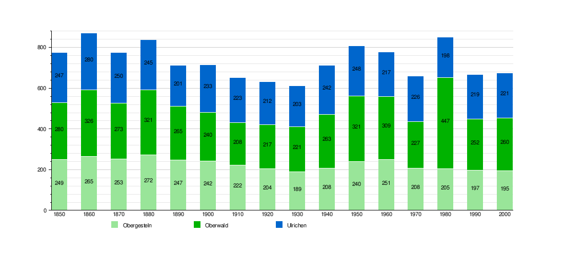
The chart below shows how the population of Obergesteln, Oberwald, and Ulrichen has changed over time:
Must-See Sights in Obergoms

If you visit Obergoms, you'll find some amazing sights! The entire villages of Obergesteln and Ulrichen are considered important historical sites. The Gletsch region is also special. A unique attraction is the Furkabahn Cog-Wheel Railway, a historic train line that offers incredible views. These places are all part of the Inventory of Swiss Heritage Sites, meaning they are protected for their historical and cultural value.
Obergoms' Economy and Jobs
In 2010, Obergoms had a low unemployment rate of 2.3%. The economy is divided into three main sectors:
- Primary sector: This includes jobs like farming and forestry. In 2008, 64 people worked in this sector.
- Secondary sector: This involves manufacturing and construction. There were 86 jobs in this sector.
- Tertiary sector: This covers services, like hotels, restaurants, and shops. This is the largest sector, with 239 people employed.
Many people in Obergoms use private cars to get to work (40.6%), while a smaller number (7.9%) use public transportation.
Getting Around Obergoms: Transport

Obergoms is well-connected by train. The Furka-Oberalp railway line of the Matterhorn Gotthard Bahn (MGB) serves the municipality. You can find train stations in Ulrichen, Obergesteln, and Oberwald. Trains run every hour, connecting Obergoms to places like Visp, Brig, Andermatt, and Göschenen.
The famous Glacier Express train also stops at Oberwald station several times a day, connecting Obergoms to popular destinations like Zermatt and St Moritz. From Oberwald, you can even take the Dampfbahn Furka-Bergstrecke, a special summer steam train that travels over the old MGB line across the Furka pass.
Road Travel in Obergoms
The main road that goes down the Rhone valley to Brig is open all year. However, the roads over the Furka, Grimsel, and Nufenen passes are only open during the summer months because of snow. To help with this, the MGB offers a special car shuttle train through the Furka Base Tunnel. This allows cars to travel between Oberwald and Realp without having to drive over the Furka pass.
During the summer, PostBus Switzerland also runs bus services from Oberwald across each of the passes. These buses can take you to Meiringen (over the Grimsel pass), Airolo (over the Nufenen pass), and Andermatt (over the Furka pass).
Education in Obergoms
The Obergoms school system had 57 students during the 2010–2011 school year. In the Canton of Valais, children can attend one year of non-mandatory Kindergarten. Obergoms had one kindergarten class with 15 students.
Students must attend six years of primary school. Obergoms had 4 primary school classes with 57 students. For secondary school, students from Obergoms travel to schools in nearby municipalities.
Religious Life in Obergoms

In Obergoms, most people are Roman Catholic. According to the 2000 census:
- In Obergesteln, 87.7% of the population was Roman Catholic.
- In Oberwald, 83.8% of the population was Roman Catholic.
- In Ulrichen, 95.0% of the population was Roman Catholic.
A smaller number of people belong to the Swiss Reformed Church or Orthodox churches. Some people also reported having no religious affiliation.
Obergoms' Climate
Obergoms experiences a varied climate due to its mountain location. Here's a look at the average weather conditions:
| Climate data for Obergoms (Ulrichen before 2009) 1991–2020 | |||||||||||||
|---|---|---|---|---|---|---|---|---|---|---|---|---|---|
| Month | Jan | Feb | Mar | Apr | May | Jun | Jul | Aug | Sep | Oct | Nov | Dec | Year |
| Mean daily maximum °C (°F) | −0.8 (30.6) |
1.7 (35.1) |
5.9 (42.6) |
9.9 (49.8) |
14.9 (58.8) |
19.4 (66.9) |
21.8 (71.2) |
21.3 (70.3) |
17.3 (63.1) |
12.6 (54.7) |
5.1 (41.2) |
−0.3 (31.5) |
10.7 (51.3) |
| Daily mean °C (°F) | −7.2 (19.0) |
−5.4 (22.3) |
−0.4 (31.3) |
3.9 (39.0) |
8.7 (47.7) |
12.6 (54.7) |
14.6 (58.3) |
14.0 (57.2) |
10.0 (50.0) |
5.5 (41.9) |
−0.7 (30.7) |
−5.6 (21.9) |
4.2 (39.6) |
| Mean daily minimum °C (°F) | −13.0 (8.6) |
−12.1 (10.2) |
−6.5 (20.3) |
−1.8 (28.8) |
2.4 (36.3) |
5.5 (41.9) |
7.5 (45.5) |
7.3 (45.1) |
3.8 (38.8) |
0.2 (32.4) |
−5.2 (22.6) |
−10.6 (12.9) |
−1.9 (28.6) |
| Average precipitation mm (inches) | 97 (3.8) |
81 (3.2) |
89 (3.5) |
88 (3.5) |
116 (4.6) |
95 (3.7) |
86 (3.4) |
100 (3.9) |
89 (3.5) |
107 (4.2) |
124 (4.9) |
110 (4.3) |
1,183 (46.6) |
| Average snowfall cm (inches) | 114.8 (45.2) |
132.6 (52.2) |
85.4 (33.6) |
26.3 (10.4) |
7.1 (2.8) |
0.2 (0.1) |
0.0 (0.0) |
0.0 (0.0) |
0.1 (0.0) |
13.5 (5.3) |
81.5 (32.1) |
116.6 (45.9) |
578.1 (227.6) |
| Average precipitation days (≥ 1.0 mm) | 9.6 | 9.0 | 9.0 | 8.9 | 11.3 | 10.9 | 11.0 | 11.3 | 9.0 | 9.2 | 10.6 | 10.2 | 120.0 |
| Average snowy days (≥ 1.0 cm) | 9.5 | 10.1 | 8.3 | 4.4 | 0.9 | 0.1 | 0.0 | 0.0 | 0.1 | 1.4 | 8.9 | 10.8 | 54.5 |
| Average relative humidity (%) | 84 | 79 | 74 | 69 | 69 | 70 | 70 | 73 | 76 | 79 | 84 | 85 | 76 |
| Mean monthly sunshine hours | 71 | 104 | 153 | 153 | 171 | 199 | 216 | 192 | 161 | 126 | 67 | 54 | 1,665 |
| Percent possible sunshine | 49 | 51 | 52 | 49 | 46 | 52 | 57 | 56 | 55 | 49 | 41 | 47 | 51 |
| Source: MeteoSwiss (snow 1981–2010) | |||||||||||||
See also
 In Spanish: Obergoms para niños
