
Ohio water resource region facts for kids
The Ohio water resource region is like a giant natural area that helps us organize and understand where water flows across a big part of the United States. Think of it as one of 21 main sections that the United States Geological Survey uses to divide the country. These sections help scientists study how water moves through rivers and streams.
This Ohio region is special because it includes almost all the land where water eventually flows into the Ohio River. It covers a huge area, about 162,916 square miles (421,930 km²)! This region is divided into 14 smaller parts, which helps experts manage water resources even better. You can find parts of this region in many states, including Illinois, Indiana, Kentucky, Maryland, New York, North Carolina, Ohio, Pennsylvania, Tennessee, Virginia, and West Virginia.

Contents
What is a Water Resource Region?
A water resource region is a large area of land where all the rain and snowmelt eventually drain into the same major river or group of rivers. It's like a giant funnel for water. The United States is divided into these regions to help manage water, understand floods, and protect our natural environment. Each region has a special code, and the Ohio region's code is 05.
The Ohio River Basin: A Huge Waterway
The Ohio water resource region is mainly focused on the Ohio River Basin. A "basin" is all the land where water drains into a particular river. The Ohio River is a very important river in the United States. It flows into the Mississippi River, which then flows into the Gulf of Mexico. This region helps us understand how water flows from many different smaller rivers and streams into the mighty Ohio River.
Why are Subregions Important?
To make it easier to study and manage such a huge area, the Ohio region is broken down into 14 smaller "subregions." Each subregion is usually the basin of a major river that flows into the Ohio River. For example, the Allegheny River and the Monongahela River each have their own subregion. This detailed breakdown helps scientists and water managers focus on specific areas.
Here are some of the main subregions within the Ohio water resource region:
- Allegheny Subregion: This area includes the Allegheny River Basin, located in Pennsylvania and New York. It's about 11,600 square miles (30,000 km²) in size.
- Monongahela Subregion: This subregion covers the Monongahela River Basin in Maryland, Pennsylvania, and West Virginia, measuring around 7,310 square miles (18,900 km²).
- Upper Ohio Subregion: This part of the Ohio River Basin is located below where the Allegheny and Monongahela rivers meet. It's found in Ohio, Pennsylvania, and West Virginia, covering about 13,200 square miles (34,200 km²).
- Muskingum Subregion: This subregion is entirely within Ohio and includes the Muskingum River Basin, which is about 7,980 square miles (20,700 km²).
- Kanawha Subregion: This area includes the Kanawha River Basin, located in North Carolina, Virginia, and West Virginia, and is about 12,200 square miles (31,600 km²).
- Scioto Subregion: Found in Ohio, this subregion covers the Scioto River Basin, which is about 6,440 square miles (16,700 km²).
- Big Sandy–Guyandotte Subregion: This subregion includes the Big Sandy River and Guyandotte River Basins in Kentucky, Virginia, and West Virginia, covering about 5,900 square miles (15,000 km²).
- Great Miami Subregion: This area includes the Great Miami River Basin in Indiana and Ohio, measuring around 5,330 square miles (13,800 km²).
- Middle Ohio Subregion: This part of the Ohio River Basin is located between the Kanawha and Kentucky River Basins. It's found in Indiana, Kentucky, Ohio, and West Virginia, covering about 8,850 square miles (22,900 km²).
- Kentucky–Licking Subregion: This subregion is entirely within Kentucky and includes the Licking River and Kentucky River Basins, which are about 10,500 square miles (27,200 km²).
- Green Subregion: This area includes the Green River Basin in Kentucky and Tennessee, measuring around 9,140 square miles (23,700 km²).
- Wabash Subregion: This subregion covers the Wabash River Basin in Illinois, Indiana, and Ohio, and is the largest at about 32,600 square miles (84,400 km²).
- Cumberland Subregion: This area includes the Cumberland River Basin in Kentucky and Tennessee, covering about 17,700 square miles (45,800 km²).
- Lower Ohio Subregion: This is the final part of the Ohio River Basin before it meets the Mississippi River. It's found in Illinois, Indiana, and Kentucky, covering about 12,500 square miles (32,400 km²).
Images for kids
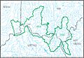
-
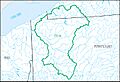
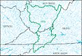
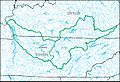
Allegheny Subregion
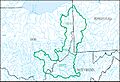
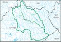
-
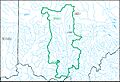
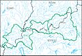
Monongahela Subregion
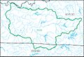
-
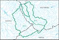
Upper Ohio Subregion
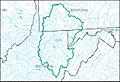
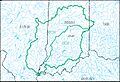
-
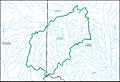
Muskingum Subregion
-
Kanawha Subregion
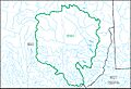
-
Scioto Subregion
-
Big Sandy–Guyandotte Subregion
-
Great Miami Subregion
-
Middle Ohio Subregion
-
Kentucky–Licking Subregion
-
Green Subregion
-
Wabash Subregion
-
Cumberland Subregion
-
Lower Ohio Subregion


