
Peachtree Creek facts for kids

Peachtree Creek is a big stream in Atlanta, Georgia. It flows about 7.5 miles (12.1 km) west. The creek then joins the Chattahoochee River near Vinings.
Peachtree Creek has played a key role in the history of the Atlanta area.
Contents
History of Peachtree Creek
Early History and Fort Peachtree
Long ago, Fort Peachtree was built close to the creek and the Chattahoochee River. This fort helped protect settlers from the Cherokee people. The Cherokee lived in the area northwest of the river.
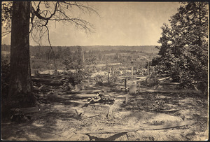
The Civil War Battle
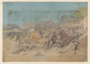
During the American Civil War, a major fight happened here. It was called the Battle of Peachtree Creek. This battle was an important part of the Atlanta Campaign.
A place called Pace's Ferry was built across the river near the creek. Today, Paces Ferry Road still follows the creek's path. Another street, Peachtree Battle Avenue, also runs nearby. People often call this area "Peachtree Battle."
Peachtree Creek's Branches
Peachtree Creek has two main branches, called tributaries. These are the North Fork Peachtree Creek and the South Fork Peachtree Creek.
North Fork Peachtree Creek
The North Fork starts near Gwinnett County. It flows southwest for about 13.5 miles (21.7 km). This branch runs almost perfectly next to Interstate 85 through DeKalb County. It meets the South Fork where the highway crosses Georgia 400.
South Fork Peachtree Creek
The South Fork is about 15.4 miles (24.8 km) long. It begins in Tucker. It flows south, then west, passing through Clarkston. This branch also flows through parts of Emory University's campus.
Water Flow and Flooding
Monitoring the Creek
Since 1912, scientists have watched Peachtree Creek closely. They use a special tool called a stream gauge. This gauge is located where the creek crosses Northside Drive. It helps them measure how much water is flowing.
When it rains 1 inch (2.5 cm), about 1.5 billion gallons (5.7 billion liters) of water flow into the creek's area. This area is called a watershed. Scientists also check the water quality here. They send this information to weather satellites in real time.
Understanding Floods
Flood stage means the water depth is 17.0 feet (5.2 m). Because many buildings are in the area, the creek often floods during heavy storms.
In September 2004, after Hurricane Frances and Hurricane Ivan, Peachtree Creek had a huge flood. The water reached 22.63 feet (6.90 m) deep. It was flowing at 14,200 cubic feet (402 cubic meters) per second. The creek became about ten times wider than normal. This was its highest official flood record.
The worst flood ever happened in 1919. The water reached 25.80 feet (7.86 m) deep. Another big flood happened in 1912.

Recent Floods
The 2009 Atlanta floods caused new records for many streams. Peachtree Creek at Northside Drive almost set a new record. It reached 23.89 feet (7.28 m) on September 21, 2009. The North Fork also reached a record height of 18.07 feet (5.51 m) during this flood.
Peachtree Creek Greenway
In 2017, plans were shared for the Peachtree Creek Greenway. This will be a path along Peachtree Creek. Construction started in 2018 in Brookhaven.
The greenway will give people places to walk and bike. It will connect the cities of Atlanta, Brookhaven, Chamblee, and Doraville. This project aims to help people get around and enjoy nature. It also helps the area grow in a good way.
