Pequop Mountains facts for kids
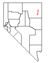
The Pequop Mountains are a group of mountains found in eastern Elko County, in the northeastern part of Nevada, in the western United States. These mountains stretch for about 51 miles (82 km) from north to south. The highest point in the range is an unnamed peak that stands 9,249 feet (2,819 meters) tall.
Contents
Exploring the Pequop Mountains
The Pequop Mountains are actually made up of two different sections. These sections are separated by a lower area of hills called Flower Pass. To the west of the mountains, you'll find Independence Valley and the East Humboldt Range. To the east, there's Goshute Valley and the Toano Range. The southern part of the Pequop Mountains connects with Spruce Mountain. This area is also home to the South Pequop Wilderness Study Area, which helps protect nature.
A Challenge for Travelers
These mountains have always been a tough obstacle for people traveling between the flat lands of the Great Salt Lake Desert and the Humboldt River Valley. Imagine trying to get across them before modern roads!
How Railways Crossed the Mountains
When the First Transcontinental Railroad was built, it went around the northern end of the Pequop Mountains. This path led it towards Promontory Summit in Utah. Later, another railway line called the Western Pacific Railroad found a different way. It went through a tunnel in the mountains at Flower Pass. This pass was also part of an old travel route known as the Hastings Cutoff.
Today, both of these railway lines are operated by the Union Pacific Railroad. The first one is now part of the Lakeside Subdivision of the Overland Route. The second one is the Shafter Subdivision of the Central Corridor.
Interstate 80 and Pequop Summit
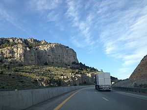
Modern travelers can cross the northern part of the Pequop Mountains using Interstate 80. This major highway reaches its highest point in the range at Pequop Summit, which is 6,967 feet (2,124 meters) high. This summit is the highest point on Interstate 80 between Parley's Summit in the Wasatch Mountains of Utah and Donner Summit in the Sierra Nevada Range of California.
 | Janet Taylor Pickett |
 | Synthia Saint James |
 | Howardena Pindell |
 | Faith Ringgold |


