Plessur District facts for kids
Quick facts for kids
Plessur District
Bezirk Plessur
|
|
|---|---|
|
District
|
|
 |
|
| Country | |
| Canton | |
| Capital | Chur |
| Area | |
| • Total | 266.75 km2 (102.99 sq mi) |
| Population
(December 2015)
|
|
| • Total | 40,707 |
| • Density | 152.604/km2 (395.241/sq mi) |
| Time zone | UTC+1 (CET) |
| • Summer (DST) | UTC+2 (CEST) |
| Municipalities | 5 |
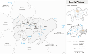
The Plessur District (also known as Bezirk Plessur in German) was a special area in the canton of Graubünden, Switzerland. It was named after the Plessur River, which flows through it. The whole valley along this river is called Schanfigg.
This district covered about 266.73 square kilometers (about 103 square miles). In 2015, around 40,707 people lived there. The Plessur District was changed into the Plessur Region on January 1, 2017. This was part of a big plan to reorganize the canton.
Contents
Parts of Plessur District
The Plessur District was made up of three smaller areas called Kreise (sub-districts). These sub-districts then had a total of twelve municipalities (towns or villages).
Chur Sub-district
The Chur sub-district had only one main municipality:
Churwalden Sub-district
The Churwalden sub-district included these municipalities:
In 2010, the areas of Malix and Parpan became part of Churwalden.
Schanfigg Sub-district
The Schanfigg sub-district included these municipalities:
In 2013, several smaller municipalities joined Arosa. These included Calfreisen, Castiel, Langwies, Lüen, Molinis, Peist, and St. Peter-Pagig.
Changes Over Time
Over the years, some municipalities in the Plessur District joined together to form larger ones. This helps with managing the areas better.
Municipality Mergers
- On January 1, 2010, the towns of Malix and Parpan became part of the municipality of Churwalden.
- On January 1, 2013, several smaller municipalities merged into the municipality of Arosa. These were Calfreisen, Castiel, Langwies, Lüen, Molinis, Peist, and St. Peter-Pagig.
Languages Spoken
People in the Plessur District speak different languages. Here's a look at the main languages spoken there, based on a census from 2000:
| Languages of Plessur District, GR | ||||||
| Languages | Census 2000 | |||||
| Number | Percent | |||||
| German | 32,655 | 81.9% | ||||
| Romansh | 1,873 | 4.7% | ||||
| Italian | 1,831 | 4.6% | ||||
| TOTAL | 39,892 | 100% | ||||
See also
 In Spanish: Distrito de Plessur para niños
- Araschgen
 | Valerie Thomas |
 | Frederick McKinley Jones |
 | George Edward Alcorn Jr. |
 | Thomas Mensah |

