Pontotoc County, Mississippi facts for kids
Quick facts for kids
Pontotoc County
|
||
|---|---|---|

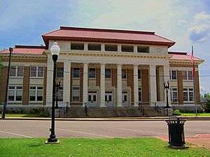
Pontotoc County Courthouse in Pontotoc
|
||
|
||

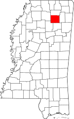
Location within the U.S. state of Mississippi
|
||
 Mississippi's location within the U.S. |
||
| Country | ||
| State | ||
| Founded | 1836 | |
| Named for | Chickasaw word for the region meaning either "cattail prairie" "land of hanging grapes" | |
| Seat | Pontotoc | |
| Largest city | Pontotoc | |
| Area | ||
| • Total | 501 sq mi (1,300 km2) | |
| • Land | 498 sq mi (1,290 km2) | |
| • Water | 3.3 sq mi (9 km2) 0.7% | |
| Population
(2020)
|
||
| • Total | 31,184 | |
| • Density | 62.24/sq mi (24.032/km2) | |
| Time zone | UTC−6 (Central) | |
| • Summer (DST) | UTC−5 (CDT) | |
| Congressional district | 1st | |
Pontotoc County is a special area called a county in the state of Mississippi, USA. It's like a district or region within the state. In 2020, about 31,184 people lived there. The main town, or county seat, where the county government is located, is Pontotoc.
Pontotoc County was officially created on February 9, 1836. This happened after the Chickasaw people, who lived there before, agreed to give their land to the United States. The name "Pontotoc" comes from the Chickasaw language and means "land of hanging grapes."
An important historical path, the original Natchez Trace, and the modern-day Natchez Trace Parkway both go through the southeast part of Pontotoc County. This county is also part of the larger Tupelo area, which is a group of towns connected economically.
Contents
Geography of Pontotoc County
Pontotoc County covers a total area of about 501 square miles. Most of this area, around 498 square miles, is land. The rest, about 3.3 square miles, is water.
Main Roads and Highways
Several important roads pass through Pontotoc County, making it easy to travel to other places. These include:
 Interstate 22
 U.S. Route 78
 U.S. Route 278
 Mississippi Highway 6
 Mississippi Highway 9
 Mississippi Highway 15
 Mississippi Highway 41
- Natchez Trace Parkway
Neighboring Counties
Pontotoc County shares its borders with several other counties:
- Union County (to the north)
- Lee County (to the east)
- Chickasaw County (to the south)
- Calhoun County (to the southwest)
- Lafayette County (to the west)
Protected Natural Areas
Parts of two important natural areas are found in Pontotoc County:
- Natchez Trace Parkway
- Tombigbee National Forest
Population Over Time
The number of people living in Pontotoc County has changed a lot over the years. Here's how the population has grown or shrunk during different times:
| Historical population | |||
|---|---|---|---|
| Census | Pop. | %± | |
| 1840 | 4,491 | — | |
| 1850 | 17,112 | 281.0% | |
| 1860 | 22,113 | 29.2% | |
| 1870 | 12,525 | −43.4% | |
| 1880 | 13,858 | 10.6% | |
| 1890 | 14,940 | 7.8% | |
| 1900 | 18,274 | 22.3% | |
| 1910 | 19,688 | 7.7% | |
| 1920 | 19,962 | 1.4% | |
| 1930 | 22,034 | 10.4% | |
| 1940 | 22,904 | 3.9% | |
| 1950 | 19,994 | −12.7% | |
| 1960 | 17,232 | −13.8% | |
| 1970 | 17,363 | 0.8% | |
| 1980 | 20,918 | 20.5% | |
| 1990 | 22,237 | 6.3% | |
| 2000 | 26,726 | 20.2% | |
| 2010 | 29,957 | 12.1% | |
| 2020 | 31,184 | 4.1% | |
| 2023 (est.) | 31,535 | 5.3% | |
| U.S. Decennial Census 1790-1960 1900-1990 1990-2000 2010-2013 |
|||
Who Lives in Pontotoc County?
In 2020, there were 31,184 people living in Pontotoc County. These people lived in 10,783 households, and 7,943 of these were families. The county is home to people from many different backgrounds. Most residents are White, followed by African American, with smaller numbers of Native American, Asian, and people of mixed heritage. About 6.57% of the population is Hispanic or Latino.
Towns and Communities
Pontotoc County has one main city and several smaller towns and communities.
City
- Pontotoc (This is the county seat, meaning it's where the county government is located.)
Towns
Special Designated Place
- Randolph (This is a "census-designated place," which means it's an area identified for statistics but isn't an officially incorporated town.)
Smaller Communities
These are places where people live but are not officially incorporated as cities or towns:
Education in Pontotoc County
Children in Pontotoc County attend schools managed by two different school districts:
- Pontotoc County Schools
- Pontotoc City Schools
See also
 In Spanish: Condado de Pontotoc (Misisipi) para niños
 | Dorothy Vaughan |
 | Charles Henry Turner |
 | Hildrus Poindexter |
 | Henry Cecil McBay |


