Pownal, Maine facts for kids
Quick facts for kids
Pownal, Maine
|
|
|---|---|

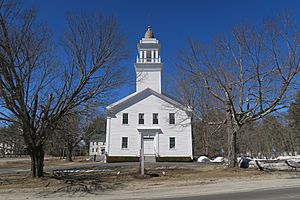
First Parish Congregational Church
|
|

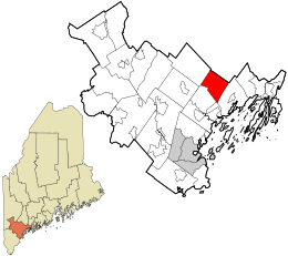
Location in Cumberland County and the state of Maine.
|
|
| Country | United States |
| State | Maine |
| County | Cumberland |
| Incorporated | 1808 |
| Villages | North Pownal Pownal Center West Pownal |
| Area | |
| • Total | 22.88 sq mi (59.26 km2) |
| • Land | 22.86 sq mi (59.21 km2) |
| • Water | 0.02 sq mi (0.05 km2) |
| Elevation | 226 ft (69 m) |
| Population
(2020)
|
|
| • Total | 1,566 |
| • Density | 68/sq mi (26.4/km2) |
| Time zone | UTC-5 (Eastern (EST)) |
| • Summer (DST) | UTC-4 (EDT) |
| ZIP code |
04069
|
| Area code(s) | 207 |
| FIPS code | 23-60685 |
| GNIS feature ID | 0582684 |
Pownal is a small town in Cumberland County, Maine, United States. In 2020, about 1,566 people lived there. Pownal is known for being home to Bradbury Mountain State Park, a popular spot for outdoor activities. It is also part of the larger Portland area.
Contents
History of Pownal
Pownal was first settled in 1680. It was originally the northwest part of a town called Freeport. On March 3, 1808, Pownal officially became its own town. This was decided by the Massachusetts General Court, which was like the state government at the time.
The town was named after Thomas Pownall, who used to be a governor. He had passed away three years before the town was named. In 1813 and 1816, Pownal traded some land with the nearby town of North Yarmouth.
Early Life and Industries
The land in Pownal was good for farming, so agriculture became the main job for people living there. By 1859, about 1,074 people lived in Pownal. Besides farming, the town also had other businesses. There was a gristmill, which ground grain into flour. There was also a factory that made carriages.
Pownal in Books
The famous author Stephen King chose Pownal as the setting for some of his stories. In his 1979 novel The Dead Zone, the main character, Johnny Smith, is a schoolteacher from Pownal. Pownal is also the hometown of Ray Garraty in King's 1979 novel The Long Walk. Stephen King himself grew up in a nearby town called Durham.
Geography of Pownal
Pownal covers an area of about 22.88 square miles (59.26 square kilometers). Most of this area is land, with only a tiny bit being water. The town's water flows into the eastern parts of the Royal River.
A main road, Maine State Route 9, helps people travel through the town.
Population and People
| Historical population | |||
|---|---|---|---|
| Census | Pop. | %± | |
| 1790 | 2,043 | — | |
| 1800 | 1,678 | −17.9% | |
| 1810 | 872 | −48.0% | |
| 1820 | 1,058 | 21.3% | |
| 1830 | 1,308 | 23.6% | |
| 1840 | 1,210 | −7.5% | |
| 1850 | 1,074 | −11.2% | |
| 1860 | 1,053 | −2.0% | |
| 1870 | 981 | −6.8% | |
| 1880 | 874 | −10.9% | |
| 1890 | 712 | −18.5% | |
| 1900 | 592 | −16.9% | |
| 1910 | 625 | 5.6% | |
| 1920 | 514 | −17.8% | |
| 1930 | 462 | −10.1% | |
| 1940 | 575 | 24.5% | |
| 1950 | 752 | 30.8% | |
| 1960 | 778 | 3.5% | |
| 1970 | 800 | 2.8% | |
| 1980 | 1,189 | 48.6% | |
| 1990 | 1,262 | 6.1% | |
| 2000 | 1,491 | 18.1% | |
| 2010 | 1,474 | −1.1% | |
| 2020 | 1,566 | 6.2% | |
| U.S. Decennial Census | |||
The population of Pownal has changed over many years. The chart above shows how many people lived in Pownal during different census years. A census is a count of the population that happens every ten years.
Pownal in 2010
In 2010, there were 1,474 people living in Pownal. These people lived in 590 different homes. Most of the people living in Pownal were White. About 29.7% of homes had children under 18 living there. The average age of people in Pownal was about 44.6 years old.
Places to Visit
- Bradbury Mountain State Park is a popular place to visit in Pownal. It offers trails for hiking and a chance to enjoy nature.
Notable Person from Pownal
- Frank Knight was an arborist, which means he was an expert in caring for trees. He was from Pownal.
See also
 In Spanish: Pownal (Maine) para niños
 | Anna J. Cooper |
 | Mary McLeod Bethune |
 | Lillie Mae Bradford |

