Lake Macquarie (New South Wales) facts for kids
Quick facts for kids Lake Macquarie |
|
|---|---|
| Newcastle, Central Coast, New South Wales | |
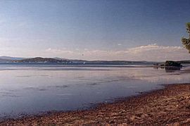
View from Swansea showing Pulbah Island
|
|
| Location | Hunter, Central Coast () |
| Coordinates | 33°05′S 151°35′E / 33.083°S 151.583°E |
| Type | An open and trained youthful wave dominated barrier estuary |
| Native name | Awaba (Awabakal) |
| Primary inflows | Cockle Creek, Dora Creek |
| Primary outflows | Tasman Sea |
| Catchment area | 604.4 km2 (233.4 sq mi) |
| Basin countries | Australia |
| Max. length | 24 km (14.9 mi) |
| Max. width | 7.9 km (4.9 mi) |
| Surface area | 110 km2 (42.5 sq mi) |
| Average depth | 8 m (26 ft) |
| Max. depth | 15 m (49 ft) |
| Shore length1 | 174 km (108.1 mi) |
| Surface elevation | 0 m (0 ft) AHD |
| Frozen | never |
| Islands | Pulbah Island plus several small islands |
| Settlements | City of Lake Macquarie, Central Coast Council |
| 1 Shore length is not a well-defined measure. | |
| Pulbah Island Nature Reserve New South Wales |
|
|---|---|
|
IUCN Category Ia (Strict Nature Reserve)
|
|

Photo showing the northern side of Pulbah Island
|
|
| Nearest town or city | Lake Macquarie |
| Established | July 1970 |
| Area | 68 ha (168 acres) |
| Visitation | Restricted |
| Website | Pulbah Island Nature Reserve |
| See also | Protected areas of New South Wales |
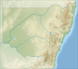
Lake Macquarie (called Awaba by the local Aboriginal people) is Australia's largest coastal lagoon. It is located in New South Wales, Australia, near the cities of Lake Macquarie and Central Coast. The lake covers an area of 110 square kilometres (42.5 sq mi). It connects to the Tasman Sea through a short channel. Most people living in the City of Lake Macquarie live close to the lake's shores.
Lake Macquarie is twice the size of Sydney Harbour. It is the largest coastal saltwater lagoon in the Southern Hemisphere. It is a bit smaller than Port Stephens, which is about 43 kilometres (27 mi) to the northeast.
Contents
History of Lake Macquarie
Aboriginal people of the Awabakal nation lived around Lake Macquarie for thousands of years. They called the lagoon Awaba, which means "a plain surface". There are many important Aboriginal sites in this area. These include Butterfly Cave, Glenrock State Reserve, and Pulbah Island Nature Reserve.
Europeans first saw Lake Macquarie in July 1800. Captain William Reid was looking for coal near the Hunter River. He thought the entrance to Lake Macquarie was the Hunter River. He collected coal from a spot now called ‘Reid’s Mistake’. This is how he accidentally found the lake and the coalfields. When he returned to Sydney, Reid learned he had not gone far enough north to reach the Hunter River. The lake was called "Reid's Mistake" until 1826. It was then renamed to honour Governor Lachlan Macquarie.
Geography and Environment
Lake Macquarie has an uneven shape. The land between the lake and the ocean is only a few kilometres wide in most places. There are several small, sandy islands in the lake. Some are grouped near the entrance. Pulbah Island, located south of Swansea, is a large island with rocky cliffs and great views.
Lake Macquarie connects to the sea through two channels: Swansea Channel and Lake Entrance. Swansea Channel is about 380 metres (1,247 ft) wide and 2 kilometres (1.2 mi) long. It joins Lake Entrance, which is about 900 m (2,953 ft) wide and 2.2 km (1.4 mi) long at the Swansea bridges. These bridges can lift up. This allows yachts and other large boats to enter and leave the lake.
You cannot see the entire lake and its 174 km (108 mi) shoreline from one spot on the coast. However, you can get a good view from lookouts in the nearby Watagan Mountains.
Important Bird Area
The remaining eucalypt forests on the southern edges of the lake are very important for birds. BirdLife International has named this area an Important Bird Area (IBA). It covers 121 square kilometres. This area is home to many endangered swift parrots and regent honeyeaters. They visit when the swamp mahoganies and other favourite trees are flowering. Masked owls and ospreys also build their nests here regularly.
Pulbah Island Nature Reserve
The Pulbah Island Nature Reserve is a protected area of 68-hectare (168-acre) located in the southern part of Lake Macquarie. It is about 1.6 kilometres (1 mi) long. This makes it the largest island in the lake.
The NSW National Parks & Wildlife Service manages Pulbah Island. There are no permanent buildings on the island, and no one lives there. The name Pulbah is an Australian indigenous Awabakal word meaning "island".
Weeds are a problem on the island. Local groups have worked to remove and control weeds like Bitou bush, Lantana, and Wandering Jew. The island also has native trees such as spotted gum.
Kangaroos and koalas were brought to the island in the early 1900s. However, they were later removed due to illegal hunting. Goannas are commonly seen on the island.
From Pulbah Island, you can clearly see the Wangi Wangi peninsula. You can also see the Eraring, Munmorah, and Vales Point power stations.
The island has cliffs on its west, south, and southeast sides. The rest of the island has sandy beaches. However, at high tide, there is not much beach left because of thick plants. The east side of the island has a small bay. This bay is often visited by leisure boats. Camping is not allowed on the island. But you can go bushwalking and have picnics.
Pulbah Island is also a sacred site for the Awabakal Aboriginal people. It was officially declared an Aboriginal place in 1982.
Environmental Management
In 1983, a study looked into why the water quality in Lake Macquarie was poor. The study found that too much sediment (dirt and sand) and nutrients were entering the lake. Sediment levels were very high, estimated at 75,000 tonnes (73,815 long tons) each year. Nutrient levels had also increased a lot because of city development. Before European settlement, much less sediment entered the lake. Two creeks, Cockle and Dora Creeks, were adding a lot of sediment.
In 1998, the NSW Premier, Bob Carr, created a special group to help the lake. This group recommended a new way to manage the lake and its surrounding land. The Office of the Lake Macquarie and Catchment Coordinator was set up. This was a joint effort by the City of Lake Macquarie, the former Wyong Shire (now Central Coast Council), and the NSW Government. They all provided funding. A committee was also formed to guide the work.
The plan to improve Lake Macquarie focused on working together. It aimed to solve water problems by dealing with stormwater runoff (rainwater that flows into the lake) from the land. The plan used natural methods and restored natural processes where possible. After six years, the project continued into its third phase in 2006.
Scientists use different ways to check the water quality. The lake generally has low nutrient levels, clear water, and good oxygen levels. Actions that reduce sediment and nutrients from stormwater runoff have helped improve the water. These actions include building wetlands, installing special stormwater devices, restoring natural bushland, and making the local community more aware.
Recreational fishing is getting better. Fish numbers are increasing because commercial fishing was stopped. The water quality has also improved a lot due to environmental programs by the government and local councils. Some areas of the lake bed have more silt (fine dirt) due to unsealed roads and city growth. However, this is much less than in nearby Lake Munmorah. Swimming in Lake Macquarie is generally good. The average depth of the lake is about 8 m (26 ft). The deepest part is about 15 m (49 ft) east of Pulbah Island.
Recreation and Activities
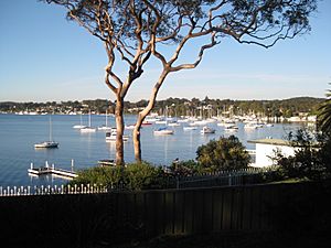
Many fun activities happen on Lake Macquarie. These include fishing, boating, kayaking, and water skiing. Kayaking is becoming more and more popular. Sailing and yacht racing are also very popular. The lake has many yacht clubs, including:
- Belmont 16 ft Sailing Club
- Lake Macquarie Yacht Club, Belmont
- Mannering Park Amateur Sailing Club
- Marmong Pt Sailing Club
- Royal Motor Yacht Club of NSW, Toronto
- Speers Point Amateur Sailing Club
- South Lake Macquarie Amateur Sailing Club
- Teralba Amateur Sailing Club
- Toronto Amateur Sailing Club Toronto
- Wangi RSL Amateur Sailing Club


