Punta Rassa, Florida facts for kids
Quick facts for kids
Punta Rassa, Florida
|
|
|---|---|

Location in Lee County and the state of Florida
|
|
| Country | United States |
| State | |
| County | Lee |
| Area | |
| • Total | 4.47 sq mi (11.57 km2) |
| • Land | 2.39 sq mi (6.19 km2) |
| • Water | 2.08 sq mi (5.39 km2) |
| Elevation | 3 ft (1 m) |
| Population
(2020)
|
|
| • Total | 1,620 |
| • Density | 678.39/sq mi (261.89/km2) |
| Time zone | UTC−5 (Eastern (EST)) |
| • Summer (DST) | UTC−4 (EDT) |
| ZIP code |
33908
|
| Area code(s) | 239 |
| FIPS code | 12-59250 |
| GNIS feature ID | 0289383 |
Punta Rassa is a small community in Lee County, Florida, USA. It's not a city, but a "census-designated place" (CDP). This means it's an area identified by the government for statistics. In 2020, about 1,620 people lived here. This number was a bit lower than in 2010. Punta Rassa is part of the larger Cape Coral-Fort Myers, Florida Metropolitan Statistical Area.
Contents
Geography of Punta Rassa
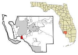
Punta Rassa is in southwest Lee County. It sits at the end of a piece of land. To the north is the Caloosahatchee River. To the west is San Carlos Bay. The Gulf of Mexico is to the south.
This community is at the start of the Sanibel Causeway. This causeway is a bridge that crosses San Carlos Bay to Sanibel Island. McGregor Boulevard (County Road 867) runs along the southern edge of Punta Rassa. This road goes northeast about 15 miles (24 km) to Fort Myers. Fort Myers is the main city in Lee County. East of Punta Rassa is the community of Iona.
The total area of Punta Rassa is about 4.5 square miles (11.6 square kilometers). Most of this area, about 2.4 square miles (6.2 square kilometers), is land. The rest, about 2.1 square miles (5.4 square kilometers), is water.
History of Punta Rassa
The name Punta Rasca was given by Spanish explorers in the mid-1500s. It means "smooth or flat point." Over time, the name changed to "Punta Rassa." The Spanish used this area to unload cattle.
By the mid-1700s, fishermen from Cuba set up fishing stations here. These were called ranchos. They dried and salted fish to send to Havana. Native Americans, like the Calusa and later the Seminole, worked at these ranchos. In 1833, a doctor named Benjamin Strobel visited a rancho at Punta Rassa. He saw about ten wooden houses there.
Punta Rassa During the Seminole Wars
Punta Rassa was important during the Seminole Wars. These wars happened between 1835 and 1842, and again from 1855 to 1858. In 1837, Fort Dulany was built here. It was an army supply base with a hospital. The fort was used to hold Seminole prisoners before they were moved west.
A hurricane destroyed Fort Dulany in 1841. Army operations then moved to Fort Harvie, further up the Caloosahatchee River. Fort Harvie was later abandoned. In 1850, a new Fort Myers was built on the ruins of Fort Harvie. Fort Dulany was used again during the Third Seminole War in 1856, then closed in 1858.
Punta Rassa in the Civil War
During the American Civil War, Union troops came to Punta Rassa in 1864. They marched to Fort Myers and took control of it. Union troops and supporters started moving cattle from Florida to Punta Rassa. These cattle were then sent to supply Union ships and Key West. This reduced the cattle available to the Confederate forces.
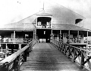
Because of the increased shipping, the Union Army built a barracks and a wharf at Punta Rassa. The barracks was a large building, 50 by 100 feet (15 by 30 meters). It was built on tall pilings, 14 feet (4.3 meters) high, to protect it from storm surges. After the Civil War ended, the U.S. military left the area.
The Telegraph Comes to Punta Rassa
In 1866, a new company called the International Ocean Telegraph Company (IOTC) got permission to run an underwater telegraph cable between Florida and Cuba. In 1867, the IOTC built a telegraph line from Lake City to Punta Rassa. This line connected to the national telegraph network.
The underwater cable was laid from Havana to Key West, and then to Punta Rassa. The line opened on September 11, 1867. The IOTC set up its office in one room of the old barracks at Fort Dulany. The station agent lived in another room.
Punta Rassa as a Cattle Port
Punta Rassa became a busy town for shipping cattle in the late 1800s. The first cattle drive to Punta Rassa was in 1833. Florida cattlemen began sending cattle to Cuba after the Third Seminole War. At first, cattle were shipped from Tampa or other ports. By 1872, most cattle shipped from Florida to Cuba went through Punta Rassa. About 18,000 cattle were shipped from here that year.
Most cattle drives in Florida were not very long. Three or four hundred cattle would be moved by a few cowboys for about 100 miles (160 km). Some drives were larger, with up to 1,500 cattle and ten cowboys. The longest drives were about 300 miles (480 km), from Fernandina (near the Georgia border) to Punta Rassa. Finding enough water for the cattle was often a problem.
The International Ocean Telegraph Company controlled the wharf. For many years, they charged 15 cents for each cow loaded onto a ship. Later, other cattlemen built their own pens and wharves. Jake Summerlin, a famous Florida cattle baron, built a hotel in Punta Rassa in 1874. When the hotel was full, cowboys would camp under the building.
Cattle were loaded onto ships at the port and sent to Cuba. Punta Rassa was a home base for Jake Summerlin, known as the "King of the Cracker Cowboys." By age 40, he was one of the richest cattle owners in Florida. The town of Punta Rassa had many wooden buildings, including a hotel and bars. Merchants and cattle sellers often visited these places.
Sport Fishing and Tourism in Punta Rassa
In the 1880s, Punta Rassa became known for great sport fishing. Wealthy people came here to catch the prized tarpon fish. However, visitors soon moved to Boca Grande. This town was about 70 miles (110 km) north by land, but only about 25 miles (40 km) by water. A railroad was built to Boca Grande, making it easier to reach.
A railroad line was also planned for Punta Rassa in the early 1920s. The Seaboard Air Line Railroad wanted to create a deepwater port here. The 8-mile (13 km) line branched off their main track. It ran through what is now Lakes Park. The line ended just east of Punta Rassa. However, the railroad stopped all operations in the Fort Myers area in 1952. The abandoned line is still called Seaboard's Punta Rassa Branch. Today, an FPL power line follows part of the old railroad path.
The area of Punta Rassa was featured in the 1984 historical novel A Land Remembered by Patrick D. Smith.
Population and Demographics
| Historical population | |||
|---|---|---|---|
| Census | Pop. | %± | |
| 1990 | 1,493 | — | |
| 2000 | 1,731 | 15.9% | |
| 2010 | 1,750 | 1.1% | |
| 2020 | 1,620 | −7.4% | |
| U.S. Decennial Census | |||
In 2000, there were 1,731 people living in Punta Rassa. There were 1,015 households and 481 families. The population density was about 735 people per square mile (284 per square kilometer). Most people (99.25%) were White. A small number were African American, Native American, or Asian. About 0.23% of the population was Hispanic or Latino.
Most households (52.0%) were made up of individuals living alone. Many of these (48.7%) were people aged 65 or older. Only 1.5% of households had children under 18. The average household had 1.53 people. The average family had 2.09 people.
The population of Punta Rassa is mostly older adults. In 2000, 82.5% of residents were 65 years or older. The median age was 80 years. For every 100 females, there were about 64 males.
The median income for a household in Punta Rassa was $44,583. For a family, it was $66,912. The average income per person was $39,048. Very few people (1.9%) lived below the poverty line.
See also
 In Spanish: Punta Rassa para niños


