Pánuco River facts for kids
Quick facts for kids Pánuco River |
|
|---|---|

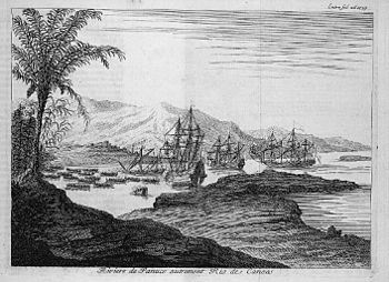
Pánuco River, a.k.a. Río de Canoas. Copper-plate engraving from Dutch artist Jan Karel Donatus van Beecq.
|
|

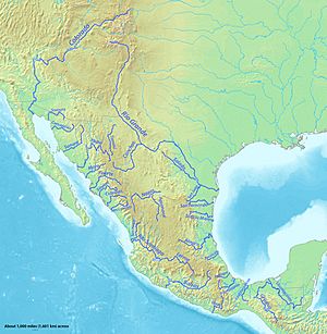
Major rivers of Mexico, with Pánuco near the center
|
|
| Native name | Río Pánuco |
| Other name(s) | Río de Canoas |
| Country | |
| States | Mexico Hidalgo Querétaro San Luis Potosí Tamaulipas Veracruz |
| Physical characteristics | |
| Main source | Confluence of Moctezuma and Tampaón Rivers 3,800 metres (12,500 ft) 21°58′05″N 98°33′48″W / 21.96806°N 98.56333°W |
| River mouth | Gulf of Mexico at Ciudad Madero 0 m (0 ft) 22°16′00″N 97°47′00″W / 22.26667°N 97.78333°W |
| Length | 510 kilometres (320 mi) |
| Basin features | |
| Basin size | 84,956 square kilometres (32,802 sq mi) |
The Pánuco River (Spanish: Río Pánuco) is a major river in Mexico. It is also known as the Río de Canoas. This river gets its water from several smaller rivers, like the Moctezuma River. It then flows into the Gulf of Mexico.
The Pánuco River is about 510 kilometres (320 mi) long. It flows through or along the borders of many Mexican states. These states include Mexico, Hidalgo, Querétaro, San Luis Potosí, Tamaulipas, and Veracruz. Interestingly, one of the main sources of the Moctezuma River is the Tula River. This means the Pánuco River eventually helps drain the Valley of Mexico, which is where Mexico City is located.
Contents
About the Pánuco River

Near where it starts, the Pánuco River helps carry away water from Mexico City. As it flows, it forms part of the border between the states of Hidalgo and Querétaro. It then moves towards San Luis Potosí. The river only gets the name Río Pánuco when it reaches the state of Veracruz.
The Pánuco River finally empties into the Gulf of Mexico. This happens near the cities of Tampico and Ciudad Madero. Here, it also forms the border between the states of Tamaulipas and Veracruz. The Tampico Bridge is a large bridge that crosses the river close to where it meets the Gulf.
River Size and Importance
The Pánuco River is over 500 km long. However, only the last 15 km of the river are deep enough for large ships to travel on. It is a very important river for Mexico.
According to the Atlas of Mexico, the Pánuco is the fourth-largest river in Mexico by the amount of water it carries. It also has the sixth-largest river basin in Mexico by area. A river basin is all the land where water drains into that river and its tributaries. The Pánuco River and its smaller rivers collect water from parts of many states. These include Tamaulipas, San Luis Potosí, Guanajuato, Querétaro, Hidalgo, Mexico, Puebla, and Veracruz.
In 1519, a Spanish explorer named Alonso Álvarez de Pineda explored the coast of the Gulf of Mexico. He set up a small settlement on the Pánuco River. He called it Las Palmas. But this settlement was later abandoned after he was killed in a battle with the local people.
Amazing Fish Life in the Pánuco River
The Pánuco River basin is home to many different kinds of fish. There are nearly 100 species of fish living here. A few of these species were brought in from other places.
Many fish found here are endemic. This means they live only in this river basin and nowhere else in the world. Some examples of these unique fish include:
- Six types of Nosferatu cichlid fish.
- Five types of Tampichthys minnows.
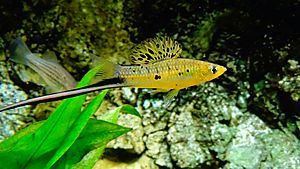
- Nine types of "northern swordtails" from the genus Xiphophorus. The Montezuma swordtail is one of these.
- Three types of Gambusia fish.
- Two types of Ictalurus catfish.
- The bluetail goodeid (Ataeniobius toweri).
- The dusky splitfin (Goodea gracilis).
- The relict splitfin (Xenoophorus captivus).
- The pygmy shiner (Notropis tropicus).
- The checkered pupfish (Cualac tessellatus).
- The broadspotted molly (Poecilia latipunctata).
- The Tamasopo cichlid (Herichthys tamasopoensis).
- The Calabazas shiner (Notropis calabazas).
- The fleshylip buffalo (Ictiobus labiosus).
Scientists also know about a few other fish species in this river basin that have not yet been officially named. Sadly, some of these unique fish are seriously threatened and need protection.
See also
 In Spanish: Río Pánuco para niños
 | Misty Copeland |
 | Raven Wilkinson |
 | Debra Austin |
 | Aesha Ash |


