Richmond, Vermont facts for kids
Quick facts for kids
Richmond, Vermont
|
|
|---|---|

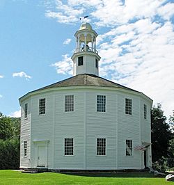
Round Church, completed in 1813
|
|

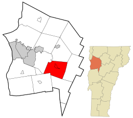
Location in Chittenden County and the state of Vermont
|
|
| Country | United States |
| State | Vermont |
| County | Chittenden |
| Incorporated | 1794 |
| Communities | Richmond Fays Corner Jonesville |
| Area | |
| • Total | 32.7 sq mi (84.8 km2) |
| • Land | 32.2 sq mi (83.5 km2) |
| • Water | 0.5 sq mi (1.4 km2) |
| Elevation | 289 ft (88 m) |
| Population
(2020)
|
|
| • Total | 4,167 |
| • Density | 129/sq mi (49.9/km2) |
| Time zone | UTC-5 (Eastern (EST)) |
| • Summer (DST) | UTC-4 (EDT) |
| ZIP code |
05477
|
| Area code(s) | 802 |
| FIPS code | 50-59275 |
| GNIS feature ID | 1462186 |
Richmond is a small town located in Chittenden County, Vermont, in the United States. In 2020, about 4,167 people lived here. The main part of town, also called Richmond, is a smaller community within the town. It had about 853 residents in 2020.
Contents
History of Richmond
Early Settlement and Growth
The first people to try and settle in Richmond were Amos Brownson and John Chamberlain in 1775. They left later that year but came back in 1784 after the Revolutionary War ended.
Richmond officially became a town on October 27, 1794. It was set up and organized in 1795. The Winooski River and Huntington River flow through the area. These rivers were important because they provided power for water mills.
Many different businesses started up in Richmond. They made things like wagons, harnesses, and items from tin and brass. People also created furniture and woodenware. By 1859, the town's population had grown to 1,453 people.
The Famous Round Church
Richmond is well-known for its unique Round Church. This building has 16 sides, which is very unusual! It was built between 1812 and 1813.
The church was first used as a place for town meetings and as a Protestant church. Today, it is a popular spot for visitors and is open to the public.
Geography and Location

Richmond covers about 84.8 square kilometers (32.7 square miles). Most of this area is land, with about 1.4 square kilometers (0.5 square miles) being water. The Winooski River cuts through the middle of Richmond. The Huntington River, a smaller river, also flows through the southeast part of town.
Richmond is located in the western part of the Green Mountains. These are a range of mountains in Vermont.
Transportation in Richmond
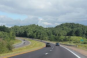
The town is easy to reach by major roads. Interstate 89 goes through Richmond, and you can get off at Exit 11. U.S. Route 2 also crosses the town. The New England Central Railroad runs through Richmond as well.
If you are driving south on Interstate 89, you can see a beautiful view of Camel's Hump. This is a famous mountain in the Green Mountains.
Education for Students
Students in Richmond attend several local schools. These include Richmond Elementary School and Camel's Hump Middle School. For high school, students go to Mount Mansfield Union High School. This high school is in the nearby town of Jericho.
The sports teams at Mount Mansfield Union High are called the Cougars. They often play against teams from other local schools, like CVU.
Mount Mansfield Modified Union School District
In 2014, several communities, including Richmond, voted to create a new school district. This district is called the Mount Mansfield Modified Union School District (MMMUSD). It includes schools from Bolton, Jericho, Richmond, and Underhill.
This new district helps manage schools for students from pre-kindergarten all the way through 12th grade. It includes elementary schools, middle schools, and Mount Mansfield Union High School.
Population Information
| Historical population | |||
|---|---|---|---|
| Census | Pop. | %± | |
| 1800 | 718 | — | |
| 1810 | 935 | 30.2% | |
| 1820 | 1,014 | 8.4% | |
| 1830 | 1,109 | 9.4% | |
| 1840 | 1,054 | −5.0% | |
| 1850 | 1,453 | 37.9% | |
| 1860 | 1,400 | −3.6% | |
| 1870 | 1,309 | −6.5% | |
| 1880 | 1,264 | −3.4% | |
| 1890 | 1,115 | −11.8% | |
| 1900 | 1,057 | −5.2% | |
| 1910 | 1,419 | 34.2% | |
| 1920 | 1,447 | 2.0% | |
| 1930 | 1,315 | −9.1% | |
| 1940 | 1,225 | −6.8% | |
| 1950 | 1,278 | 4.3% | |
| 1960 | 1,303 | 2.0% | |
| 1970 | 2,249 | 72.6% | |
| 1980 | 3,159 | 40.5% | |
| 1990 | 3,729 | 18.0% | |
| 2000 | 4,090 | 9.7% | |
| 2010 | 4,081 | −0.2% | |
| 2020 | 4,167 | 2.1% | |
| U.S. Decennial Census | |||
In 2000, Richmond had 4,090 people living in 1,504 households. About 1,100 of these were families. The population density was about 49.6 people per square kilometer (128.4 per square mile).
Many households (41.2%) had children under 18 living with them. Most households (62.2%) were married couples. The average household had 2.71 people, and families averaged 3.13 people.
The median age in Richmond was 37 years old. About 29.3% of the population was under 18. About 6.8% of the people were 65 years or older.
Notable People from Richmond
Richmond has been home to several interesting people:
- Trey Anastasio: The lead singer and guitarist for the rock band Phish.
- Barbara Ann Cochran: An Olympic alpine skier. She is part of the famous Skiing Cochrans family.
- George F. Edmunds: A former US Senator.
- Joel Furr: An internet personality who created the term "spam" for unwanted emails.
- Louis Greenough: A pioneer and inventor.
- Ted King: A retired professional cyclist. He now focuses on gravel and adventure cycling. He also helped start UnTapped, a maple syrup product company in Richmond.
- John Phillips: A physician and politician from Wisconsin.
- George Dallas Sherman: The first leader of the Burlington Concert Band.
See also
 In Spanish: Richmond (Vermont) para niños
 | Lonnie Johnson |
 | Granville Woods |
 | Lewis Howard Latimer |
 | James West |


