Rio Chama facts for kids
Quick facts for kids Rio Chama |
|
|---|---|
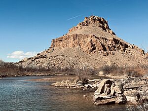
The Rio Chama near Abiquiú, New Mexico
|
|
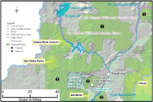
Map of the Rio Chama within New Mexico, showing reservoirs and "wild and scenic" stretch
|
|
| Country | United States |
| State | New Mexico, Colorado |
| Counties | Rio Arriba County, New Mexico, Archuleta County, Colorado, Conejos County, Colorado |
| Physical characteristics | |
| Main source | Confluence of West Fork and East Fork San Juan Mountains, Rio Grande National Forest, Colorado 9,440 ft (2,880 m) 37°05′36″N 106°33′06″W / 37.09333°N 106.55167°W |
| River mouth | Rio Grande San Juan Indian Reservation, New Mexico 5,620 ft (1,710 m) 36°2′32″N 106°5′16″W / 36.04222°N 106.08778°W |
| Length | 130 mi (210 km) |
| Basin features | |
| Basin size | 3,144 sq mi (8,140 km2) |
| Type: | Wild, Scenic |
| Designated: | November 7, 1988 |
The Rio Chama is a major river that flows through the states of Colorado and New Mexico in the United States. It is a very important branch of the larger Rio Grande river. The Rio Chama is about 130 miles (210 km) long in total.
The river's name, "Chama," comes from the Tewa people. It is a shorter way of saying tsąmą' ǫŋwįkeyi, which means "wrestling pueblo-ruin." This name tells us a bit about the history of the area.
Contents
The Rio Chama's Journey: Where it Flows
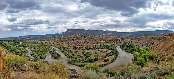
The Rio Chama starts high up in the mountains of south-central Colorado. Its journey begins in the San Juan Mountains within the Rio Grande National Forest. The main river forms when two smaller streams, the West Fork and East Fork, join together.
The West Fork flows from the Continental Divide. This is a high ridge where water flows to either the Atlantic or Pacific Ocean. The East Fork starts in Conejos County, Colorado. After these two forks meet, the Rio Chama flows south.
Through New Mexico's Landscapes
Soon, the river enters Rio Arriba County, New Mexico. It flows past the town of Chama. Along its way, other streams join it. For example, Willow Creek flows into the Rio Chama after passing through Heron Lake. This lake is a reservoir created by Heron Dam.
A few miles further, the Rio Chama flows into El Vado Lake. This is another large reservoir formed by El Vado Dam. These dams help manage the river's water.
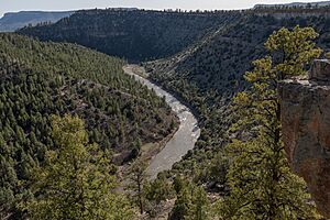
After El Vado Dam, the river continues its path south. It enters the beautiful Chama Canyon and the Santa Fe National Forest. Here, it flows through the Chama River Canyon Wilderness. The Rio Cebolla and Rio Gallina are two more rivers that join the Chama in this area.
Next, the river reaches Abiquiu Lake, which is a reservoir made by Abiquiu Dam. The Rio Puerco also adds its water to the Chama in Abiquiu Lake.
The Final Stretch to the Rio Grande
Below Abiquiu Dam, the Rio Chama turns east. It flows near the edge of Carson National Forest. It passes by the town of Abiquiú. After this, it turns to flow southeast.
Near the villages of Chili and La Chuachia, two more important rivers join the Chama. The Rio del Oso comes from the west. Then, very close by, the Rio Ojo Caliente joins from the northeast.
Finally, after several more miles, the Rio Chama meets the mighty Rio Grande. This meeting point is near Ohkay Owingeh. This is about 5 miles (8.0 km) north of Española. It is also about 30 miles (48 km) north of Santa Fe.
A Look Back: The History of the Rio Chama
People have lived near and used the Rio Chama for a very long time. Scientists believe humans were in this area almost 10,000 years ago. Back then, large animals like camels and mammoths roamed the southwestern United States.
In 1988, a special part of the river was recognized. A 24.6 miles (39.6 km) section, known as Chama Canyon, was named a National Wild and Scenic River. This means the U.S. Congress decided to protect this part of the river. It helps keep the river and its surroundings natural and beautiful for everyone.
Fun on the Rio Chama: Recreation and Activities
The Rio Chama is a popular place for outdoor activities. Many people enjoy boating and fishing on its waters.
Whitewater Boating Adventures
The upper parts of the Rio Chama can be very exciting for whitewater boating. There are large rocks, big drops, and hidden logs. This makes it challenging for experienced kayakers. The first 6 miles (9.7 km) to 7.5 miles (12.1 km) above El Vado Lake is a very difficult section. It is only for expert whitewater kayakers.
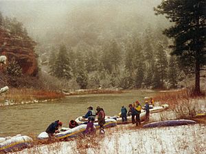
Other parts of the river are less challenging. Canoeists and kayakers with good skills can enjoy Class I to III rapids. These sections flow through deep canyons. Below El Vado Lake, the river is mostly Class II to III. This means it's suitable for most people with intermediate boating skills.
A very popular section for paddlers is the 31.1 miles (50.1 km) stretch. This runs from El Vado Ranch through Chama Canyon and Chavez Canyon. It ends at the Big Eddy access point above Abiquiu Reservoir. Remember, some parts of the river below Abiquiu Dam are on private land. Always ask for permission before boating or fishing there.
Fishing for Trout
The Rio Chama and its smaller streams are great for fly fishing. You can catch different types of trout here.
- Upper River Fishing: About 10 miles (16 km) of the Rio Chama, above Wolf Creek, is private land. You need permission from the landowner to fish here. This area has wild brown trout. Wolf Creek has cutthroat trout, and both streams have rainbow trout.
- Rio Chamita Access: The Rio Chamita flows into the Rio Chama. You can reach it from a dirt road about one and a half miles north of the town of Chama.
- North and South of Chama: There is good trout fly fishing north of Chama on NM 17. There are special rules for fishing in this area. South of Chama, the Rio Brazos joins the Rio Chama. Most of this section is on private land. However, there is a 4 miles (6.4 km) stretch south of Chama that is open to the public.
- Below Rio Brazos: After the Rio Brazos joins, the Rio Chama offers excellent fly fishing. This area is wide with large pools and big rocks. It's a great spot for rainbow and wild brown trout.
Chama Canyon: A Natural Wonder
The Chama Canyon is a truly amazing place. Its walls rise about 1,500 feet (460 m) above the river. These tall walls are made of different types of rock. You can see steep sandstone and shale cliffs. There are also rock slides, ledges, and tall pinnacles.
The rocks in Chama Canyon are very old. Some of them formed about 110 million years ago! You can find shale, basalt, sandstone, and granite here.
Plants and Animals of the Chama Valley
The Chama Valley is home to many different kinds of plants. You can find tall ponderosa pine trees and douglas-fir trees. There are also smaller trees like pinyon and juniper. Other plants include mountain mahogany, gambel oak, and serviceberry.
Near the river, you'll see cottonwood trees, box elder, and willows. Many other shrubs grow here too.
The valley is full of wildlife! You might spot large animals like cougars, black bears, elk, and mule deer. Smaller animals include badgers, bobcats, coyotes, beavers, and raccoons.
Many birds live here, such as ducks, dippers, and Canada geese. You might also see large birds of prey like golden eagles, bald eagles, falcons, hawks, and owls.
The river itself is home to many fish. You can find brown and rainbow trout, flathead chub, and channel catfish. Various types of rattlesnakes also live in the nearby mountains and canyons.


