River Effra facts for kids
Quick facts for kids Effra |
|
|---|---|

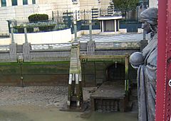
Diverted overflow outlet of the Effra into the Thames, by Vauxhall Bridge, beneath Alfred Drury's sculpture of Science
|
|
| Other name(s) | Brixton Creek, New River, The Wash |
| Country | England |
| Counties | Greater London |
| Physical characteristics | |
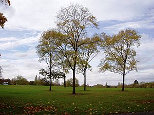
| Main source | Upper Norwood Recreation Ground, Upper Norwood, London Borough of Croydon 51°25′02″N 0°05′29″W / 51.4171°N 0.0914°W |
| River mouth | River Thames historically Walworth Marsh; outlet now at Vauxhall 51°29′14″N 0°07′33″W / 51.4872°N 0.1257°W |
| Basin features | |
| Tributaries |
|
The River Effra is a stream that used to flow openly through south London, England. Today, most of it runs underground in pipes, like a hidden river. It was once a small branch of the famous River Thames. During the Victorian era, its waters were made part of a large underground system that carried away waste and rainwater from areas like Peckham and Brixton.
Contents
What's in a Name? The Effra's Story
The name "Effra" has a bit of a mystery around it. People didn't start calling the stream "Effra" until the late 1700s. Before that, maps from the 1700s called it "the Shore." It was also known as "Brixton Creek" or "the Wash."
Some people had interesting ideas about where the name came from. One thought it was from a Latin word, another from an old Celtic word. But these ideas are probably not correct.
A more likely idea is that "Effra" comes from the name "Heathrow." This was a large farm that used to be in the area. By the 1790s, this farm was known as Effra Farm. It seems the stream near Brixton was first called Effra, taking its name from the farm. Later, the name spread to the rest of the stream's path. This idea is supported by local historians today.
A Look Back: The Effra's History
Before the 1800s
The area where the Effra collected its water was about 20 square kilometers (8 square miles) of what is now inner south London. The Effra got its water from springs that popped out of the ground. These springs were located along a ridge called the Great North Wood. There were also springs at a lower level in Dulwich. All these smaller streams met near Brixton before flowing towards the Thames.
Parts of the river were changed a long time ago, as early as the 1200s. Monks from Bermondsey Priory made a deal to stop flooding problems. Before this, the river either flowed into a marsh or into another stream called the Earl's Sluice to reach the Thames. The lower part of the river was even called the "New River" on a map from 1675.
The Effra in the 1800s
While the southern parts of the river were quiet countryside, they started to become more built-up in the 1800s. A famous art critic, John Ruskin, grew up near one of the Effra's smaller streams. He remembered the "tadpole-haunted ditch" fondly.
Until about 1850, Brixton Road was known as the "Washway" because it ran along the stream. The stream itself was often called "the Wash." As more people moved into the area, the Effra became very dirty with household waste. By 1821, it was considered an open sewer in some places.
The river often flooded during heavy rains. People living near Brixton Road complained that their homes were getting flooded. So, in 1847, workers started covering the Effra with arches, turning it into an underground pipe.
The Effra Goes Underground
When London's huge sewer system was built in the mid-1800s, a clever engineer named Sir Joseph Bazalgette included the Effra's waters in his plans. The Effra Branch Sewer was built to carry much of the Effra's surface water. It ran from the Norwood area into a larger sewer called the Southern High Level Sewer.
As more and more buildings were put up, the remaining open parts of the Effra were also put into the underground drainage system. Even though it's mostly hidden, you can still see parts of the old Effra sewer through a grate under St. Luke's Church in West Norwood.
Where the Effra Flowed
The Effra was fed by several smaller streams that met above Brixton. The main part of the Effra starts near Harold Road in Upper Norwood Recreation Ground. It then flows through West Norwood. A smaller stream joined it where Norwood High Street meets the A215.
Another branch started south of Gipsy Hill. It flowed into West Dulwich via Croxted Road. This stream now forms part of the sewers under several roads, including Croxted Road and Brixton Road.
Further east, springs in Dulwich Wood flowed through Belair Park to Herne Hill. Even further east, a stream called the Ambrook started in Sydenham Hill Wood. It flowed to Herne Hill through Dulwich Park, where you can still see its path. The longest stream started in Forest Hill and also flowed to Herne Hill.
An old map from 1746 called the meeting point of these streams near Herne Hill railway station "Island Green." Most of these streams are now hidden underground. However, the Ambrook can still be seen flowing sometimes in Sydenham Hill Wood.
The Effra generally flowed north-northwest until it reached its lower part, north of Brixton. There, it turned northeast and then east. It used to flow through the grounds of Bermondsey Priory. It fed marshes and might have joined another stream that entered the Thames. After being changed in the 1200s, it flowed directly west from Kennington to join the Thames at Vauxhall.
Fun Facts and Folklore
There's a local story about a coffin found floating down the Thames a long time ago. It was traced back to West Norwood Cemetery. Cemetery workers were confused because the grave it came from looked untouched. They found out that the ground under the grave had collapsed. The coffin had fallen into the underground Effra river and floated all the way to the Thames! A British folk band called The Effras even wrote a song about this story.
When the Effra Flooded
Even though it's mostly a small stream, the underground Effra used to flood every ten years or so until 1935. You can still see a white stone tablet on a building in Elder Road, West Norwood, that says: "FLOOD LEVEL 17th July 1890."
After a big storm in 1914, the underground sewer overflowed again. Houses along its path were flooded, and people had to leave their homes for several days. More floods in the 1920s led to the sewer being made bigger. This helped until a small area flooded again during a heavy rainstorm in 2007.
The "Unearthing the Effra" Campaign
In 1992, an arts group in London called Platform started a project to "dig up" the river. They created a fake "Effra Redevelopment Agency" with a public office. The project got a lot of attention in local newspapers and on the radio. But it turned out to be an art stunt! The group scattered after getting their message out.
 | Toni Morrison |
 | Barack Obama |
 | Martin Luther King Jr. |
 | Ralph Bunche |


