Ronneby Municipality facts for kids
Quick facts for kids
Ronneby Municipality
Ronneby kommun
|
||
|---|---|---|

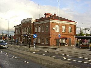
Ronneby Train Station
|
||
|
||
 |
||
| Country | Sweden | |
| County | Blekinge County | |
| Seat | Ronneby | |
| Area | ||
| • Total | 1,247.86 km2 (481.80 sq mi) | |
| • Land | 829.8 km2 (320.4 sq mi) | |
| • Water | 418.06 km2 (161.41 sq mi) | |
| Area as of January 1, 2010. | ||
| Population
(June 30, 2012)
|
||
| • Total | 28,339 | |
| • Density | 22.7101/km2 (58.8188/sq mi) | |
| Time zone | UTC+1 (CET) | |
| • Summer (DST) | UTC+2 (CEST) | |
| ISO 3166 code | SE | |
| Province | Blekinge | |
| Municipal code | 1081 | |
| Website | www.ronneby.se | |
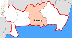
Ronneby Municipality (Ronneby kommun) is a special area in Blekinge County in southern Sweden. It is like a local government area. It shares borders with Tingsryd Municipality, Emmaboda Municipality, Karlskrona Municipality, and Karlshamn Municipality. The main town and center of the municipality is Ronneby.
This municipality was formed in 1967. It was created when the old City of Ronneby joined together with three areas around it.
Contents
Towns and Villages
Ronneby Municipality has 8 main urban areas, also known as localities or Tätorter. These are places where many people live close together.
The table below lists these areas by how many people lived there on December 31, 2010. The main town, Ronneby, is shown in bold.
| # | Locality | Population |
|---|---|---|
| 1 | Ronneby | 12,029 |
| 2 | Kallinge | 4,561 |
| 3 | Bräkne-Hoby | 1,689 |
| 4 | Johannishus | 748 |
| 5 | Listerby | 883 |
| 6 | Backaryd | 365 |
| 7 | Eringsboda | 299 |
| 8 | Hallabro | 254 |
Local Church Areas
In Sweden, parishes are old church areas that are sometimes still used for local organization. Here are the parishes in Ronneby Municipality, grouped by their larger historical areas called hundreds:
Bräkne Hundred
- Bräkne-Hoby Parish
- Öljehult Parish
Medelstad Hundred
- Backaryd Parish
- Edestad Parish
- Eringsboda Parish
- Förkärla Parish
- Hjortsberga Parish
- Listerby Parish
- Ronneby Parish
International Friends
Ronneby Municipality has special friendships with towns and areas in other countries. These are called twin towns or sister cities. They often work together on projects and learn from each other.
 Bornholm, Denmark
 Mänttä, Finland
 Steglitz-Zehlendorf, Germany
 Schopfheim, Germany
 Høyanger, Norway
 Elbląg, Poland
 Slavsk, Russia
 Enfield, Connecticut, United States
 Johnson City, Tennessee, United States
See also
 In Spanish: Municipio de Ronneby para niños
 | Mary Eliza Mahoney |
 | Susie King Taylor |
 | Ida Gray |
 | Eliza Ann Grier |


