
Ropewalks, Liverpool facts for kids
Quick facts for kids Ropewalks, Liverpool |
|
|---|---|
.jpg)       Clockwise from top: Bold Street; Concert Square; Fleet Street; Slater Street; Fleet Street; David Lewis Street and Church of St Luke |
|

Ropewalks, Liverpool
|
|
| OS grid reference | SJ3488589995 |
| Metropolitan borough | |
| Metropolitan county | |
| Region | |
| Country | England |
| Sovereign state | United Kingdom |
| Post town | Liverpool |
| Postcode district | L1 |
| Dialling code | 0151 |
| Police | Merseyside |
| Fire | Merseyside |
| Ambulance | North West |
| EU Parliament | North West England |
| UK Parliament |
|
Ropewalks is a cool area in Liverpool city centre. It's bordered by streets like Hanover Street and Roscoe Street.
This part of the city is full of life! You'll find unique shops, cozy cafes, tasty restaurants, and lots of places for fun at night. Some well-known streets here include Bold Street, Wood Street, and Seel Street. It's also home to Liverpool's Chinatown.
Contents
History of Ropewalks
The name "Ropewalks" comes from the old days when people made ropes here. This was a big business for sailing ships until the 1800s. The streets in this area are long and straight, running next to each other. This design helped rope makers lay out long ropes while they were being made.
Ropes were made in fields, but rope makers would buy or rent long, thin pieces of land. When these strips of land were sold one by one, it led to the long, thin streets we see today. The streets themselves weren't used for making ropes; the rope-making areas were there before the streets.
Cool Streets and Landmarks
Bold Street

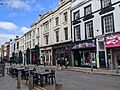
Today, Bold Street is famous for its creative vibe. You'll see tourists, street performers, and unique independent shops. There are also many restaurants serving food from different cultures.
But this street started as a "ropewalk" in the 1600s and early 1700s. It was used to measure and cut long ropes for ships. The street was the perfect length for the ropes needed for large sailing ships. Later, in the 1800s, it was renamed Bold Street after Jonas Bold. He was a wealthy merchant and banker who became the Lord Mayor of Liverpool in 1802.
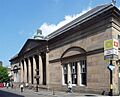
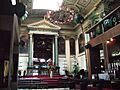
At the end of Bold Street is The Lyceum Building. This historic building was built in 1802. It was first used as a newsroom and England's very first library where people paid a fee to join. In 2001, an old well from the 1600s was found during building work on Bold Street. Experts believe the well was built when the area was still open fields. People would have used it for drinking water. Today, you can see the well inside a vintage fashion shop called Soho's.
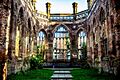
The Bombed-Out Church

The 'bombed-out church' is officially called St Luke’s Church. It's at the top of Bold Street, where Leece Street and Berry Street meet. The church opened in 1832. It was badly damaged during the May Blitz of 1941. Liverpool was a major port and industrial city, so it was a target during the war. It was one of the most bombed places outside of London.
After a huge fire, only the outside walls of the church were left standing. The site was left empty and overgrown for over 60 years. In the 2000s, it was finally cleaned up and opened to the public. Today, it's a memorial to those affected by war. It also hosts many community arts and cultural events. These events include plays, dance shows, music, art displays, and outdoor movies.
Chinatown


Chinatown, Liverpool is home to the oldest Chinese community in Europe. It's famous for its Chinese restaurants, takeaways, supermarkets, and cultural places. You can see signs of Chinese culture everywhere. There's the Liverpool Chinese Business Association, the Pagoda Youth Orchestra, and street signs in Chinese.
Liverpool's four universities attract thousands of Chinese students each year. In 2021, Liverpool had the third largest Chinese population in England and Wales, outside of London. Liverpool also has the biggest Chinese arch outside of China. It was a gift from its sister city, Shanghai. This arch marks the entrance to today's Chinatown on Nelson Street.
Since the 1800s, especially during the two world wars, Liverpool's role as a big port created strong links with Shanghai and Hong Kong. Cargo ships bringing silk, cotton, and tea from China started arriving in Liverpool in the 1830s. Chinese immigrants began arriving in the 1860s. By the 1890s, a Chinese community grew around the city's docks. Chinese sailors started businesses, like boarding houses, for others who spoke their language. Some Chinese sailors married local women. This created the first British-born Chinese community in Liverpool. The first Chinatown was near the docks. Later, some sailors settled on Cleveland Square and Pitt Street, creating a new Chinatown.
After World War I, the Chinese population moved further inland. Many Chinese-owned food businesses opened on Pitt Street. Laundry businesses also started around the city. The tough economic times of the 1930s affected shipping. This led to a decline in the new Chinatown. Many buildings were left empty and damaged.
Thousands more Chinese people came to Liverpool during World War II. Sailors were hired for the British Merchant Navy from Shanghai, Singapore, and Hong Kong. Most were stationed in Liverpool. As a major port, Liverpool was vital for moving goods, food, and supplies. However, the community had to leave their homes during the bombings of World War II. Both the new and old dockland Chinatowns were destroyed. Pitt Street and Frederick Street were ruined. The Chinese community moved further inland to Nelson Street and Duke Street. These areas are still part of modern-day Chinatown today.
Concert Square

Since the 1990s, Concert Square has been one of Liverpool's main spots for outdoor drinks and nightlife. The square and nearby area have old warehouses and new buildings that are now bars and clubs. Many tourists from the UK and other countries visit for fun. Big events like important football matches or the start of the new university year in September are very busy times. Baa Bar on Fleet Street, near the square, was one of the first bars to make this area popular for nightlife.
FACT Liverpool


FACT Liverpool (Foundation for the Arts and Creative Technologies) is an important cultural place in the UK. It's on Wood Street. Opened in 2003, FACT is a special building for arts. It has art galleries, a space for media and events, a lab for learning, a Picturehouse cinema, and a bar. FACT shows and creates video, digital art, and films. The building was designed by architect Austin-Smith:Lord. Millions of people visit every year. It has hosted famous international guests and Hollywood stars. FACT also takes part in Liverpool Biennial, a big art festival that shows art from all over the world.
Wolstenholme Square
Wolstenholme Square was built on land owned by the Wolstenholme family. In the 1700s, it was a fancy place for some of Liverpool's richest merchants to live. They had great views of the River Mersey and the Wirral Peninsula.
More recently, the square has changed a lot. In the late 1980s, it had many run-down warehouses. From the 1990s to the 2000s, it became home to nightclubs and rave parties. Famous clubs like Nation (which hosted the global club brand Cream), Pleasure Rooms, and The Kazimier club were here.
Since the 2000s, the Ropewalks area has seen more homes being built. In 2016, the nightclubs were closed down to make way for new buildings. Now, there are new apartment blocks and shops in Wolstenholme Square. However, Kazimier Garden is still open nearby on Seel Street, as a bar and garden. The Kazimier club itself moved to the Invisible Wind Factory in another part of Liverpool. In the middle of Wolstenholme Square, you can see an art sculpture called 'Penelope'.
Other Streets
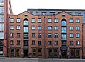
Other important streets in this area include Slater Street, Fleet Street, and Wood Street. These are key parts of Liverpool's nightlife today. Duke Street has many places to eat and drink, plus boutique hotels.
Where is Ropewalks?
Ropewalks is right next to Liverpool city centre's main shopping area. It's surrounded by streets like Hanover Street, Leece Street, and Duke Street. Liverpool Central railway station is at its northern edge. The Church of St Luke, Liverpool (the 'Bombed-out church') is on the eastern side. To the southeast is Great George Street Congregational Church ('The Blackie').
According to Liverpool's latest plan, Liverpool City Council has set aside Ropewalks for creative and digital businesses. It's also for entertainment, nightlife, homes, small shops, hotels, cultural places, restaurants, and offices.
 |
Liverpool One | Main Retail Area, Cultural Quarter | Knowledge Quarter | |
| Baltic Triangle | Georgian Quarter | |||
| Baltic Triangle | Baltic Triangle | Toxteth |

List of Notable Landmarks
- Blue Angel (nightclub)
- Casartelli Building
- Church of St Luke, Liverpool ('Bombed-out church')
- City of Liverpool College (Duke Street and Roscoe Street}
- Epstein Theatre
- FACT Liverpool
- Great George Street Congregational Church ('The Blackie')
- Jacaranda Records
- Liverpool Central railway station
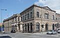
- Liverpool Royal Institution
- News From Nowhere (bookshop)
- St Peter's Roman Catholic Church
- The Jacaranda
- The Lyceum
- The Whitehouse
Gallery
-
Parr Street
-
Gradwell Street
-
Hanover Street
-

Corner of Duke Street and Hanover Street
-
24 Hanover Street
-
Union News Room
-
26 - 30 Hanover Street
-

167 - 171 Duke Street, Liverpool 1.jpg
-
The 'Bombed-out church'
-
The Lyceum, Bold Street
-
Wood Street
-
Alma de Cuba
-
Bold Street (top)
-
Hanover Street marks the boundary of RopeWalks
-
St Peter's, Seel Street


_Liverpool2.jpg)
.jpg)


.jpg)
.jpg)

