
Rothenfluh facts for kids
Quick facts for kids
Rothenfluh
|
||
|---|---|---|
 |
||
|
||

Rothenfluh
Location in Switzerland

Rothenfluh
Location in Canton of Basel-Landschaft
|
||
| Country | Switzerland | |
| Canton | Basel-Landschaft | |
| District | Sissach | |
| Area | ||
| • Total | 10.95 km2 (4.23 sq mi) | |
| Elevation | 471 m (1,545 ft) | |
| Population
(Jun 2021 )
|
||
| • Total | 770 | |
| • Density | 70.3/km2 (182.1/sq mi) | |
| Postal code |
4467
|
|
| Surrounded by | Anwil, Hemmiken, Oltingen, Ormalingen, Wegenstetten (AG), Wenslingen, Wittnau (AG) | |

Rothenfluh is a small town, also called a municipality, located in Switzerland. It is part of the canton of Basel-Country and belongs to the Sissach district.
Contents
A Look at Rothenfluh's Past
Rothenfluh was first mentioned in official records way back in 1196. Back then, it was called Rotenfluo.
How Rothenfluh Grew Over Time
Did you know Rothenfluh started as seven different small villages? These villages were Loglingen, Hendschikon, Söllickken, Werlickhen, Hohlwingen, Gastwingen, and Werdlingen. Over time, most of these villages became less populated. Loglingen grew and eventually became the Rothenfluh we know today.
In the 12th century, different parts of the area were owned by powerful groups. Some land belonged to the Catholic Bishop of Basel. Other parts were controlled by the Habsburg family, who were very important rulers in Europe.
Becoming Part of Switzerland
In the 1500s, Rothenfluh joined the Helvetic Confederation. This was an early form of what is now Switzerland. It became part of the Gelterkinden district. Later, in 1803, it officially became a municipality within the Sissach district.
Originally, there were two Catholic churches in the area, dedicated to St. Stephan and St. Georg. These two church communities joined together in the 13th century.
Exploring Rothenfluh's Geography

Rothenfluh covers an area of about 10.93 square kilometers (about 4.2 square miles). A large part of this land is covered by forests, making up about 55.8% of the area. Another big part, about 39.8%, is used for farming. This includes fields for crops and pastures for animals.
Only a small portion, about 3.8%, has buildings and roads. This shows that Rothenfluh is a very green and natural place!
Where Rivers Meet
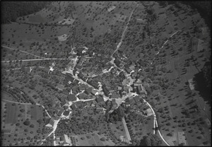
The town of Rothenfluh has a unique ring shape. It is located where two rivers, the Ergolz and the Dübach, flow together. This meeting point of rivers is called a confluence.
Understanding the Coat of Arms
The town's official symbol, its coat of arms, has a special design. It shows a red stone (monolith) between two green pine trees. These trees grow from green hills at the bottom. This design is called Or, a Monolith Gules between two Pine trees Vert issuant from Coupeaux of the same.
Who Lives in Rothenfluh?


Rothenfluh has a population of about 766 people. Most people in Rothenfluh speak German, which is the main language. A smaller number of people speak French or Italian language.
Age Groups in Rothenfluh
The population of Rothenfluh includes people of all ages. About 6.1% are young children (0-6 years old). Teenagers (7-19 years old) make up about 16.2% of the population. Adults are the largest group, with people aged 20-64 making up a big part of the community. There are also many senior citizens, with about 9.5% aged 65-79 and 6.1% over 80 years old.
Homes and Families
In Rothenfluh, there are about 256 households. On average, about 2.7 people live in each home. Some homes have only one person, while others are larger families with five or more people. Many homes are families with married couples, some with children and some without.
What to See in Rothenfluh
The entire village of Rothenfluh is recognized as an important historical area. It is part of the Inventory of Swiss Heritage Sites, meaning it has special cultural value.
How Rothenfluh Makes a Living
Rothenfluh has different types of jobs and businesses.
Main Job Sectors
- Primary Sector: This includes jobs related to nature, like farming and forestry. About 63 people work in this area in Rothenfluh.
- Secondary Sector: These jobs involve making things, like in factories or construction. About 37 people work in this sector.
- Tertiary Sector: This is the service sector, including jobs in shops, restaurants, education, and healthcare. About 64 people work in these types of jobs.
Many people who live in Rothenfluh travel to other towns for work. About 18.3% use public transport, and 44.2% use a private car to get to their jobs.
Religion in Rothenfluh

Most people in Rothenfluh belong to the Swiss Reformed Church, which is a Protestant Christian church. A smaller number of people are Roman Catholic. There are also people who follow other Christian faiths, Islam, Buddhism, or Hinduism. Some people do not belong to any church.
Learning and Education
In Rothenfluh, many adults have completed their high school education. About 11.1% of the population has gone on to get higher education, like a university degree.
Some students from Rothenfluh attend schools in other towns nearby.
See also
 In Spanish: Rothenfluh para niños
