
Roxas Boulevard facts for kids
Roxas Boulevard is a famous wide road in Manila, the capital city of the Philippines. It stretches along the beautiful shores of Manila Bay. People love it for its amazing sunset views and the long line of coconut trees that grow along its side.
This boulevard has become a well-known spot for tourism. It's also home to many interesting places like a yacht club, fancy hotels, tasty restaurants, busy commercial buildings, and fun parks.
Quick facts for kids
|
|
|---|---|

Map of Roxas Boulevard in Metro Manila
|
|

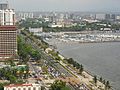
Roxas Boulevard along the Manila Bay
|
|
| Route information | |
| Maintained by Department of Public Works and Highways | |
| Length | 7.6 km (4.7 mi)
from Google Earth
|
| Existed | 1910s–present |
| Component highways |
|
| Restrictions | No trucks, trailers, and buses from Padre Burgos Avenue/Katigbak Parkway to Gil Puyat Avenue. |
| Major junctions | |
| North end | Padre Burgos Avenue in Ermita |
|
|
| South end | |
| Location | |
| Major cities: | Manila, Pasay, Parañaque |
| Highway system | |
Roads in the Philippines
|
|
_sign.svg)
.svg)
Contents
How Roxas Boulevard Got Its Name
.jpg)
Roxas Boulevard has had a few different names over the years!
From Cavite to Dewey
When it was first built, this road was called Cavite Boulevard. Later, its name was changed to Dewey Boulevard. This new name honored George Dewey, an American Admiral. Admiral Dewey and his navy won an important battle against the Spanish navy in Manila Bay in 1898.
Changes During Wartime
During the Japanese occupation of the Philippines in 1941, the road's name was changed again to "Heiwa Boulevard." "Heiwa" means "peace" in Japanese.
Named After a President
Finally, in the 1960s, the boulevard was renamed Roxas Boulevard. This was to honor Manuel Roxas, who was a former president of the Philippines.
More to Explore
Images for kids
-

Daniel Burnham's plan for the sea boulevard from Manila to Cavite
-

Construction of Cavite Boulevard in 1912
-

An aerial view of Dewey Boulevard in 1931
-

The historic Rizal Park is at the northern end of the boulevard
-

The Malate section of Roxas Boulevard is known for Baywalk and Plaza Rajah Sulayman
-

Manila's Baywalk along Roxas Boulevard
-
Roxas Boulevard looking south, showing the Manila Yacht Club and the Cultural Center of the Philippines Complex
-

Roxas Boulevard looking north from the Baclaran area in Pasay


.jpg)


