
Sabiñánigo facts for kids
Quick facts for kids
Sabiñánigo
Samianigo (Aragonese)
|
|||
|---|---|---|---|

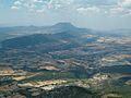
View of Sabiñánigo from Mount Santa Orosia
|
|||
|
|||

Municipal location within the Comarca of Alto Gállego and Province of Huesca.
|
|||

Sabiñánigo
Location in Spain
|
|||
| Country | |||
| Autonomous community | Aragon | ||
| Province | Huesca | ||
| Comarca | Alto Gállego | ||
| Area | |||
| • Total | 586.82 km2 (226.57 sq mi) | ||
| Elevation | 780 m (2,560 ft) | ||
| Population
(2018)
|
|||
| • Total | 9,245 | ||
| • Density | 15.7544/km2 (40.8037/sq mi) | ||
| Time zone | UTC+1 (CET) | ||
| • Summer (DST) | UTC+2 (CEST) | ||
| Website | [1] | ||


Sabiñánigo (called Samianigo in Aragonese) is a town in Spain. It is a municipality in the province of Huesca, which is part of the Aragon region. Sabiñánigo is the capital of the comarca (a type of region) called Alto Gállego.
The town is located 780 meters (about 2,559 feet) above sea level. It is about 52 kilometers (32 miles) away from Huesca, the capital city of the province. In the past, this area was known as Serrablo. Because of this, people from Sabiñánigo are sometimes called "serrablese."

Sabiñánigo shares borders with several other towns. To the north, it borders Biescas and Yebra de Basa. To the east, it borders Fiscal and Boltaña. To the south, it borders Las Peñas de Riglos and Somontano de Barbastro. To the west, it borders Caldearenas, Jaca, and Villanúa.
Contents
Where Did the Name Sabiñánigo Come From?
The first official mention of Sabiñánigo was in the year 1035. It was written as "Savignaneco" back then. The name comes from an old Latin name, "Sabinianicu." This name itself came from "Sabinianus," which was from "Sabinius" or "Sabinus." Over time, in the Aragonese language, the name changed to "Samianigo."
Exploring the Geography of Sabiñánigo
Sabiñánigo is the main town in the Alto Gállego region. It is about 52 kilometers from the capital of its province. Important roads like the N-260 and N-330 pass through the municipality. There are also local roads that connect Sabiñánigo to nearby villages and towns like Jaca and Caldearenas. The A-1604 road goes through the Serrablo Valley towards Boltaña.
The area around Sabiñánigo has many valleys and mountains. These include the Acumuer and Aurín Valleys to the northwest, the Gállego Valley running north to south, and the Basa and Serrablo (or Guarga) Valleys to the east and south. To the north are the Pyrenees mountains. To the south are the pre-Pyrenean mountains like San Pedro (1212 m) and Belarre (1467 m). The highest point in the municipality is Peña Retona, at 2764 meters (about 9,068 feet). The lowest point is 665 meters (about 2,182 feet) by the Gállego River.
Part of the municipality is within the Sierra Guara and Canyons of Guara Natural Park. This park is famous for its beautiful canyons. The town itself sits on the right side of the Gállego River, at an altitude of 780 meters.
| Northwest: Canfranc and Villanúa | North: Sallent de Gállego and Biescas | Northeast: Biescas and Yebra de Basa |
| West: Jaca |  |
East: Fiscal and Boltaña |
| Southwest: Caldearenas | South: Nueno | Southeast: Bierge |
A Look at Sabiñánigo's History
Early History and Roman Times
Sabiñánigo's story began with the Roman Empire. Around the 2nd century, the Romans built a military outpost here. This outpost was on a road that connected Osca (today's Huesca) with the hot springs of Panticosa. In 1972, the town celebrated its 2000th anniversary. This was based on the idea that Calvisio Sabino, a Roman leader, founded "Sabiniano."
The Middle Ages and Royal Status
The first written record of Sabiñánigo is from 1035. It mentions the town becoming part of the Kingdom of Aragon. By 1137, Sabiñánigo was known as a "royal town." This meant it had special rights and was not controlled by a local lord. This special status continued for centuries.
In 1206, King Pedro II gave the church of San Acisclo to the bishop of Jaca-Huesca. Later, in 1492, Ferdinand the Catholic helped settle land disputes in the area.
Modern Times and Growth
In the 16th century, Sabiñánigo started to grow economically. By the late 1800s, a railway was being built to connect Zaragoza with France. When the train arrived in 1893, a station was built near Sabiñánigo. A new part of town, called "Barrio de la Estación" (Station Quarter), grew around it. Shops and places to stay opened up.
This new area became very important. People traveling to the famous Panticosa hot springs would arrive by train in Sabiñánigo. From there, they would take carriages or buses to the spa. In 1916, the town hall even moved to the Barrio de la Estación.
Factories helped the town grow even more. In 1920, a company called Energía e Industrias Aragonesas (EIASA) built a chemical factory. This factory was very important because it was the first in the world to make ammonia from hydrogen. Soon after, another company, AESA, started making aluminum. It was the first Spanish company to do so.
Recent History and Changes
In the 1950s and 1960s, Sabiñánigo grew by adding many smaller villages to its municipality. These included Sardas, Cartirana, Acumuer, and many others.
During the Spanish Civil War, from September to November 1937, a big battle happened near Sabiñánigo. It was called the Battle of Sabiñánigo. The Republican army tried to capture the town, which was an important industrial center. However, they were not successful. Around 6,000 soldiers were injured or lost their lives in this battle.
In the 2000s, some factories closed or reduced their workers. However, Sabiñánigo still has important companies. Many young people have moved to Sabiñánigo, making it one of the youngest towns in Aragon.
Villages in Sabiñánigo Municipality
The municipality of Sabiñánigo includes many small villages. In 2004, all these villages together had a population of 977 people. Some of these villages are:
- Abellada
- Abenilla
- Acumuer
- Aineto
- Alavés
- Allué
- Arguisal
- Arraso
- Arruaba
- Arto
- Artosilla
- Aspés
- Asqués
- Asún
- Atós Alto
- Atós Bajo
- Aurín
- Bara
- Baranguá
- Belarra
- Bentué de Nocito
- Bolás
- Borrés
- Campares
- Cañardo
- Cartirana
- Castiello de Guarga
- Castillo de Lerés
- Ceresola
- Fablo
- Fenillosa
- Gésera
- Gillué
- Grasa
- Hostal de Ipiés
- Ibirque
- Ibort
- Ipiés
- Isín
- Isún de Basa
- Jabarrella
- Laguarta
- Lanave
- Lárrede
- Larrés
- Lasaosa
- Lasieso
- Latas
- Latrás
- Layés
- Molino de Escartín
- Molino de Villobas
- Ordovés
- Orna de Gállego
- Osán
- Pardinilla
- El Puente de Sabiñánigo
- Rapún
- Sabiñánigo Alto
- San Esteban de Guarga
- San Román de Basa
- Sandiás
- Santa María de Perula
- Sardas
- Sasal
- Satué
- Secorún
- Senegüé
- Solanilla
- Sorripas
- Used
- Villacampa
- Yéspola
Population of Sabiñánigo
As of 2023, Sabiñánigo has a population of 9,423 people.
| 1991 | 1996 | 2001 | 2003 | 2007 | 2008 | 2011 | 2021 | 2023 |
|---|---|---|---|---|---|---|---|---|
| 9,056 | 8,759 | 8,578 | 8,797 | 9,673 | 10,112 | 10,164 | 9,360 | 9,423 |
In 1900, Sabiñánigo had only 280 residents. When factories were built, many new jobs appeared. People moved to Sabiñánigo to fill these jobs. By 1940, the population grew to 1,768. In 1960, it reached 6,184. Even though some factories have closed, Sabiñánigo still has many active businesses. Thanks to young people moving to the town, Sabiñánigo has one of the youngest populations in Aragon.
Sports, Culture, and Tourism in Sabiñánigo

Sabiñánigo is well-known for its connection to sports, especially cycling. It hosts "The Quebrantahuesos," which is one of the most important amateur cycling races in the world. The town is also often a starting or finishing point for the Vuelta a España, a major professional cycling race.
Sabiñánigo is a great place for skiing. It is close to several popular ski resorts:
- 30 km (18.6 miles) from Panticosa
- 38 km (23.6 miles) from Formigal (the largest ski resort in Spain)
- 44 km (27.3 miles) from Candanchú
- 47 km (29.2 miles) from Astún
- 120 km (74.5 miles) from Cerler
There are also interesting places to visit in Sabiñánigo:
- The Museo de Artes de Serrablo es is a museum. It shows tools, clothes, and other traditional items from the region.
- Pirenarium es is a theme park. It has many models of the Pyrenees mountains and famous buildings from Aragón.
The local football team is AD Sabiñánigo.
Sister Cities
Sabiñánigo has special connections with other towns around the world. These are called "sister cities."

| Town | State/Region | Country |
|---|---|---|
| Billère | Occitania | |
| Petersberg | Hesse | |
| Breitungen | Thuringia | |
| Cisek | Opole Voivodeship |
Images for kids
-
View of Sabiñánigo from Mount Santa Orosia
See also
 In Spanish: Sabiñánigo para niños
