
Saddle Mountain (Clatsop County, Oregon) facts for kids
Quick facts for kids Saddle Mountain |
|
|---|---|
 |
|
| Highest point | |
| Elevation | 3,288 ft (1,002 m) NAVD 88 |
| Prominence | 2,323 ft (708 m) |
| Listing | Oregon county high points |
| Geography | |

Saddle Mountain
Location in Oregon
|
|
| Parent range | Northern Oregon Coast Range |
| Topo map | USGS Saddle Mountain |
| Climbing | |
| First ascent | 1841 by James Dwight Dana |
| Easiest route | Trailhead from state park |
Saddle Mountain is the highest mountain in Clatsop County, Oregon, in the U.S.. It's part of the Oregon Coast Range and is located within the beautiful Saddle Mountain State Natural Area in the northwest part of Oregon. This special mountain is even listed on Oregon's Register of Natural Heritage Resources because of its unique features.
Contents
How Saddle Mountain Was Formed
.jpg)
Saddle Mountain was created about 15 million years ago. This happened during a time called the Miocene epoch, which was a long time ago! During this period, hot lava flowed down the old Columbia River valley.
When the lava reached the water of the ancient Astoria Sea, it caused huge steam explosions. These explosions and sudden cooling created a big pile of basalt rocks. Basalt is a common type of volcanic rock. Saddle Mountain is made of a rock called volcanic breccia. This breccia is made of broken pieces of basalt that are stuck together tightly.
Mountain History and Explorers
Many European and American explorers have seen and written about Saddle Mountain. The first known explorer was British captain John Meares in 1788. He named the peak Mont de la Selle, which means "Mountain of the Saddle" in French.
Later, the famous Lewis and Clark Expedition saw the mountain in 1805. The United States Exploring Expedition, led by Charles Wilkes, also explored the area in 1841. It was during this expedition that James Dwight Dana made the first recorded climb to the top of Saddle Mountain.
Hiking to the Top
The hike to the taller of Saddle Mountain's two peaks is a challenging adventure. It's a 6-mile (about 9.7 km) round trip. You will climb about 1,603 feet (489 meters) in elevation.
When you reach the top, you get an amazing 360-degree view! You can see the Pacific Ocean and several peaks from the Cascade Mountains. These include Mount Hood, Mount St. Helens, Mount Rainier, and Mount Adams. You can also see other mountains in the Coast Range.
The lower peak, which is about 3,200 feet (975 meters) high, does not have a trail. The main trail to the taller peak can be steep in some places, especially along rocky areas. However, it offers beautiful views, and you can see many wildflowers blooming in the springtime. Near the start of the trail, there's a picnic area and a simple campground.
Saddle Mountain is about 7 miles (11 km) off U.S. Route 26. This is about 65 miles (105 km) west of Portland. The road leading to the mountain and state park is paved. The area around the mountain has thick forests of spruce and hemlock trees. You can also see some very old lava flows.
Images for kids
-
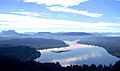
Saddle Mountain on the left overlooking Youngs River.

