Sahuarita, Arizona facts for kids
Quick facts for kids
Sahuarita, Arizona
|
||
|---|---|---|
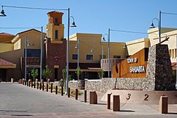
Sahuarita Town Hall
|
||
|
||
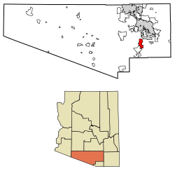
Location of Sahuarita in Pima County, Arizona.
|
||
| Country | ||
| State | ||
| County | Pima | |
| Founded | 1911 | |
| Incorporated | 1994 | |
| Government | ||
| • Type | Council-manager | |
| • Body | Sahuarita Town Council | |
| Area | ||
| • Total | 31.68 sq mi (82.06 km2) | |
| • Land | 31.68 sq mi (82.06 km2) | |
| • Water | 0.00 sq mi (0.00 km2) | |
| Elevation | 2,703 ft (824 m) | |
| Population
(2020)
|
||
| • Total | 34,134 | |
| • Density | 1,077.36/sq mi (415.97/km2) | |
| Time zone | UTC-7 (MST (no DST)) | |
| ZIP code |
85629
|
|
| Area code(s) | 520 | |
| FIPS code | 04-62140 | |
| GNIS feature ID | 33948 | |
| Website | http://www.sahuaritaaz.gov/ | |
Sahuarita is a town in Pima County, Arizona, United States. It is located south of the Tohono O'odham Nation and next to the northern part of Green Valley. Sahuarita is about 15 miles (24 km) south of Tucson. In 2022, the population was estimated to be 35,638 people.
Contents
- History of Sahuarita
- Early People: Hohokam (200–1450)
- Sobaipuri People (1400–1900)
- Spanish and Mexican Rule (1775–1853)
- Becoming Part of the U.S. (1854–1874)
- Sahuarita Appears on Maps (1870–1925)
- Sahuarita Ranch (1879–1886)
- Continental Farm (1915–present)
- World War II (1941–1945)
- Sahuarita Bombing and Gunnery Range (1942–1978)
- Cold War Era
- Population Growth
- Geography and Environment
- Economy and Jobs
- Neighborhoods and Parks
- Education
- Transportation
- See also
History of Sahuarita
Sahuarita was officially founded in 1911 and became an incorporated town in 1994. This means it became an official town with its own local government.
Early People: Hohokam (200–1450)
The first people known to live in the Sahuarita area were the Hohokam. They might be the ancestors of today's Tohono O'odham nation. The Hohokam were very skilled at using irrigation to water their crops. They were also peaceful and traded with people far away, even in Mesoamerica (which is now Mexico and Central America).
Sobaipuri People (1400–1900)
The Sobaipuri people were possibly related to the Hohokam. They lived in the southern part of the Santa Cruz Valley. In 1691, a Spanish explorer named Eusebio Kino traveled along the Santa Cruz River and met the Sobaipuri leaders. Kino was a supporter of the Native American people and was against forcing them to work in mines. He later started the Mission San Xavier del Bac in 1699, which is just north of Sahuarita.
Spanish and Mexican Rule (1775–1853)
In 1775, after building several missions, the Spanish set up a fort in the Tucson area. This helped them control the Native American settlements nearby. This also put the Sahuarita region under Spanish control. Later, Tucson grew into a town. After Mexico gained independence from Spain in 1821, the region became part of Mexico. However, Mexico later sold this land to the United States in 1853 as part of the Gadsden Purchase.
Becoming Part of the U.S. (1854–1874)
In 1854, Sahuarita became part of the New Mexico Territory in the United States. During this time, Native American groups were often forced to move from their lands. In 1874, the San Xavier reservation was created, which is now called the Tohono O'odham Reservation. Native Americans were moved there.
Sahuarita Appears on Maps (1870–1925)
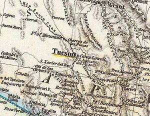
An 1870 map of Arizona showed an "Indian Village" just north of Sahuarita. The first time the town was clearly named on a map was in 1875, on a German map that called it "Sahuarito". The first U.S. map to show the town was in 1879, from the U.S. Department of Interior, calling it "Saurita". This name appeared on maps in 1880 and 1890 too.
By 1925, a map of "Auto Trails" (roadways) in Arizona and New Mexico listed "Continental" instead of Sahuarita. This road was an "improved road," which was almost as good as a "paved road." It followed the path of what is now called the Old Nogales Highway.
Sahuarita Ranch (1879–1886)
In 1879, James Kilroy Brown started Sahuarita Ranch. He named it Sahuarita because there were many saguaro cacti in the area. The ranch was a stopover point for travelers between Tucson, Arivaca, and Quijotoa. A small community called Sahuarito grew there. A railroad also laid tracks through the area, which are still there today, and built a station and post office.
Continental Farm (1915–present)
The Continental Farm has been a big part of Sahuarita's history. In 1915, some important people like Bernard Baruch and J.P. Morgan started the farm. They hoped to grow guayule, a plant that provides rubber, because they were worried about getting rubber from other countries during World War I. This project ended after the war.
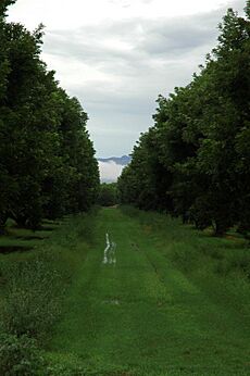
In 1922, the farm was sold to Queen Wilhelmina of the Netherlands. The Queen rented the land to farmers who grew cotton for the next 40 years. In 1948, R. Keith Walden moved his Farmers Investment Co. (FICO) to Arizona and bought the Continental Farm lands from the Queen. In 1965, he changed the main crop to pecans. Today, the FICO pecan orchard is the largest in the world, with over 6,000 acres (24 km²) and 106,000 trees!
World War II (1941–1945)
During World War II, Sahuarita had the Sahuarita Airstrip. This airstrip was used to train bomber pilots for the war. There was also a labor camp for German prisoners of war called Camp Continental. This camp was located near what is now Continental Ranch. About 250 prisoners worked in agriculture, growing cotton and vegetables. Some prisoners tried to escape, but they were all caught.
Sahuarita Bombing and Gunnery Range (1942–1978)
The United States Army Air Corps used this large area (27,046 acres or 109 km²) for practice bombing runs starting in 1942. The Sahuarita Flight Strip, with a 5,540-foot (1,689 m) paved runway, was finished in 1943. Bombing runs stopped for a while but started again in 1950 and continued until 1962. The airstrip was kept for emergency landings.
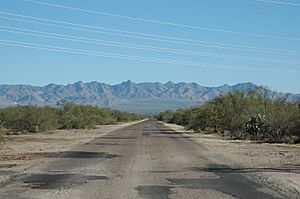
In 1978, the government gave the land to Arizona, which then leased it to a cattle rancher. The old airstrip is now a road that leads to "Sahuarita Park." The rest of the land is still used for cattle.
The U.S. Army Corps of Engineers is still working to find and remove any old ammunition from the area. They also protect endangered animals like jaguars and spotted owls that live there. You can still find pieces of old ammunition and shrapnel from bombs on the range. The actual airstrip is now a road used to get to Sahuarita Park and the Edge Charter School.
Cold War Era
Sahuarita is home to the Titan Missile Museum. This museum was built in 1963 during the Cold War, a time of tension between the U.S. and the Soviet Union. It is the only Titan Missile site in the world that the public can visit. The actual Titan II missile, which was a very powerful nuclear missile, is still in its underground silo for visitors to see. The Sahuarita Airstrip was also used by the U.S. Air Force during most of the Cold War.
Population Growth
Sahuarita has grown a lot over the years!
- In 1990, the population was 1,629 people.
- By 2000, it grew to 3,242 people.
- In 2010, the population jumped to 25,259 people.
- By 2020, it reached 34,134 people.
This shows a huge increase in the number of people living in Sahuarita!
Who Lives in Sahuarita?
According to the 2010 census, there were 25,259 people living in Sahuarita.
- About 29.7% of the people were under 18 years old.
- About 55.5% were between 18 and 64 years old.
- About 14.7% were 65 years or older.
- The population was 51.2% female and 48.8% male.
Many people living in Sahuarita have a good education. A survey in 2007 showed that many residents had college degrees, more than the average for the county or state. Most people who live in Sahuarita work in Tucson, but many also work in Sahuarita or Green Valley.
Geography and Environment
Sahuarita is located at 31.929245 degrees North latitude and -110.982241 degrees West longitude. The town covers about 30 square miles (78 km²). The Santa Cruz River (Arizona) flows through this desert town, usually during the monsoon season (rainy season).
Water in the Desert
Since Sahuarita is in the desert, having enough water is a big deal. A report from 2007 showed that a lot of water was pumped from the underground water supply (aquifer) in the Upper Santa Cruz Valley. Most of this water was used for mining and farming. The report warned that the water supply might become "critical" within ten years if people kept using water at the same rate.
Sahuarita Lake
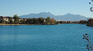
Sahuarita Lake is a man-made lake that was finished in 2001. It is about 1 mile (1.6 km) long around its edge and about 10 feet (3 m) deep. The lake holds about 70 acre-feet of water.
The lake is "managed," which means people work to keep its water clean and healthy. Air pumps under the lake keep the water moving and mixed, which helps keep the lake balanced. The lake has fish and frogs, and it attracts ducks and other birds.
The lake needs to be refilled every year because water evaporates and seeps into the ground. About 65 gallons of water per minute must be pumped into the lake to keep its level steady. This water comes from a nearby well that uses the same underground water supply as the rest of the area.
Economy and Jobs
The Grupo México Asarco's Mission Complex mine is located in Sahuarita and is one of the town's biggest employers. This means it provides many jobs for people in the area.
Main Employers
Here are some of the largest employers in Sahuarita:
- Sahuarita Unified School District: This includes all the local schools and employs many teachers and staff.
- La Posada: A retirement community.
- Walmart: A large retail store.
- Farmers Investment Co./Green Valley Pecan Company: The large pecan farm.
- Fry's Food and Drug: A grocery store.
- Town of Sahuarita: The local government.
- Safeway: Another grocery store.
Neighborhoods and Parks
Sahuarita has several planned communities like Rancho Sahuarita & Resort, Quail Creek, and Madera Highlands. It also has older neighborhoods like La Joya and Valle Verde del Norte. The town has about 92 acres (37 hectares) of public and private parks and recreation areas. There are plans to add even more parkland in the future.
Education
Most of Sahuarita is part of the Sahuarita Unified School District. This district manages the public schools in the area. A small part of the town is in the Continental Elementary School District.
Transportation
Sahuarita has a public transportation service called Sun Shuttle that connects the town to Tucson.
See also
 In Spanish: Sahuarita para niños
 | Janet Taylor Pickett |
 | Synthia Saint James |
 | Howardena Pindell |
 | Faith Ringgold |


