Salem Creek (Pennsylvania) facts for kids
Quick facts for kids Salem Creek |
|
|---|---|

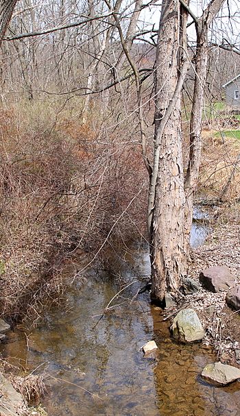
Salem Creek from Stone Church Road
|
|
| Other name(s) | Stone Church Hollow Creek, Seyberts Creek, Varners Creek |
| Physical characteristics | |
| Main source | southern edge of Lee Mountain in Salem Township, Luzerne County, Pennsylvania between 920 and 940 feet (280 and 290 m) |
| River mouth | Susquehanna River in Salem Township, Luzerne County, Pennsylvania 489 ft (149 m) 41°03′50″N 76°11′34″W / 41.0639°N 76.1928°W |
| Length | 4.8 mi (7.7 km) |
| Basin features | |
| Progression | Susquehanna River → Chesapeake Bay |
| Basin size | 3.77 sq mi (9.8 km2) |
| Tributaries |
|
Salem Creek is a cool stream in Luzerne County, Pennsylvania. It's also known by other names like Stone Church Hollow Creek, Seyberts Creek, or Varners Creek. This creek is about 4.8 miles (7.7 km) long and flows through Salem Township before joining the big Susquehanna River.
The area around Salem Creek is quite interesting! It's part of a region with lots of ridges and valleys, and it was once covered by huge glaciers. In fact, the creek helped carry away melted ice from these glaciers a long time ago. Today, you can find different types of rock formations near the creek, and it's home to some cool fish like trout. There's even a dam that was built on the creek, though it had a bit of an adventure in the 1950s!
Contents
Where Salem Creek Flows
Salem Creek starts its journey on the southern side of Lee Mountain in Salem Township. It flows west for a little while, then enters a valley and turns southwest. After a bit, the creek turns south.
It briefly turns southeast before heading south again for a few miles. Along the way, it gets water from an unnamed stream that joins it from the right side. The creek's valley then becomes much flatter. It turns south-southeast for a short distance before turning south again.
Finally, the creek enters a valley called Sybert Hollow. After flowing through this hollow, it crosses US Route 11 and soon after, it meets the Susquehanna River. This meeting point is near the border between Salem Township and Nescopeck Township. Salem Creek joins the Susquehanna River about 163.46 miles (263.06 km) upstream from where the Susquehanna itself flows into the ocean.
Salem Creek's Tributaries
Salem Creek doesn't have any named streams flowing into it, but it does have one unnamed helper stream. This unnamed stream is about 0.8 miles (1.3 km) long and joins Salem Creek after flowing past Summer Hill.
Water Flow and Floods
The amount of water flowing in Salem Creek each day is usually around 3.95 cubic feet per second. This is like saying how much water passes a certain point every second.
Sometimes, after heavy rains, the creek's water level can rise a lot. For example, there's a 10 percent chance each year that the water flow could reach 640 cubic feet per second. There's also a smaller chance (about 0.2 percent) that it could reach a huge 4300 cubic feet per second!
Even though the creek's flow is much less than it was during the Ice Age, it can still cause big floods when there's a lot of rain.
Land Around the Creek
The land near where Salem Creek meets the Susquehanna River is about 489 feet (149 m) above sea level. Where the creek starts, high up on Lee Mountain, the elevation is between 920 and 940 feet (280 and 290 m) above sea level.
In the middle part of its journey, Salem Creek flows past a steep slope of Summer Hill. North of this hill, the creek has carved a deep valley. Just before Summer Hill, the creek goes through a rocky gorge. This gorge has cool features like potholes and plunge pools, which are deep holes carved by the water. The gorge is quite deep! Towards its end, the creek drops through Sybert Hollow to reach the same level as the Susquehanna River.
You can also find a dam and a weir (a small dam) made of concrete on Salem Creek. The weir is about 1,500 feet (460 m) downstream from the dam. There's even a natural amphitheater along the creek, which is like a small, natural stage area. It's about 9 feet (2.7 m) wide, 6 feet (1.8 m) high, and 4.5 feet (1.4 m) deep.
How the Land Was Formed
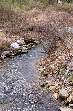
Salem Creek is located in the Ridge-and-Valley Appalachians region, which is known for its long, parallel mountains and valleys. The creek itself is a freestone stream, meaning its bed is mostly made of natural rock and gravel, not soft soil.
During the last Ice Age, called the late Wisconsinan glaciation, Salem Creek acted like a giant drain for glacial meltwater. This means it carried away tons of water from melting glaciers. The edge of these glaciers crossed the creek about 2.3 miles (3.7 km) upstream from its mouth.
In 1978, scientists found amazing signs of how the glacial meltwater shaped Salem Creek. They saw a series of potholes and plunge pools carved into the sandstone and siltstone rocks of the Trimmers Rock Formation. These potholes were huge, up to 15 feet (4.6 m) wide and 10 to 15 feet (3.0 to 4.6 m) deep! Over time, the water continued to cut down, and some of these potholes broke open.
The gorge that Salem Creek flows through is made of strong rocks from the Catskill Formation and the Trimmers Rock Formation. East of the creek, you can find boulders left behind by glaciers, called glacial till. There's also a large area of kames (hills made of sand and gravel left by glaciers) near where the creek starts.
The Creek's Surroundings
The entire area that drains into Salem Creek, called its watershed, covers about 3.77 square miles (9.8 km2). The creek is completely within the Berwick area on United States Geological Survey maps. It's located about 2 miles (3.2 km) northeast of the town of Berwick.
The very beginning of Salem Creek is in swampy land that doesn't drain well. However, a long time ago, before the last Ice Age, the creek's source was in a notch on Lee Mountain, about 0.4 miles (0.64 km) from where it starts today. That old starting point is now part of a different, shorter stream that flows east to the Susquehanna River.
History of Salem Creek
Salem Creek was officially added to the Geographic Names Information System on August 2, 1979. Its special ID number there is 1186856. As mentioned, it's also known as Stone Church Hollow Creek, especially on county maps. Other old names for it include Seyberts Creek and Varners Creek.
The Berwick Water Company (now called the Keystone Water Company) once built a dam on Salem Creek, upstream from Summer Hill. This dam was made of earth and rock and was 18 feet (5.5 m) high. In October 1954, a big rainstorm from Hurricane Hazel caused the creek to rise so much that it broke through the dam, causing it to fail.
Scientists did a special survey using electrofishing on Salem Creek on September 7, 1994, to study the fish living there.
There's a bridge that carries State Route 4037 over Salem Creek. As of 2014, there were plans to either replace or fix up this bridge.
Animals in Salem Creek
The entire area that drains into Salem Creek is special because it's designated as a Coldwater Fishery and a Migratory Fishery. This means it's a great place for fish that like cold water, and it's also important for fish that travel to different places.
Wild trout live and naturally reproduce in Salem Creek, from where it starts all the way to its mouth. You can find both brook trout and brown trout in the creek. Brook trout are more common here. The trout usually lay their eggs on gravel at the bottom of the creek.


