Salida, Colorado facts for kids
Quick facts for kids
Salida, Colorado
|
|
|---|---|

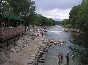
The Arkansas River Walk in downtown Salida.
|
|
| Nickname(s):
Heart of the Rockies
|
|
| Motto(s):
"Union, Justice, Safety"
|
|

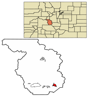
Location of the City of Salida in Chaffee County, Colorado.
|
|
| Country | |
| State | |
| County | Chaffee County |
| Founded | 1880 |
| Incorporated | March 23, 1891 |
| Government | |
| • Type | Statutory city |
| Area | |
| • Total | 2.77 sq mi (7.17 km2) |
| • Land | 2.77 sq mi (7.17 km2) |
| • Water | 0.00 sq mi (0.00 km2) |
| Elevation | 7,084 ft (2,159 m) |
| Population
(2020)
|
|
| • Total | 5,666 |
| • Density | 2,045/sq mi (790.2/km2) |
| Time zone | UTC−7 (Mountain (MST)) |
| • Summer (DST) | UTC−6 (MDT) |
| ZIP codes |
81201, 81227 (PO Box), 81237
|
| Area code(s) | 719 |
| FIPS code | 08-67280 |
| GNIS ID | 204758 |
Salida (pronounced "suh-LY-duh") is a city in Colorado, United States. Its name means "exit" in Spanish. It is the main city and the county seat of Chaffee County. In 2020, about 5,666 people lived there.
Contents
History of Salida
The first post office in the area opened on June 16, 1880. It was first called Arkansas, Colorado. On March 28, 1881, its name changed to Salida.
The name "Salida" comes from a Spanish word meaning "exit." The city got this name because it is located where the Arkansas River leaves the valley. It then flows into a place called Bighorn Sheep Canyon. The town of Salida officially became a city on March 23, 1891.
Geography and Location
Salida covers an area of about 2.77 square miles. The Arkansas River flows through the city. This river is very important for local farms, providing them with water.
Mountains Around Salida
Many mountain ranges surround Salida.
- The Sawatch Range is about 10 miles west of the city. These mountains run from north to south.
- The Mosquito Range is to the east. It runs parallel to the Sawatch Range. These two ranges create the Upper Arkansas Valley. The southern part of the Mosquito Range, near Salida, is known as the Arkansas Hills.
- Methodist Mountain is a large mountain to the south. It is the northernmost mountain in the Sangre de Cristo Mountains.
- To the north of Salida is the Upper Arkansas Valley. The town of Buena Vista is also located there.
Roads and Travel
U.S. Route 50 runs along the southern edge of Salida.
- To the east, this road goes about 58 miles to Cañon City.
- To the west, it goes 4 miles to Poncha Springs. It then continues 63 miles over the Continental Divide to Gunnison.
- Other cities to the east include Canon City and Pueblo.
Salida's Climate
Salida has a Cold semi-arid climate. This means it is generally dry, but not a desert. It also has cold winters.
| Climate data for Salida, Colorado (1991–2020 normals, extremes 1897–1923, 1931–2017) | |||||||||||||
|---|---|---|---|---|---|---|---|---|---|---|---|---|---|
| Month | Jan | Feb | Mar | Apr | May | Jun | Jul | Aug | Sep | Oct | Nov | Dec | Year |
| Record high °F (°C) | 65 (18) |
71 (22) |
77 (25) |
82 (28) |
93 (34) |
98 (37) |
103 (39) |
100 (38) |
94 (34) |
85 (29) |
80 (27) |
70 (21) |
103 (39) |
| Mean maximum °F (°C) | 57.9 (14.4) |
60.0 (15.6) |
67.7 (19.8) |
75.3 (24.1) |
83.0 (28.3) |
91.1 (32.8) |
93.9 (34.4) |
89.9 (32.2) |
85.6 (29.8) |
78.2 (25.7) |
66.9 (19.4) |
58.0 (14.4) |
94.3 (34.6) |
| Mean daily maximum °F (°C) | 43.4 (6.3) |
45.5 (7.5) |
54.0 (12.2) |
60.3 (15.7) |
70.2 (21.2) |
82.0 (27.8) |
85.8 (29.9) |
83.1 (28.4) |
77.0 (25.0) |
65.4 (18.6) |
52.7 (11.5) |
43.2 (6.2) |
63.6 (17.6) |
| Daily mean °F (°C) | 27.4 (−2.6) |
30.1 (−1.1) |
37.5 (3.1) |
44.0 (6.7) |
52.4 (11.3) |
62.7 (17.1) |
67.4 (19.7) |
65.1 (18.4) |
58.0 (14.4) |
47.1 (8.4) |
36.1 (2.3) |
27.9 (−2.3) |
46.3 (7.9) |
| Mean daily minimum °F (°C) | 11.5 (−11.4) |
14.8 (−9.6) |
21.0 (−6.1) |
27.7 (−2.4) |
34.6 (1.4) |
43.4 (6.3) |
49.1 (9.5) |
47.2 (8.4) |
38.9 (3.8) |
28.9 (−1.7) |
19.5 (−6.9) |
12.6 (−10.8) |
29.1 (−1.6) |
| Mean minimum °F (°C) | −5.1 (−20.6) |
−6.3 (−21.3) |
5.4 (−14.8) |
12.5 (−10.8) |
23.4 (−4.8) |
32.4 (0.2) |
40.6 (4.8) |
38.4 (3.6) |
26.6 (−3.0) |
14.0 (−10.0) |
1.6 (−16.9) |
−7.3 (−21.8) |
−15.7 (−26.5) |
| Record low °F (°C) | −35 (−37) |
−33 (−36) |
−21 (−29) |
−8 (−22) |
13 (−11) |
23 (−5) |
30 (−1) |
31 (−1) |
14 (−10) |
−4 (−20) |
−20 (−29) |
−31 (−35) |
−35 (−37) |
| Average precipitation inches (mm) | 0.31 (7.9) |
0.27 (6.9) |
0.69 (18) |
1.05 (27) |
0.96 (24) |
0.50 (13) |
1.36 (35) |
1.46 (37) |
0.67 (17) |
0.87 (22) |
0.25 (6.4) |
0.38 (9.7) |
8.77 (223) |
| Average snowfall inches (cm) | 4.0 (10) |
4.1 (10) |
6.5 (17) |
8.0 (20) |
2.7 (6.9) |
0.0 (0.0) |
0.0 (0.0) |
0.0 (0.0) |
0.0 (0.0) |
2.6 (6.6) |
4.1 (10) |
4.7 (12) |
36.7 (93) |
| Average precipitation days (≥ 0.01 in) | 2.3 | 2.4 | 3.9 | 4.7 | 5.0 | 4.3 | 8.3 | 9.9 | 5.1 | 4.9 | 3.1 | 3.0 | 56.9 |
| Average snowy days (≥ 0.1 in) | 2.1 | 2.2 | 2.4 | 2.6 | 0.6 | 0.0 | 0.0 | 0.0 | 0.0 | 1.1 | 2.3 | 3.0 | 16.3 |
| Source: NOAA (mean maxima/minima 1981–2010) | |||||||||||||
Population Changes Over Time
| Historical population | |||
|---|---|---|---|
| Census | Pop. | %± | |
| 1890 | 2,586 | — | |
| 1900 | 3,722 | 43.9% | |
| 1910 | 4,425 | 18.9% | |
| 1920 | 4,689 | 6.0% | |
| 1930 | 5,065 | 8.0% | |
| 1940 | 4,969 | −1.9% | |
| 1950 | 4,553 | −8.4% | |
| 1960 | 4,560 | 0.2% | |
| 1970 | 4,355 | −4.5% | |
| 1980 | 4,870 | 11.8% | |
| 1990 | 4,737 | −2.7% | |
| 2000 | 5,504 | 16.2% | |
| 2010 | 5,236 | −4.9% | |
| 2020 | 5,666 | 8.2% | |
| U.S. Decennial Census | |||
The population of Salida has changed over the years. The first official count in 1890 showed 2,586 people. The population grew steadily for many decades. In 2020, the city had 5,666 residents.
Schools and Learning
Salida has several schools for students.
- There are two public high schools: Salida High School and Horizons Exploratory Academy.
- For middle school students, there are Salida Middle School, Salida Montessori Charter School, and the Crest Academy.
- For older students, Colorado Mountain College opened a campus in Salida in 2019.
Getting Around Salida
Salida is part of Colorado's Bustang bus system. You can catch buses on the Alamosa-Pueblo and Crested Butte-Denver Outrider lines. Mountain Valley Transport also offers local bus service. They have hourly trips between Salida and Buena Vista during the day. They also offer door-to-door service within the local area.
Salida's Culture and Arts
The downtown area of Salida is very special. It was added to the National Register of Historic Places in 1984. This means it has important historical buildings.
On March 30, 2012, downtown Salida was named one of the first "Certified Creative Districts" in Colorado. This award recognizes places that are centers for arts and culture.
Salida is also home to the Shavano Chapter of the Columbine Poets of Colorado. This group is part of the National Federation of State Poetry Societies. They organize workshops and festivals. They also hold poetry contests for both adults and students.
Famous People from Salida
Some well-known people have lived in Salida:
- Sally Blane, an actress.
- Louie Croft Boyd, who was a Superintendent of Nurses at Rio Grande Hospital.
- Chris Guccione, a Major League Baseball umpire.
- Kent Haruf, a novelist who wrote books.
- Ruth Hinshaw Spray, a person who worked for peace.
See also
 In Spanish: Salida (Colorado) para niños
 | Bayard Rustin |
 | Jeannette Carter |
 | Jeremiah A. Brown |


