
Salt Island, Anglesey facts for kids
Salt Island (which is called Ynys yr Halen in Welsh) is connected to Holy Island, Anglesey, in North Wales. It helps protect the Old Harbour of Holyhead from the strong waves of the Irish Sea. Salt Island is an important part of the Port of Holyhead.
Contents
Island's Past
Salt Island got its name from a special factory that used to be there. This factory took sea water and removed the salt from it. This was a way to make sea salt!
In the early 1700s, people sometimes mixed this sea salt with rock salt. This rock salt was often brought onto the island secretly. Mixing the two kinds of salt made the factory's product even better. However, the factory stopped making salt in 1775.
Another important building that used to be on the island was the Stanley Sailor's Hospital. A kind person who wanted to help others, called a philanthropist, started this hospital in 1871. At first, it only looked after sailors. But soon, it became a hospital for everyone. The hospital became part of the National Health Service in 1948 and closed its doors in 1987.
Lighthouses of Salt Island
.jpg)
Salt Island has been home to three different lighthouses over the years. The lighthouse you can see there today is called the Holyhead Mail Pier Light.
A famous designer named John Rennie the Elder planned this lighthouse in 1821. Sadly, he passed away before he could watch it being built. This lighthouse is one of the few buildings designed by Rennie that are still standing today. The Holyhead Mail Pier Light was replaced by the Holyhead Breakwater Lighthouse when a new harbour opened in 1873.
The Piers

The main pier on Salt Island is called the Admiralty Pier. It opened in 1821. This pier stretches about 300 metres (about 984 feet) out into the sea towards the east. It has been used for ferry boats to carry passengers and goods ever since it opened.
The Admiralty Pier is very important because it connects Great Britain and Ireland. Two kings and queens have visited it!
- On August 7, 1821, King George IV arrived here from Ireland.
- In 1898, Queen Victoria sailed from here on her last trip to Ireland.
There were plans to build another pier, called an inner arm, from Salt Island. It was meant to be about 2,100 feet long. This new pier would have worked with the very long breakwater (which is 5,100 feet long and was built between 1848 and 1876). Stone blocks from the railway that carried rocks from the Holyhead Mountain quarry to build the breakwater can still be seen along Newry Beach. However, the inner arm was never finished, and only a pile of rocks remains at the northern tip of the island.
More recently, starting in February 2001, Salt Island was made bigger by adding new land to the sea. This process is called land reclamation. About 11 acres (4.5 hectares) of new land were created. This project cost £10 million and involved moving about 7,000 tonnes of rock and mud every day!
Getting Around and Access

Salt Island is a key part of the port of Holyhead. Most of the island is used as a busy terminal for passengers, cars, and freight. This is where ferry boats travel to and from Ireland. Both Irish Ferries and Stena Line sail from Salt Island to Dublin port and to Dún Laoghaire.
The Holyhead lifeboat station, which helps people in trouble at sea, is also located on the island. The Admiralty Arch is very close to the southern end of the island. This arch marks the end of the A5, a major road that connects London all the way to Holyhead. The arch opened in 1826 when the last part of the road, the Menai Suspension Bridge, was finished.
There used to be a beach on Salt Island that was open to the public. However, it was closed in 2003 and has not reopened. Because the island is a busy port, access for pedestrians is very limited and carefully controlled.
Images for kids
-
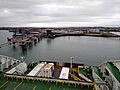
View of Salt Island from an arriving ship

See also
 In Spanish: Isla Salt para niños
