
Holyhead Mountain facts for kids
Quick facts for kids Holyhead Mountain |
|
|---|---|

Holyhead Mountain from the town's New Park
|
|
| Highest point | |
| Elevation | 220 m (720 ft) |
| Prominence | 220 m (720 ft) |
| Parent peak | none - HP Holy Island |
| Listing | Marilyn, council top |
| Geography | |

Holyhead Mountain
Location in Anglesey
|
|
| OS grid | SH218829 |
| Topo map | OS Landranger 114 |
Holyhead Mountain, called Mynydd Tŵr in Welsh, is the tallest mountain on Holy Island, Anglesey. It is also the highest point in the whole county of Anglesey, located in north Wales. This mountain sits about two miles west of the town of Holyhead. Its sides drop steeply down to the Irish Sea. On a clear day, you can even see Ireland from the top! Holyhead Mountain is also a very important place for many kinds of seabirds.
Contents
Exploring Holyhead Mountain's History and Nature
Holyhead Mountain is found on Holy Island, Anglesey, sticking out into the Irish Sea. It stands at 722 feet (220 m) (220 meters) high. This makes it the highest mountain in Anglesey county. It is even taller than Bodafon Mountain (584 feet (178 m)) on the main island.
Ancient History and Settlements
On the east side of the mountain, you can find the remains of an old Roman watchtower. This tower was called Caer y Tŵr, which means "Tower Fortress." The Welsh name for Holyhead Mountain comes from this ancient tower.
Near the bottom of Holyhead Mountain, there's also an Iron Age stone circle settlement. This area shows signs of being lived in a very long time ago. People lived here during the middle part of the Stone Age, the Neolithic Age, the Bronze Age, and the Iron Age. You can still see traces of old farm fields. There are also bases of twenty dry-stone huts. Several standing stones are also nearby.
Mountain Landscape and Quarrying
The very top of Holyhead Mountain is rocky. The slopes below are covered in beautiful heather plants. A lot of the rock from this mountain was used to build the Holyhead Breakwater. This breakwater is a long wall that protects the port of Holyhead. About seven million tons of limestone were taken from the mountain's quarries. This rock helped create the longest breakwater in Britain, which is almost one and a half miles (2.4 km) long.
You can also find the remains of an old brick factory on the mountain. This factory closed in 1973. Special bricks made here were also used when the breakwater was built.
Views and Wildlife
Holyhead Mountain is a popular spot for many visitors. It is also very close to the South Stack lighthouse. Lots of people come to see the many different birds that nest along the cliffs near South Stack.
From the top of the mountain, you can see far and wide. The views are especially amazing towards the west. On clear days, you can often see the Wicklow Mountains in Ireland across the Irish Sea. Many birds make their homes here. These include Atlantic puffins, stonechats, and Eurasian oystercatchers. If you are lucky, you might even spot grey seals swimming offshore during the summer months.
Gallery


Images for kids
-
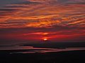
Sunset over the mountain.
-
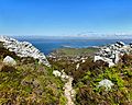
Main entrance to the Celtic fort.
,_Wales15.jpg)
