South Stack facts for kids
|
Ynys Lawd
|
|
|---|---|

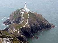
South Stack Lighthouse on South Stack
|
|
| Geography | |
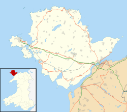
| Location | Irish Sea near Holyhead, Anglesey |
| Coordinates | 53°18′24.40″N 4°41′56.91″W / 53.3067778°N 4.6991417°W |
| Length | 0.15 mi (0.24 km) |
| Width | 0.1 mi (0.2 km) |
| Highest point | 134 ft (41 m) |
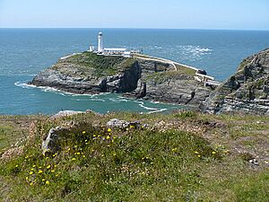
South Stack (which in Welsh is called Ynys Lawd) is a small island. It is located just off Holy Island on the northwest coast of Anglesey, Wales.
Contents
How South Stack Was Formed

South Stack is a special type of island called a sea stack. It was created by the power of ocean waves. These waves slowly wore away the sedimentary rocks that once connected the island to the mainland.
Understanding the Rocks at South Stack
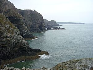
The rocks in this area are part of what geologists call the South Stack Formation. Here, you can see layers of sandstone and shale. These layers have been twisted and bent into large folds. You can see these folds clearly in the seacliffs. The best place to view them is from the steps that lead down to the lighthouse.
Above these folded rocks are thick layers of pure Holyhead Quartzite. This hard rock makes up most of Holyhead Mountain. Scientists are still studying how these rocks got their unique look. Some think it was caused by huge movements of the Earth.
South Stack's Geological Importance
The amazing geology of South Stack is very important. The Geological Society of London has chosen it as one of the top 100 geological sites in the United Kingdom. This is because it shows such clear examples of small-scale rock folding.
The Famous South Stack Lighthouse

The South Stack Lighthouse was finished in 1809. It stands 41 m (135 ft) above the sea on South Stack island. The light tower itself is 28 m (92 ft) tall. The entire lighthouse area covers about seven acres (2.8 ha). To reach the lighthouse, visitors must go down over 390 stone steps and 10 metal steps to a footbridge.
Crossing to the Lighthouse
When the lighthouse was first built, the only way to get to the island was in a basket. This basket hung from a rope! In 1828, an iron suspension bridge was built to make crossing easier. This bridge was replaced in 1964 with a steel cable bridge.
However, in 1983, the bridge had to close because it was not safe. A new bridge, made of strong aluminum, was built. The lighthouse then reopened to the public in 1997. Today, it is a very popular place. Thousands of people visit it every year.
South Stack Nature Reserve
The cliffs around South Stack are part of the South Stack Cliffs RSPB reserve. This reserve is home to about 8,000 birds that nest there during breeding season. The RSPB has a visitor center with a bird hide at Elin's Tower on the mainland.
Wildlife at South Stack
From the visitor center, you can see many types of birds and marine animals. Birds include choughs, peregrine falcons, and kestrels. In the water, you might spot harbour porpoises, grey seals, Risso's dolphins, and bottlenose dolphins.
Tidal Energy Project Plans
In 2019, there were plans for a large tidal energy project near South Stack. This project would cover 35 km2 (14 sq mi) of the sea. Some people are worried about how this project might affect the beautiful views. They are also concerned about its impact on tourism, fishing, and the local wildlife.
Developers have said that seabirds and marine mammals could be affected. This includes bottlenose dolphins and harbour porpoises. Bird species like razorbills and common guillemots could also be severely impacted. The RSPB is especially worried that the razorbill colony at South Stack might be wiped out.
Walking Trails Around South Stack
South Stack is part of the Anglesey Coastal Path. This is a 200-kilometre (124 mi) long walking trail that goes all around the island of Anglesey.
The Cybi Circular Walk
The Cybi Circular Walk goes around Holyhead Mountain. You can choose a long or a short version of this walk. The short walk is four miles (6.4 km) long and takes about two hours to finish. Along the way, starting from Breakwater Country Park, you can see other interesting places. These include the North Stack Fog Signal station, Caer y Tŵr, and Tŷ Mawr Hut Circles.
South Stack in Media
The stunning natural beauty of South Stack has been featured in photos and books.
Music and Books
The cover photo for Roxy Music's album Siren was taken at South Stack. It was shot in August 1975, right below the middle part of the bridge. In 2010, a French comic book called Les Gardiens des Enfers ("The Guardians of Hell") was published. The story mostly takes place at South Stack lighthouse in 1859. You can see the cover and first pages on the publisher's website.
 | Sharif Bey |
 | Hale Woodruff |
 | Richmond Barthé |
 | Purvis Young |


