
Sandia Crest facts for kids
Quick facts for kids Sandia Crest |
|
|---|---|

Closeup of Sandia Crest from the west
|
|
| Highest point | |
| Elevation | 10,679 ft (3,255 m) |
| Prominence | 4,098 ft (1,249 m) |
| Dimensions | |
| Length | 5 mi (8 km) N-S |
| Naming | |
| Etymology | Watermelon (Spanish) |
| Nickname | Sandia Peak, the Crest |
| Native name | Posu gai hoo-oo (Southern Tiwa) |
| English translation | "Where water slides down arroyo" |
| Defining authority | Sandia Pueblo |
| Geography | |
| Country | United States |
| State | New Mexico |
| County | Bernalillo |
| Nearest City | Albuquerque |
| Parent range | Sandia-Manzano Mountains |
| Biome | Hudsonian Zone |
| Geology | |
| Formed by | Rio Grande Rift |
| Orogeny | Laramidian |
| Age of rock | 300 Ma |
| Mountain type | Tilted fault-block |
| Type of rock | Sedimentary |
| Climbing | |
| Easiest route | Grand Enchantment Trail |
| Normal route | La Luz Trail |
| Access | Albuquerque, Sandia Pueblo |
Sandia Crest, also known as Sandia Peak, is the highest point of the Sandia Mountains in New Mexico, United States. Instead of a sharp peak, it's a long mountain ridge. From the west, the land drops sharply over 4,000 feet (1,200 m) to the city of Albuquerque below. This area is part of the Cibola National Forest. The Crest has a popular viewing area, a gift shop, and is home to the Sandia Peak Ski Area and the Sandia Peak Tramway.
Contents
What's in a Name? The Sandia Story
Sandia Crest gets its name from the Sandia Mountains. Sandía means "watermelon" in Spanish. Many people believe the mountains look like a watermelon because they turn reddish at sunset. Also, from the west, the green trees near the top can look like the "rind" of a watermelon.
However, the Sandia Pueblo people have another idea. They believe that when the Spanish arrived in 1540, they saw squash growing there. The Spanish thought it was watermelon, and the name "Sandia" stuck to the mountains.
The name "Sandia Peak" became popular thanks to Robert Nordhaus. He started a ski area in the mountains in 1936. In 1962, he put in the first chairlift to the Crest. He then renamed the ski resort to Sandia Peak Ski Area. When he opened the famous tramway in 1966, it also took the name "Sandia Peak."
Exploring Sandia Crest

Sandia Crest is a long, high ridge covered mostly with spruce and fir trees. You can also see many radio and television antennas at the top.
At the end of Sandia Crest Road (NM 536), there's a special viewing area called the Sandia Crest House. It has a gift shop, a cafe, a visitor center, and restrooms. You can enjoy amazing views from here.
At the southern end of the Crest is the Sandia Peak Ski Area. Here, you'll find a restaurant called TEN 3. Its name comes from its elevation, "ten-three" (10,300 feet). Chairlifts take skiers and visitors up the mountain.
The Sandia Peak Tramway is also here. It takes people on a 15-minute ride from the edge of Albuquerque up to Sandia Peak. It's the longest aerial tramway in the Americas! From 1966 to 2010, it was the longest in the world.
Hikers love the Kiwanis Cabin ruins, which are located between the Crest House and the ski resort. The La Luz Trail connects the Crest to the city below. The Grand Enchantment Trail also crosses the Crest.
A Look Back in Time: History of the Crest
In 1819, the governor of Santa Fe established a land grant that used Sandia Crest as its western border.
In 1927, the US Forest Service built a dirt road to Sandia Crest. This road was paved in 1960 to make it easier to reach the ski area. Before paving, it was a long, bumpy ride. The new road made it a quick 45-minute drive.

In 1930, the Kiwanis Group of the Civilian Conservation Corps built a stone cabin on the Crest. It was built in the traditional Pueblo style. Today, the ruins of this cabin are a popular spot for hikers.
In 1964, Robert Nordhaus, inspired by trams he saw in Europe, decided to build an aerial tramway from Albuquerque to the Crest. A Swiss company designed and built it. Construction took two years and needed over 5,000 helicopter trips to carry materials. The tramway opened on May 7, 1966.
In 2006, Albuquerque celebrated its 300th birthday. They put a display of 300 bright LED lights on top of the Crest. These lights stayed there for 18 months.
In 2017, the US Forest Service approved plans for a "Four Seasons Activity Area" at the Crest. This will include a food service building, two ziplines, and a mountain coaster. The mountain coaster will be the first in New Mexico. It will offer more fun activities all year round.
How the Mountains Formed: Geology

The Sandia Mountains are a type of mountain called a fault block range. They are located on the eastern edge of the Rio Grande Rift Valley. The Sandias were lifted up over the last ten million years as the Rio Grande Rift formed. They create the eastern boundary of the Albuquerque Basin.
You can easily see how the mountains tilted from the Crest. It slopes gently down to the east but drops very sharply to the west. The Crest is mostly made of limestone on top of older Sandia Granite. This granite is about 300 million years old.
Plants and Animals: Ecology
Sandia Crest is part of the Cibola National Forest. The forest here is called a Hudsonian Life Zone coniferous forest. This means it's mostly made up of cone-bearing trees. You'll find trees like Engelmann spruce, white fir, and ponderosa pine on the Crest.
Many animals live on the Crest. You might see elk, mule deer, New Mexico black bears, raccoons, ring-tail cats, and bobcats. Different kinds of squirrels also live here. For birds, there are bald eagles, Steller's Jays, pinyon jays, various finches, and canyon wrens.
Climbing Adventures
Sandia Crest is a very popular place for rock climbing. Some well-known climbing spots include the Shield, the Needle, and the Thumb.
35°12′36.41″N 106°26′55.14″W / 35.2101139°N 106.4486500°W
Images for kids
-
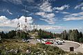
Part of the parking lot to the viewing area and radio transmitters on Sandia Crest, September 2008
-
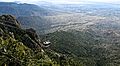
View from Sandia Crest on the city of Albuquerque and Sandia Peak Tramway
-
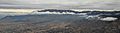
Sandia Crest above the clouds with Albuquerque in the foreground in 2018

