
Sceale Bay, South Australia facts for kids
Quick facts for kids Sceale BaySouth Australia |
|||||||||||||||
|---|---|---|---|---|---|---|---|---|---|---|---|---|---|---|---|

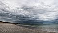
Sceale Bay viewed from Sceale Bay Conservation Park
|
|||||||||||||||

Sceale Bay
Location in South Australia
|
|||||||||||||||
| Population | 42 (2016 census) | ||||||||||||||
| Established | 25 October 1888 (town) 12 April 2001 (locality) |
||||||||||||||
| Postcode(s) | 5680 | ||||||||||||||
| Elevation | 1 m (3 ft) | ||||||||||||||
| Time zone | ACST (UTC+9:30) | ||||||||||||||
| • Summer (DST) | ACST (UTC+10:30) | ||||||||||||||
| LGA(s) | District Council of Streaky Bay | ||||||||||||||
| Region | Eyre Western | ||||||||||||||
| County | Robinson | ||||||||||||||
| State electorate(s) | Flinders | ||||||||||||||
| Federal Division(s) | Grey | ||||||||||||||
|
|||||||||||||||
|
|||||||||||||||
| Footnotes | Adjoining localities | ||||||||||||||
Sceale Bay (pronounced "Scale Bay"), once known as Yanera, is a small town located in South Australia. It is about 32 kilometers south of Streaky Bay on the Eyre Peninsula. Even though only a few people live there all year, the town gets much busier during the summer holidays. Sceale Bay is mostly a quiet place for vacations, with no big businesses or factories.
In August 2016, a count of the population showed that 42 people lived in Sceale Bay.
Contents
Exploring Sceale Bay's Location
The town of Sceale Bay sits right on the edge of a bay that shares its name. The water in the bay is usually calm, with long, sandy beaches that are great for relaxing. However, the coast outside the bay faces the strong waves of the Southern Ocean. Along this coast, you can find tall cliffs and interesting rock shapes. Away from the coast, the land is mostly used for farming.
A Look at Sceale Bay's Past
The bay was given its name, Sceale Bay, in 1858 by Captain Bloomfield Douglas. He was part of the South Australian Marine Board.
The town itself was officially started on October 25, 1888, and was first called Yanera. Later, in 1940, its name was changed to Sceale Bay. A jetty (a long pier) was built in 1910 to help traders who traveled along the coast. Even though people tried hard to save it, the jetty was taken down in 1972.
The area around the town, called the locality, was officially created on April 12, 2001. Its borders were changed a bit on July 21, 2017. This change was made to include a piece of land from the nearby area of Yanerbie within Sceale Bay.
Fun Things to Do in Sceale Bay
Sceale Bay is a small place, so it does not get a huge number of tourists. This is partly because there are not many places to stay. In the past, there was a caravan park and a small shop that sold petrol, food, and fishing gear, but these are now closed.
Fishing Adventures
Fishing is the most popular activity here. You can fish from a boat, from the rocks, or right from the beach.
- All year round, you can catch fish like Snapper, Trevally, Nannygai, Whiting, and Kingfish in the deeper parts of the ocean.
- In the summer, large Bluefin Tuna gather offshore.
- In the calmer waters of the bay, you can catch Whiting, Tommy Ruff, and Salmon.
There is also a boat ramp in Sceale Bay, making it easy to launch your boat.
Nearby Attractions
- Murphy's Haystacks: These unique rock formations are about a 15-minute drive from Sceale Bay. They are a popular sight to see.
Protecting Nature: Conservation Parks
There are several protected areas close to Sceale Bay that help keep nature safe:
- Cape Blanche Conservation Park and Nicolas Baudin Island Conservation Park are to the west.
- Searcy Bay Conservation Park is to the east.
- Sceale Bay Conservation Park is to the north. This park was created in 2006 to protect local flora (plants) and fauna (animals), especially the seal colony that lives in the bay.
Images for kids
-
A storm approaching Sceale Bay.

