Scofield, Utah facts for kids
Quick facts for kids
Scofield, Utah
|
|
|---|---|
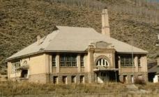
Historic Scofield Utah School building
|
|
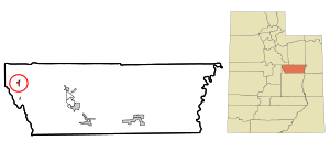
Location in Carbon County and the state of Utah
|
|
Location of Utah in the United States
|
|
| Country | |
| State | |
| County | Carbon |
| Founded | 1879 |
| Named for | Mathew B. Scofield |
| Area | |
| • Total | 0.92 sq mi (2.39 km2) |
| • Land | 0.92 sq mi (2.39 km2) |
| • Water | 0.00 sq mi (0.00 km2) |
| Elevation | 7,733 ft (2,357 m) |
| Population
(2020)
|
|
| • Total | 26 |
| • Density | 24.95/sq mi (9.64/km2) |
| Time zone | UTC-7 (Mountain (MST)) |
| • Summer (DST) | UTC-6 (MDT) |
| ZIP code |
84526
|
| Area code(s) | 435 |
| FIPS code | 49-67990 |
| GNIS feature ID | 2413267 |
Scofield is a small town in Carbon County, Utah, United States. In 2020, only 26 people lived there. The town is named after Mathew B. Scofield. It is the smallest town in Utah based on how many people live there. Scofield is also known for a big mine disaster that happened in 1900.
Contents
History of Scofield
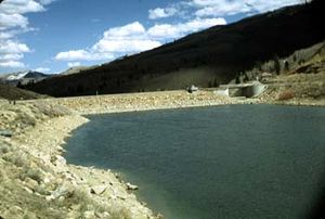
The town of Scofield is located on high ground. It is about two miles south of the Scofield Reservoir. This reservoir is the oldest and largest of the big water storage areas on the Wasatch Plateau. Scofield used to be the biggest town in Carbon County. Now, only a few people live there all the time. Some outsiders have built summer homes, which has helped the town a little.
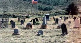
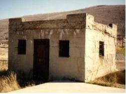
The old brick school building in town is empty. Many other buildings that were once part of the business area are now abandoned. The cemetery on a nearby hill is a reminder that this was once a much larger community.
Early Settlement and Ranching
This valley was first used as a place for large groups of cattle to graze. This was because of the many native grasses that grew well here. Some of the first people to settle in this area were S. J. Harkness and T. H. Thomas. They came because the land was perfect for their cattle.
Coal Discovery and Railroad Arrival
Coal was found in the valley in 1875. Two years later, a small mine opened. The coal was taken out using narrow roads. In the winter of 1877, heavy snow trapped the miners. They were stuck until February. This experience led them to call their camp "Winter Quarters". It became one of the first commercial coal mines in Utah.
Many of the first miners at Winter Quarters were Mormon converts. They came from coal mining areas in Wales, England, and Scotland. David Williams, a mine manager and local church leader, leased the Winter Quarters Mine.
When the Rio Grande Western Railway bought the coal company, they started a new mine. This new mine was on Mud Creek, a mile from Winter Quarters. Bishop Williams, who controlled the Mormon miners, protested this new mine. So, the Pleasant Valley Coal Company brought in workers from China. Soon, many Finns, Italians, Greeks, and other Scandinavian workers also came.
As more coal was found, it seemed like there was an endless supply. Railroad companies realized how much coal was there. They started looking for ways to build train tracks to the coal fields. The route through Spanish Fork Canyon was chosen. A narrow-gauge railroad was built into Scofield. The winter came early, and the last few miles of track were laid on ice and snow.
The Union Pacific Coal Company owned all the land where the town was built. People who wanted to build homes had to lease the land from this company. The miners did not build fancy homes. They knew they might have to leave if the work stopped. Log cabins were common because other building materials were too expensive. The Union Pacific continued to collect rent for the land.
However, this situation did not last forever. People started to question the company's right to own the land. It turned out the company did not have a perfect legal claim to the townsite. The business area grew to be over a mile long. It had many stone buildings, including an Odd Fellows Hall.
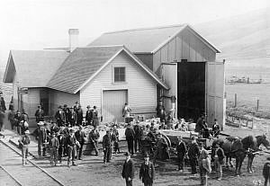
As the mine and town grew, new ways were found to move the coal. The Utah & Pleasant Valley Railroad was built. It ran from Springville to Winter Quarters and Scofield. It connected with the Denver & Rio Grande line in Colton, about 18 miles away.
In 1882, the Utah Fuel Company took over the mine and town. This company became part of the Denver & Rio Grande Railroad. The area kept growing until 1900. There were hundreds of men in the mines. The town had as many as 1,800 residents. The mine was thought to be very safe. Reports said it did not have the dangerous gases found in other coal mines.
The 1900 Mine Disaster
On May 1, 1900, a spark caused an explosion in the Winter Quarters #4 mine. The mine exploded with great force. One hundred men died instantly. Another 99 men died from the poisonous gas that followed. This made it one of the worst coal mine disasters in history. Death came so fast that some miners were found still holding their tools.
This event left 105 women without husbands and 270 children without fathers. Nearly 150 of the miners who died were buried in the cemetery in Scofield. Two special funeral trains carried the other victims to burial places in Utah and other states.
Decline of the Town
Just four weeks after the disaster, on May 28, coal mining started again at Winter Quarters. Some miners left the area for other jobs. But many others returned to the mines. New workers replaced those who died. However, coal production was affected because many experienced miners were lost. The Winter Quarters mines kept working until the 1930s, even though they were not making as much money.
During World War II, the coal processing plant and other large buildings were taken apart. Their materials were reused. The chapel and boarding house were also torn down.
In 1915, Scofield was still the largest town in Carbon County. Its citizens tried to move the county government offices to Scofield from Price. But by the 1920s, the coal industry in Pleasant Valley was clearly shrinking. Most mines stopped working. This caused the town to lose almost all its residents.
Geography and Location
Scofield is in the coal-rich area of Carbon County, Utah. It is about 19 miles from the main railroad line. The town is surrounded by hills in the upper part of Pleasant Valley. Scofield is located along Mud Creek. This is just south of the Scofield Reservoir. The water from the reservoir flows into the Price River. The Price River then flows to the Green River, which is part of the Colorado River basin.
The United States Census Bureau says that Scofield covers about 0.92 square miles (2.39 square kilometers). All of this area is land.
Utah State Route 96 goes through Scofield. This road leads north and then east for 17 miles to U.S. Route 6 near Colton. It also goes south for 6 miles to its end at Clear Creek.
Climate in Scofield
Scofield has a cold, snowy climate, like a subarctic region. It gets a lot of snow in its long, cold winters. This is because it is located in the Wasatch Range mountains. Summers are nice, with warm days and cool nights. The temperature at night stays just above freezing.
| Climate data for Scofield, Utah (Skyline Mine), 1991–2020 normals, extremes 1893–present | |||||||||||||
|---|---|---|---|---|---|---|---|---|---|---|---|---|---|
| Month | Jan | Feb | Mar | Apr | May | Jun | Jul | Aug | Sep | Oct | Nov | Dec | Year |
| Record high °F (°C) | 56 (13) |
56 (13) |
67 (19) |
74 (23) |
88 (31) |
91 (33) |
98 (37) |
94 (34) |
84 (29) |
75 (24) |
67 (19) |
59 (15) |
98 (37) |
| Mean maximum °F (°C) | 45.8 (7.7) |
46.0 (7.8) |
53.3 (11.8) |
62.0 (16.7) |
71.3 (21.8) |
79.9 (26.6) |
84.0 (28.9) |
81.5 (27.5) |
76.9 (24.9) |
67.4 (19.7) |
55.7 (13.2) |
46.4 (8.0) |
84.6 (29.2) |
| Mean daily maximum °F (°C) | 30.4 (−0.9) |
30.9 (−0.6) |
37.7 (3.2) |
43.7 (6.5) |
54.4 (12.4) |
66.4 (19.1) |
73.9 (23.3) |
71.7 (22.1) |
63.2 (17.3) |
50.1 (10.1) |
37.7 (3.2) |
29.8 (−1.2) |
49.2 (9.5) |
| Daily mean °F (°C) | 21.8 (−5.7) |
22.5 (−5.3) |
28.6 (−1.9) |
34.1 (1.2) |
43.5 (6.4) |
53.4 (11.9) |
60.8 (16.0) |
59.0 (15.0) |
51.0 (10.6) |
39.7 (4.3) |
28.5 (−1.9) |
21.1 (−6.1) |
38.7 (3.7) |
| Mean daily minimum °F (°C) | 13.1 (−10.5) |
14.0 (−10.0) |
19.5 (−6.9) |
24.4 (−4.2) |
32.6 (0.3) |
40.5 (4.7) |
47.8 (8.8) |
46.4 (8.0) |
38.8 (3.8) |
29.3 (−1.5) |
19.3 (−7.1) |
12.4 (−10.9) |
28.2 (−2.1) |
| Mean minimum °F (°C) | −5.1 (−20.6) |
−4.7 (−20.4) |
3.1 (−16.1) |
9.8 (−12.3) |
18.4 (−7.6) |
27.4 (−2.6) |
38.6 (3.7) |
37.3 (2.9) |
24.7 (−4.1) |
13.5 (−10.3) |
−0.4 (−18.0) |
−6.4 (−21.3) |
−10.4 (−23.6) |
| Record low °F (°C) | −41 (−41) |
−38 (−39) |
−27 (−33) |
−12 (−24) |
9 (−13) |
14 (−10) |
24 (−4) |
22 (−6) |
12 (−11) |
−9 (−23) |
−25 (−32) |
−37 (−38) |
−41 (−41) |
| Average precipitation inches (mm) | 3.03 (77) |
2.73 (69) |
2.43 (62) |
2.66 (68) |
1.93 (49) |
1.05 (27) |
1.48 (38) |
1.62 (41) |
1.89 (48) |
1.94 (49) |
2.31 (59) |
2.91 (74) |
25.98 (661) |
| Average snowfall inches (cm) | 42.5 (108) |
40.7 (103) |
29.6 (75) |
24.5 (62) |
7.2 (18) |
0.5 (1.3) |
0.0 (0.0) |
0.1 (0.25) |
0.6 (1.5) |
8.0 (20) |
28.9 (73) |
42.8 (109) |
225.4 (571.05) |
| Average extreme snow depth inches (cm) | 30.7 (78) |
28.5 (72) |
20.0 (51) |
9.3 (24) |
3.7 (9.4) |
0.4 (1.0) |
0.0 (0.0) |
0.0 (0.0) |
0.4 (1.0) |
4.7 (12) |
15.1 (38) |
23.8 (60) |
35.9 (91) |
| Average precipitation days (≥ 0.01 in) | 11.9 | 11.8 | 10.0 | 10.7 | 9.6 | 6.1 | 8.1 | 10.1 | 8.2 | 8.3 | 9.2 | 10.9 | 114.9 |
| Average snowy days (≥ 0.1 in) | 11.5 | 11.2 | 8.8 | 7.7 | 2.3 | 0.3 | 0.0 | 0.0 | 0.3 | 3.1 | 7.9 | 10.4 | 63.5 |
| Source 1: NOAA | |||||||||||||
| Source 2: National Weather Service | |||||||||||||
Population of Scofield
| Historical population | |||
|---|---|---|---|
| Census | Pop. | %± | |
| 1890 | 680 | — | |
| 1900 | 642 | −5.6% | |
| 1910 | 746 | 16.2% | |
| 1920 | 678 | −9.1% | |
| 1930 | 295 | −56.5% | |
| 1940 | 262 | −11.2% | |
| 1950 | 236 | −9.9% | |
| 1960 | 158 | −33.1% | |
| 1970 | 71 | −55.1% | |
| 1980 | 105 | 47.9% | |
| 1990 | 43 | −59.0% | |
| 2000 | 28 | −34.9% | |
| 2010 | 22 | −21.4% | |
| 2020 | 26 | 18.2% | |
| U.S. Decennial Census | |||
In 2000, there were 28 people living in Scofield. These people lived in 12 households, with 9 of them being families. The population was 100% White.
About 14.3% of the people were under 18 years old. The average age in the town was 45 years. The average income for a household was $26,250.
Scofield State Park
Scofield State Park is around the Scofield Reservoir. It has three camping areas: Mountain View, Madsen Bay, and Lake Side.
- Mountain View has 34 campsites. It offers restrooms, hot showers, and places to clean fish. There is also a group area and a boat ramp. You can rent boats here too.
- Madsen Bay has 40 campsites. It also has restrooms, fish cleaning areas, and a boat ramp. There is parking for day visitors.
- Lake Side is only for day use, meaning no camping. It has restrooms, a group area, and a fishing platform for people with disabilities.
Clear Creek Camp
Clear Creek Camp is an outdoor education center. It is located about 2 miles south of Scofield. This camp is for students in the Alpine School District who are older than fifth grade. Each summer, about 1,100 students visit Clear Creek Camp.
The camp helps students learn about the outdoors. It also helps them appreciate nature and its beauty. The camp started as an outdoor education program in the 1940s. It grew over the years, and a summer camp was requested. It was held in different places, including the town of Clear Creek, which is where it gets its name.
In 1973, the Alpine School District got land from Questar. This land had six cabins and a main building. The facilities were ready for students in 1974. The Alpine School District has used these same grounds ever since.
See also
 In Spanish: Scofield (Utah) para niños
 | James Van Der Zee |
 | Alma Thomas |
 | Ellis Wilson |
 | Margaret Taylor-Burroughs |


