Searsburg, Vermont facts for kids
Quick facts for kids
Searsburg, Vermont
|
|
|---|---|

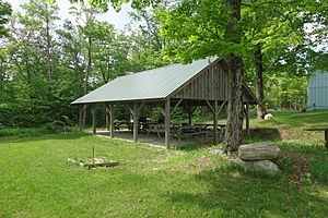
Picnic shelter
|
|

Searsburg, Vermont
|
|
| Country | United States |
| State | Vermont |
| County | Bennington |
| Area | |
| • Total | 21.6 sq mi (55.9 km2) |
| • Land | 21.4 sq mi (55.5 km2) |
| • Water | 0.1 sq mi (0.3 km2) |
| Elevation | 2,198 ft (670 m) |
| Population
(2020)
|
|
| • Total | 126 |
| • Density | 6/sq mi (2.3/km2) |
| Time zone | UTC-5 (Eastern (EST)) |
| • Summer (DST) | UTC-4 (EDT) |
| ZIP code |
05363
|
| Area code | 802 |
| FIPS code | 50-63175 |
| GNIS feature ID | 1462202 |
Searsburg is a small town located in Bennington County, Vermont, United States. In 2020, about 126 people lived there. It is known for its beautiful natural surroundings and its efforts in renewable energy.
Contents
Energy Development in Searsburg
Searsburg is home to a special wind turbine farm. This farm helps create electricity using wind power. It has 11 tall towers that stand on a ridgeline. This project is owned by Green Mountain Power.
Wind Power Research
The wind farm is not just for making electricity. It is also a place for learning and research. Scientists study how wind power works in cold places like the northeastern U.S. This helps them make wind energy even better.
Future Wind Projects
There are plans for a new wind project near the current one. A company called Iberdrola Renewables wants to build 15 more wind turbines. These would be located in Searsburg and a nearby town called Readsboro.
Geography of Searsburg
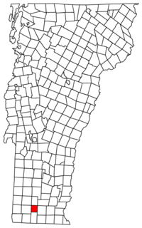
Searsburg is found in the southeastern part of Bennington County. It is nestled within the beautiful Green Mountains of Vermont. To the north and east, it shares a border with Windham County.
Roads and Rivers
A main road, Vermont Route 9, runs through the town. This road is also known as the Molly Stark Trail. If you travel east on this highway, you will reach Brattleboro in about 24 miles. Going west for about 15 miles will take you to Bennington.
The town covers about 55.9 square kilometers (21.6 square miles). Most of this area is land, with a small part being water. The Deerfield River flows through Searsburg. This river eventually joins the Connecticut River.
Population Over Time
| Historical population | |||
|---|---|---|---|
| Census | Pop. | %± | |
| 1820 | 9 | — | |
| 1830 | 40 | 344.4% | |
| 1840 | 120 | 200.0% | |
| 1850 | 201 | 67.5% | |
| 1860 | 262 | 30.3% | |
| 1870 | 235 | −10.3% | |
| 1880 | 232 | −1.3% | |
| 1890 | 173 | −25.4% | |
| 1900 | 161 | −6.9% | |
| 1910 | 142 | −11.8% | |
| 1920 | 133 | −6.3% | |
| 1930 | 103 | −22.6% | |
| 1940 | 135 | 31.1% | |
| 1950 | 84 | −37.8% | |
| 1960 | 73 | −13.1% | |
| 1970 | 84 | 15.1% | |
| 1980 | 72 | −14.3% | |
| 1990 | 85 | 18.1% | |
| 2000 | 96 | 12.9% | |
| 2010 | 109 | 13.5% | |
| 2020 | 126 | 15.6% | |
| U.S. Decennial Census | |||
Searsburg has always been a small town. Its population has changed over many years. For example, in 1820, only 9 people lived there. By 2020, the population had grown to 126 people.
Life in Searsburg
In 2000, there were 96 people living in Searsburg. The town had 40 households. About 32.5% of these households had children under 18 living with them. The average household had about 2.4 people.
The median age in Searsburg in 2000 was 42 years old. This means half the people were younger than 42 and half were older.
Voting History
Searsburg has a unique voting history in presidential elections. Sometimes, the town's votes stand out compared to the rest of Vermont.
- In 1992, Searsburg was one of only four towns in Vermont to support H. Ross Perot. He was a Reform Party candidate.
- In 2000, a Libertarian candidate named Harry Browne won in Searsburg. He received 51% of the votes. This was very unusual because he received less than half a percent of votes in the entire state.
- In 2008, Searsburg was one of only three towns in Vermont to vote for John McCain. He was the Republican candidate. Most of Vermont voted for Barack Obama that year.
See also
 In Spanish: Searsburg para niños
 | William M. Jackson |
 | Juan E. Gilbert |
 | Neil deGrasse Tyson |


