Selma, California facts for kids
Quick facts for kids
Selma, California
|
|||
|---|---|---|---|
| City of Selma | |||

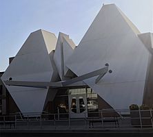
Selma Arts Center
|
|||
|
|||
| Motto(s):
"Raisin Capital Of The World"
|
|||

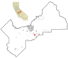
Location in Fresno County and the state of California
|
|||
| Country | United States | ||
| State | California | ||
| County | Fresno | ||
| Incorporated | March 15, 1893 | ||
| Area | |||
| • Total | 5.77 sq mi (14.94 km2) | ||
| • Land | 5.77 sq mi (14.94 km2) | ||
| • Water | 0.00 sq mi (0.00 km2) 0% | ||
| Elevation | 308 ft (94 m) | ||
| Population
(2020)
|
|||
| • Total | 24,674 | ||
| • Density | 4,276/sq mi (1,651.5/km2) | ||
| Time zone | UTC-8 (PST) | ||
| • Summer (DST) | UTC-7 (PDT) | ||
| ZIP code |
93662
|
||
| Area code(s) | 559 | ||
| FIPS code | 06-70882 | ||
| GNIS feature IDs | 1659624, 2411863 | ||
Selma is a city located in Fresno County, California. It's a growing community, with a population of 24,674 people recorded in the 2020 census. This was an increase from 23,319 people in 2010 and 19,240 in 2000. Selma is about 16 miles (26 km) southeast of Fresno, sitting at an elevation of 308 feet (94 meters) above sea level.
Contents
Geography of Selma
Selma is a city that covers an area of about 5.136 square miles (13.30 km²). All of this area is land, meaning there are no large lakes or rivers within the city limits.
Selma's Population and People
| Historical population | |||
|---|---|---|---|
| Census | Pop. | %± | |
| 1890 | 1,150 | — | |
| 1900 | 1,083 | −5.8% | |
| 1910 | 1,750 | 61.6% | |
| 1920 | 3,158 | 80.5% | |
| 1930 | 3,047 | −3.5% | |
| 1940 | 3,667 | 20.3% | |
| 1950 | 5,964 | 62.6% | |
| 1960 | 6,934 | 16.3% | |
| 1970 | 7,459 | 7.6% | |
| 1980 | 10,942 | 46.7% | |
| 1990 | 14,757 | 34.9% | |
| 2000 | 19,444 | 31.8% | |
| 2010 | 23,219 | 19.4% | |
| 2019 (est.) | 24,825 | 6.9% | |
| U.S. Decennial Census | |||
Population in 2010
In 2010, Selma had a population of 23,219 people. The city was quite busy, with about 4,521 people living per square mile (1,746 per km²).
Most of the people in Selma were White (55.4%). There were also people of other backgrounds, including African American (1.2%), Native American (2.1%), and Asian (4.6%). A large part of the population, 77.6%, identified as Hispanic or Latino.
Most people (99.3%) lived in homes with their families or housemates. The average household had about 3.59 people. Many households (53.2%) included children under 18. The average family size was 3.89 people.
The age of people in Selma varied. About 32.1% were under 18 years old. Around 11.5% were young adults aged 18 to 24. The median age in Selma was 29.5 years.
Population in 2000
In 2000, Selma's population was 19,444. The population density was about 4,476 people per square mile (1,728 per km²).
The racial makeup was 43.90% White, 0.75% African American, 1.56% Native American, and 3.18% Asian. A significant portion, 71.75%, were Hispanic or Latino.
About 45.9% of households had children under 18. The average household size was 3.45 people, and the average family size was 3.76 people.
The median age was 28 years. About 33.1% of the population was under 18.
History and Culture of Selma
Selma became a city thanks to farming and the Southern Pacific Railroad. This railroad started in the 1870s and helped create many small towns in California's Central Valley, including Selma.
In 1880, the community started its first school district. The first post office also opened that year. Ten years later, four farmers – Jacob E. Whitson, Egbert H. Tucker, George Otis, and Monroe Snyder – worked together to plan and sell land lots along the railroad. Just three years later, in 1893, Selma officially became a city.
There's a popular story that Selma was named after Selma Gruenberg Lewis. She claimed that Governor Leland Stanford saw her picture and was so impressed that he ordered the next town on the railroad line to be named after her. However, later research suggests the town was actually named after Selma Michelsen, the wife of a railroad employee. Her name was on a list of possible names, and local businessmen chose it.
Selma, along with nearby Fowler and Kingsburg, was an important railroad stop. Farmers could load their crops onto trains to be shipped elsewhere. As time went on, trains became less important for passengers. Selma's old passenger terminal even became the city's police station.
In the late 1800s, Selma also had a mill that used water power to grind wheat into flour. This mill was powered by the C&K Canal, which locals called the Mill Ditch. Selma was also a pioneer in using groundwater for irrigation. A farmer named William De La Grange drilled a well to get water from underground, and soon, using pumps powered by electricity became common for watering crops.
Farming and Agribusiness
At first, wheat was Selma's main crop. But farmers soon discovered that peaches, plums, and grapes grew very well in the sandy soil. They used water from melted snow in the nearby Sierra Nevada mountains to irrigate their fields.
Raisins quickly became the most important crop. Even though Selma was once called the "Home of the Peach" and "A Peach of a City," it became famous for raisins. Until the 1960s, a local cannery that packed Libby's brand peaches was a big employer during harvest season. Peaches and other fruits are still grown in large amounts today.
Since about 90% of U.S. raisins are produced within 8 miles (13 km) of Selma, the city adopted the slogan "Raisin Capital of the World" in 1963. Vineyards in the area also grow grapes that are eaten fresh (table grapes). Over time, changes in farming and lower prices for raisins and grapes affected Selma's farming economy. Harris Ranch, a well-known agricultural business, is based in Selma.
Changes in Selma's Business Center
Like many other cities, Selma's old downtown area saw fewer businesses in the late 1900s and early 2000s. After World War II, the city grew more to the north and east, away from its original center. U.S. Highway 99, which used to run through town, was rebuilt as a faster freeway (SR 99) in the 1960s. This new freeway made it easier for people to travel to bigger shopping malls in Fresno.
However, the freeway also made Selma a more attractive place for people who worked in Fresno to live. This led to faster growth in homes and neighborhoods. A big change happened when Walmart built a large store on the northwest side of town, near the freeway. This area became the main shopping spot, bringing economic benefits to the city. Even with some empty stores, the old downtown still has city offices and small businesses.
Media in Selma
Selma has its own weekly newspaper called The Selma Enterprise. Residents also read The Fresno Bee, which is a daily newspaper from Fresno. They also get news and entertainment from TV and radio stations based in Fresno.
Public Schools in Selma
The Selma Unified School District has eight elementary schools for younger students. After elementary school, students go to Abraham Lincoln Middle School. From there, they move on to Selma High School or one of two other high schools. Selma High School's sports teams are called the Bears, and their school colors are orange and black. The school yearbook is named Magnet.
Notable People from Selma
Many well-known people have lived in or near Selma:
- 19th-century inventors like Frank Dusy, Abijah McCall, and William Deidrick.
- Poets William Everson (also known as Brother Antoninus) and Larry Levis.
- William R. Shockley, who received the Congressional Medal of Honor during World War II.
- Author and historian Victor Davis Hanson.
- Atlanta Braves baseball manager Bobby Cox.
- Clarence Berry, who became rich during the Klondike Gold Rush in 1897 and was known as a smart mining engineer. He was a fruit farmer in Selma before moving to Canada's Yukon Territory.
- Beatrice Kozera, also known as Beatrice Rentería, who spent much of her childhood in Selma working in the fields. She was later featured as "The Mexican Girl" in Jack Kerouac's famous book On the Road, where Selma is called Sabinal.
- Frankie A. Rodriguez, an actor from the Disney show High School Musical: The Musical: The Series.
See also
 In Spanish: Selma (California) para niños


